Quantcast
Channel: Santa Cruz Trains
Viewing all 489 articles
Browse latest View live

Railroads: Southern Pacific Branch Lines and Divisions

$
0
0
The Southern Pacific Railroad Company became the sole provider for railroad service in Santa Cruz County in 1887 (although the Ocean Shore Railroad, San Juan Pacific Railway, and Pajaro Valley Consolidated Railroad all attempted to rival their dominance briefly). To manage its railroad lines, routes were divided into divisions, subdivisions, and branches. Several such lines emerged over the years, most of which began life as independent companies, but when the Southern Pacific became the Union Pacific Railroad in 1996, only the Santa Cruz Branch and the Monterey Branch remained under company control, and both only briefly.

Coast Div ision employee timetable No. 147 cover, dated March 30, 1940. This was the last published timetable that included the San Jose & Santa Cruz Branch through the Santa Cruz Mountains.
Watsonville Branch (1871 – 1874)
The very first Southern Pacific branch line, predating the creation of any divisions or subdivisions, was built continuously from 1871 to 1874 from Gilroy to Salinas. In the beginning, it was a route meant to link the Santa Clara Valley’s railroad lines with the agricultural lands of the Salinas Valley while also conveniently passing through Watsonville and near Monterey. But early plans to go through Watsonville were quickly replaced with a route through Pajaro to the south. In the end, the only portion of Santa Cruz County reached by this branch was the tiny settlement of Chittenden.

As early as April 1872, it was common knowledge that the originally-planned Southern Pacific route to the San Joaquin Valley via Hollister would not be economically viable and that the coastal route through Salinas would likely become the main line. Neither proved true, however, as Southern Pacific instead chose a line down the center of the San Joaquin Valley as its main line. When this happened, the Watsonville Branch became the trunk of the Northern Division and the original trunk through Hollister became the Tres Pinos Branch.

Northern Division (1874 – 1897)
When Southern Pacific began building railroad lines in Southern California in the early 1870s, it had a problem: these lines were disconnected from the lines in Central and Northern California. Thus, the first solution to this problem was the creation of the Northern Division, Southern Division, and Colorado Division. At some point around 1888, a portion of the Northern Division split off to become the first Coast Division, which included the Monterey Bay trackage. However, this early version of the Coast Division was later reimagined. Within the Monterey Bay area, three branches fell under the jurisdiction of the Northern Division.

1889 Southern Pacific Coast Division timetable.
Santa Cruz Branch (1888 – 2012)
Beginning life as the Santa Cruz Railroad between Pajaro and Santa Cruz, this line was consolidated with the Loma Prieta Railroad on June 3, 1884 to form the Pajaro & Santa Cruz Railroad. On May 4, 1888, Southern Pacific absorbed the subsidiary railroad and it became the Santa Cruz Line. In 1892, it was renamed the Pajaro & Santa Cruz Branch and retained this name until 1912, when Pajaro was renamed Watsonville Junction. Rather than use a long and clunky term for the branch line, Southern Pacific instead decided to simply call it the Santa Cruz Branch, although this name was sometimes confusingly applied to the route through the mountains as well. The line had several unofficial names over the years including the Watsonville & Santa Cruz Branch, the Pajaro Branch, and the Watsonville Junction & Santa Cruz Branch, and all combinations thereof. None of these were used in an official capacity by the railroad but appeared in newspaper timetables and other media.

The line gained over eight miles of trackage in November 1940 when the Santa Clara & Santa Cruz Branch closed and the Santa Cruz Branch annexed the southern portion between Santa Cruz and Olympia. It retained this additional trackage until October 12, 1985, when Roaring Camp Railroads purchased the section for use as a private tourist train line. When this happened, the Santa Cruz Branch annexed the Davenport Branch, adding eleven new miles to its length. Technically, the line ceased to be a branch line on May 17, 2012, when the Santa Cruz County Regional Transportation Commission took control of the route from Union Pacific, making it once more an independent railroad. The entire route is currently undergoing review for rehabilitation as a passenger and freight line, while a pedestrian/bike trail will soon be installed primarily along the western edge of the right-of-way

Loma Prieta Branch (1888 – 1930)
As soon as the Loma Prieta Railroad between Aptos and Monte Vista was completed in the summer of 1884, the company was consolidated into the Pajaro & Santa Cruz Railroad subsidiary of Southern Pacific. In 1888, the company extended the right-of-way three miles to the second Monte Vista and the foot of Five Finger Falls along Aptos Creek and, after this was completed, the company was absorbed into Southern Pacific and became the Loma Prieta Line, renamed the Loma Prieta Branch in 1892. For the next twenty years, the line was in irregular use, serviced primarily by extras or by Loma Prieta Lumber Company locomotives. The three miles of trackage added in 1887-1888 were destroyed by a landslide in 1899 and the trackage was soon afterwards cut back to just six miles, ending just beyond the rapidly declining town of Loma Prieta. Other operations in the area, however, ensured that operations continued in some capacity until the end of 1921. Southern Pacific waited until November 30, 1927 to petition for the abandonment of the route, which was granted in early 1928. It disappears off station books the next year, but continued to be referenced by employee timetables until 1930.

Monterey Branch (1888 – 2003)
The narrow-gauge Monterey & Salinas Valley Railroad between Monterey and Salinas was taken over at auction in December 1879 and early the following year became the Monterey Railroad, a Southern Pacific subsidiary. Southern Pacific standard-gauged the route almost immediately and redrew the right-of-way between Castroville and Monterey. The line was extended to Lake Majella south of Pacific Grove through the Monterey Extension Railroad between January and May 1888, but on May 14, both companies were absorbed by Southern Pacific and became the Monterey Line. From 1888 until 1892, the line included all of the mainline trackage between San José and Pacific Grove. It was even briefly renamed the San Jose & Pacific Grove Branch in 1892 before the route was cut back to Castroville in 1895 and became the Castroville & Pacific Grove Branch. It finally was named the Monterey Branch in June 1907 and has remained under that name ever since.

The Monterey Branch was popular due to the presence of the Hotel Del Monte, which opened on June 3, 1880 and continued to operate as a hotel until just after the start of World War II. The Monterey Express (later Del Monte LimitedDel Monte Express, and finally just Del Monte) began running along the line at this time as a regular named passenger train. During much of its history, the branch was nicknamed the Del Monte Branch to both reflect the popularity of the hotel and the renaming of Castroville's station to Del Monte Junction. The last run of the Del Monte was on April 30, 1971, after which all passenger service to Monterey ended. The tracks between the quarry at Seaside and Lake Majella were abandoned in early 1979 following approval by the Interstate Commerce Commission on December 29, 1978.

Three years after Southern Pacific's merger with Union Pacific in 1996, the Monterey Branch was formally abandoned and the branch cut off at Castroville. While the trackage remains in place all the way to Monterey (often under paved bicycle/hiking paths), it currently is unable to be used. Strictly speaking, the track no longer constitutes a branch line since the sixteen-mile route was purchased by the Transportation Agency for Monterey County (TAMC) in 2003 for $9.3. Plans are in place to rehabilitate the line for passenger and freight use, but nothing has been done yet.

Santa Cruz Division (1887 – 1897)
The portion of the original South Pacific Coast Railway route between the Bay Area and Santa Cruz changed names several times over the years. When it was first leased by Southern Pacific on July 1, 1887, all of the narrow-gauge trackage became known as the South Pacific Coast Railroad Division. This proved to be a rather short-lived entity. On July 1, 1892, it was replaced by the Santa Cruz Division, but this proved equally short-lived. Also, in a rather comedic twist, it only included two narrow-gauge branches within the county—the other trackage within the county remained a part of the Northern Division while the division as a whole retained oversight of most of the former South Pacific Coast trackage. In 1897, the entire route was demoted, at least in station books, to a subdivision.

Narrow Gauge Subdivision (1897 – 1907)
The Narrow Gauge Subdivision was created to handle the remaining narrow-gauge trackage of the former South Pacific Coast Railroad, essentially taking over the duty from the Santa Cruz Division. Although some trackage was standard-gauged beginning in 1895, the entire line was not converted until 1909. Only one new narrow-gauge branch was added to the trackage around the Monterey Bay during this time, and it was soon abandoned. The subdivision included:

College Park & Santa Cruz Branch (1887 – 1940)
The narrow-gauge railroad route through the Santa Cruz Mountains may have begun as a main trunk line of an enterprising railroad, but from 1887 it was demoted to simply a branch line, albeit a significant one. From 1892, the route was named the San Jose and Santa Cruz (Narrow Gauge) Branch on employee timetables, while station books called the route the Narrow-Gauge Subdivision. It was also alternatively called the Mountain Division, the Los Gatos-Santa Cruz Branch, and the Santa Cruz Cut-off in newspapers, although none of these were official names.

The standard-gauging of the line that began in 1895 and was completed in 1909 prompted a change in status for the trunk of the former South Pacific Coast line. The route became the Santa Clara & Santa Cruz Branch. A slight realignment in its northern terminus led the name to change to the College Park & Santa Cruz Branch in 1912, a name that stuck for most of the rest of its existence. At some point during the height of the Great Depression, the route was changed one last time to the San Jose & Santa Cruz Branch.

The disastrous winter storm of February 26, 1940 heavily damaged this line which led Southern Pacific to file for abandonment on March 25. During this time, the route was referred to frequently as the Los Gatos-Olympia Branch, although this was strictly an informal term referring to the section undergoing debate. Formal abandonment was approved November 7 with the surviving ends of the line divided between a new Los Gatos Branch on the northern end and the Santa Cruz Branch on the southern, which annexed the trackage to Olympia. This latter section was briefly informally called the Santa Cruz-Olympia Branch.

Boulder Creek Branch (1887 – 1934)
The Felton & Pescadero Railroad between Felton and Boulder Creek was consolidated into the South Pacific Coast Railway on May 23, 1887, which was leased to Southern Pacific a month later. Southern Pacific continued to use the Felton & Pescadero branding for several years but timetables renamed it the Felton Branch. It continued to operate under this title until 1912, when the name switched to Boulder Creek Branch. Following the collapse of the lumber industry and difficult years after the stock market crash in 1929, Southern Pacific petitioned the Interstate Commerce Commission for abandonment on August 30, 1933. The petition was approved on November 14 and the line abandoned on January 26, 1934.

Old Felton Branch (1907 – 1909)

This three-mile line began life as the northern portion of the Santa Cruz & Felton Railroad's right-of-way. When South Pacific Coast acquired the line on January 1, 1880, the portion between Felton Junction (across the river from Big Trees) and downtown Felton was reduced to a long spur with its own stations. Soon after the San Francisco Earthquake in 1906, the spur was upgraded to the Old Felton Branch, a name that referenced its northern terminus and attempted to avoid confusion with the Felton Branch. The branch only last two years, though, after which it was abandoned and the northernmost mile converted into a standard-gauge spur of the Felton Branch.


Interior page from Coast Division employee timetable No. 147 (March 30, 1940) showing various routes within Santa Cruz County.
Coast Division (1892 – 1964)
A massive reorganization of Southern Pacific occurred on July 1, 1892, and the original Coast Division was impacted quite heavily. Besides the Santa Cruz Division, an enlarged Coast Division was created that covered all of the former Northern Division trackage between San Francisco and Santa Barbara, excepting the narrow-gauge track formerly belonging to the South Pacific Coast Railroad. The Santa Cruz Division and Coast Division began appearing on the same timetables on September 3, 1896, until the former was absorbed into the latter on September 27, 1897. Throughout the system, subdivisions were created to handle specific areas within each division.

San Francisco Subdivision (1892 – 1987)
Following the San Francisco earthquake of 1906, all of the unconverted trackage of the former South Pacific Coast Railroad was standard-gauged and the entire subdivision rendered moot. The tracks along the west San Francisco Bay, expanded with the addition of the Narrow Gauge Subdivision in 1907 and the Los Altos Branch in 1908, formed the San Francisco Subdivision. In 1912, the name was lengthened to the San Francisco & Watsonville Junction Subdivision, but the longer title was truncated back to the original in 1930. The subdivision continued to exist until 1987, although all of the Santa Cruz and Monterey County trackage eventually became associated with other subdivisions except for the period 1985 to 1987.

Newell Creek Branch (1908 – 1920)
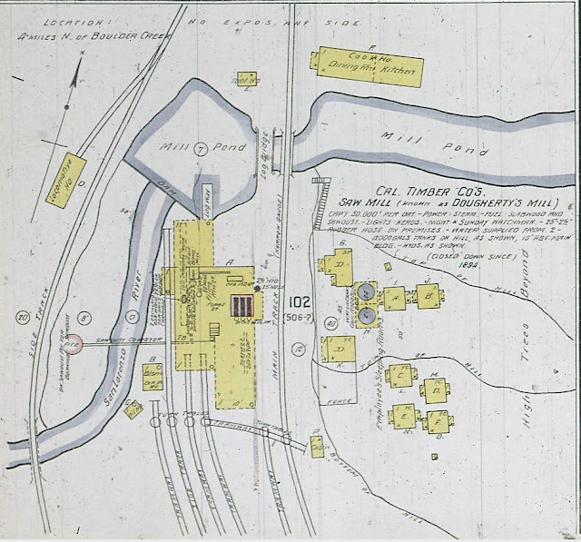
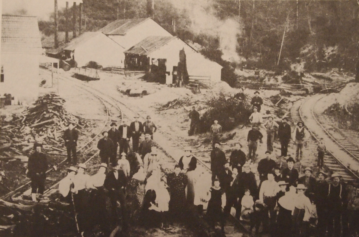
The shortest branch line in Santa Cruz County, the one-mile route to the California Timber Company mill on Newell Creek was installed by Southern Pacific in 1905. After the San Francisco Earthquake, the line to the mill was standard-gauged and the railroad upgraded its status to the Newell Creek Branch around October 1908. All of the trackage north of the mill continued to be narrow-gauge and was privately owned by the lumber company. The mill shut down in 1913 but the branch remained in station books until 1920, when it was formally abandoned.

Davenport Branch (1917 – 1985)
This line began life as the Coast Line Railroad, but as early as July 1907 local newspapers called it the Davenport Branch and on August 24, 1917, the name change became official when Southern Pacific absorbed its subsidiary. Regularly-scheduled passenger service along the line ended on July 21, 1932, although excursion trains continued through the 1950s. The line was annexed to the Santa Cruz Branch around 1985 after the Santa Cruz to Olympia trackage was sold to Roaring Camp Railroads. As a part of the Santa Cruz Branch, it was sold to the Santa Cruz County Regional Transportation Commission in 2012.

Los Gatos Branch (1940 – 1959)
The northern three miles of the former College Park & Santa Cruz Branch survived for nineteen years as the Los Gatos Branch until the people of Los Gatos requested that Southern Pacific abandon its route through downtown. On June 16, 1958, the petition was filed with the Interstate Commerce Commission and abandonment was approved on December 30. Formal service ended on January 23, 1959 and the final run happened on January 25, which concluded with a spike-pulling ceremony overseen by Coast Division superintendent R. A. Miller. The right-of-way was quickly converted into parking lots by the town of Los Gatos.

Vasona Branch (1959 – 1964)
When the mountain route was officially abandoned in November 1940, the Los Altos Branch was renamed the Vasona Branch and the name Mayfield Cut-Off went into disuse since it no longer cut off the route between Santa Cruz and San Francisco. When the Los Gatos Branch was abandoned in 1959, the stop at Vasona Junction became the commuter terminal for Los Gatos area passengers. Low patronage at the station and plans to cut the Vasona Branch between Simla and Alta Mesa to make room for Foothill Expressway in 1962 led to a petition to abandon the station on March 21. But the Interstate Commerce Commission provided a brief reprieve on October 25, 1963 when it disallowed Southern Pacific from ending service between the points, in effect also delaying construction of the expressway. After another petition to the ICC, abandonment was approved and the last run along the branch occurred on January 27, 1964. The portion of the track south of Foothill Expressway continues to exist today as a freight line ending at the Lehigh Permanente quarry to the west of Cupertino. Discussions to rehabilitate this line and even extend it to the outskirts of Los Gatos have been discussed for over two decades but no progress has been made.

Salinas Subdivision (c. 1936 – 1985)
At some point in the mid-1930s, the San Francisco Subdivision was divided and the Monterey Branch became a part of the new Salinas Subdivision. This route included all the trackage from Watsonville Junction up the Salinas Valley to San Luis Obispo, at which point the Guadalupe Subdivision continued to Santa Barbara. In 1964, the subdivision was extended north to San Jose and both the Santa Cruz and Davenport Branches became a part of it. In 1985, the Salinas Subdivision was dissolved and all Monterey Bay branches once more became a part of the San Francisco Subdivision.

Gilroy Subdivision (c. 1946 – 1964)
In 1942, a new Gilroy Subdivision appeared to handle traffic between San Jose and Watsonville Junction and it included the Santa Cruz and Davenport Branches. The subdivision was dissolved in 1964 and both branches were annexed to the Salinas Subdivision.

Later Divisions (1964 – 1996)
In its later years, Southern Pacific shifted their focus along the Central Coast to freight, which led to smaller timetables and fewer passenger schedules. In 1964, the Coast Division became the Western Division and annexed several neighboring divisions in the process. In 1985, the division system was abandoned and Santa Cruz County fell into the Northern Region and, in 1987, the Western Region. It remained within that region until Union Pacific took over in 1996. Within the Western Region, local trackage fell under the authority of the Coast District, a spiritual successor to the Coast Division.

A page from the first Western Division employee timetable, April 26, 1964.
Citations & Credits:

Maps: Ben Lomond to Boulder Creek

$
0
0
The gentle curves and relatively unimpeded journey between Felton and Ben Lomond ended just north of the latter town. As the Felton & Pescadero Railroad carved its grade north to Boulder Creek, the route proved much more perilous and required several crossings. But there were several stops and stations, almost all registered on Southern Pacific Railroad timetables and station books, and it was also quite possibly the most scenic sections of track in Santa Cruz County.

The first bridge over the San Lorenzo River north of Ben Lomond, c. 1910. [George Pepper]
Leaving Ben Lomond, the right-of-way curved behind the current Tyrolean Inn to cross the San Lorenzo River on a mixed trestle-truss bridge. From there, it passed through a large open meadow that would host a number of campgrounds over the years, most notably Camp Thunder, before it was converted into a housing subdivision. Riverside Drive north of Ben Lomond marks the right-of-way in this section and can be easily visited today, although no railroad relics remain beside the road.

Railroad route between Ben Lomond and Boulder Creek, 1885-1934. Structures and spur lengths not to scale.
[Derek R. Whaley]
View from the top of a railroad bridge showing the swimming hole north of Siesta, c. 1915. [Derek R. Whaley]
From this meadow, the railroad tracks crossed the San Lorenzo River over one of the most spectacular bridges in the county, after which it ran along the southern side of River Road in a steep cut between the road and the river. Here, the railroad passed its first stop along this stretch: Phillipshurst, established to cater to Dr. Phillips who lived just across the river. Phillips's estate would later become the Blake-Hammond Manor and can still be sighted, with some difficulty, from State Route 9. Unfortunately, the right-of-way in this section is accessible only via River Road, which is privately-owned and maintained so trespassing is not advised. Just before crossing the San Lorenzo River an open deck bridge, the railroad passed the summer cottage of Fred Swanton, who convinced Southern Pacific to set up a stop named Siesta. This stop is also on private land near the southern end of Redwood Street off Riverside Road in Brookdale.

The Fish Hatchery at Brookdale, c. 1920. [Craig Polson]
On the other side of the river, after crossing Larkspur Street, the right-of-way passed the Brookdale Fish Hatchery, established by Judge John H. Logan and run by the California Department of Fish & Game. Either because of freight needs or due to its popularity as a tourist destination, the railroad established a stop here named Fish Hatchery, probably along Old River Lane. The tracks continued to hug the west bank of the San Lorenzo River as it rounded to the west toward Clear Creek, which a short open deck bridge crossed just before reaching Brookdale. None of the right-of-way in this area is really accessible and all of it sits on private property.

Brookdale Station with a train approaching, c. 1920. [Craig Polson]
Brookdale is the first station site along this stretch that can still be viewed, although it still sits on private property. The station was located at the bottom of Pacific Street just before the road crosses over to Huckleberry Island. The old post office on the west side of the street still sits as a private residence, but the station itself has been demolished. The large property situated here provided space for the spur and, later, siding that catered to the station, and also allowed room for the fill that preceded the bridge over the river to the west. The railroad tracks once crossed the San Lorenzo River here, and sawed-off pilings of it can still be seen on either side of the river. The tracks then passed through a shallow cut at the back of Huckleberry Island before crossing the river a second time on the other side. While the bridge to the south of the island was composed entirely of wood, the bridge to the north included concrete piers, which are still present today, although it is impossible to see them since the adjacent properties block line-of-sight. Huckleberry Island may well have served as the railroad's only unofficial picnic stop along the Boulder Creek Branch, but evidence is scarce.

Passenger train in the Boulder Creek yard, c. 1890s. [Margaret Koch]
From Irwin Way, the railroad crossed the river a sixth time and the concrete piers for this can be seen just to the north from the vehicular bridge over the river. The right-of-way then turned sharply to the west to parallel the river for a short distance, eventually passing into a shallow cut on its way to the Boulder Mill. In later years, the Boulder Mill was renamed Harris, although this stop catered to Camp Joy. All of the right-of-way in this section is on private property and a gate blocks access after a short distance down Irwin Way, although the gated road once served as the railroad right-of-way. Just past Harris, the tracks crossed the river for a seventh and final time, also crossing Malosky Creek in the process. The right-of-way then straightened out on its approach to Filbert, near the end of Grove Street. Little evidence remains of the railroad in this section except the single concrete pier and some overgrown sawed-off pilings beside the river. However, Redwood Resort lingers on as the successor to the Redwood Rest Resort, which probably was the chief patron of Filbert station in later years since the stop was directly behind the resort.

Central Avenue in Boulder Creek, 1900. [Kilroy Was Here]
Creeping through the back yards of Boulder Creek homes and businesses on a narrow shelf just above the west bank of the river, the Boulder Creek Branch finally broke out into its large freight yard at the place where East Lomond Street turns to the north. From here, tracks split apart in several different directions, with some staying close to the river and others running just behind the businesses on Central Avenue. One track even wrapped up Lorenzo Street to access the Southern Lumber Company yard that was once located where the post office and Liberty Bank is today. The station itself was located just behind the Boulder Creek Fire Department, roughly where the Boulder Creek Recreation building sits at the corner of Middleton Avenue and Railroad Avenue. Except for names—Railroad Avenue, Junction Avenue, Junction Park, Middleton Avenue—nothing from the railroading days survives in the massive open meadow that once was home to the freight yard. But the train did continue on to the north, following Junction Avenue across Boulder Creek, the San Lorenzo River, and then Bear Creek—but that's a story for a different time.

Citations & Credits: 

Freight Stops: Alameda Lumber Mill

$
0
0
North of the town of Boulder Creek, there are several tributaries of the San Lorenzo River that meander up either side of the valley's walls. Bear Creek, the second such stream, hosted several lumber mills along its length over the years, but the mill operated by the Alameda Lumber Company, owned by Austin S. and Oscar R. Harmon, was the longest-lived and most well known. The brothers were natives of Maine but moved to the San Lorenzo Valley in 1867 to work at Joseph W. Peery's mill on Two Bar Creek. After that mill closed, they tried some other professions before returning to the lumber industry.

In 1873, the brothers founded the Bear Creek Toll Road Company and spent two years creating a road between the small town of Lorenzo and Lexington south of Los Gatos. The goal of the project was to make it easier for lumber and split stuff to be hauled out of the upper San Lorenzo Valley to the Santa Clara Valley. Unfortunately for the Harmons, though, soon after the road was built, the San Lorenzo Valley Flume was completed, creating a more efficient and easier way to ship out lumber. Santa Cruz County eventually purchased the failed toll road in 1890 and it became Bear Creek Road.

Excerpt of the Official Map of Santa Cruz County, 1889, showing the location of the Harmon Brothers' timber tract along Harmon Gulch (top right) in relation to Boulder Creek (bottom left). [Library of Congress]
Once the flume was built and the unprofitability of the toll road proven, the Harmons decided to return to the lumber business. In 1876, the brothers incorporated the Alameda Lumber Company and began purchasing timberland north of Boulder Creek. They purchased several tracks on either side of the San Lorenzo River about a quarter mile north of town, but their main tract was up a seasonal tributary of Bear Creek now called Harmon Gulch. Like many other lumber firms in the area, the Harmons harvested lumber on their own lands as well as on adjacent lands through lease agreements.

For its first few years, the Harmon Gulch mill was a relatively small-scale affair that focused primarily on cutting railroad crossties. All of the cut timber was hauled to the small mill via oxen teams that dragged the cut logs down skid roads to the mill near the gulch's base. From there, they likely shipped the ties over their toll road to Lexington and beyond. In 1880, the brothers gave up completely on their road and began sawing lumber to send downstream along the flume at the bottom of Bear Creek.

The arrival of the Dougherty Extension Railroad in August 1887 replaced the increasing problems with the flume and provided the Harmons with a truly profitable way to ship their lumber. While no railroad tracks ever came near the mill, a spur at the bottom of Bear Creek was probably installed for the mill's use. By 1889, the mill had a daily capacity of 10,000 board feet of lumber and employed 45 men.

A series of tragedies led to an eventual end to the Harmon Brothers' venture up Harmon Gulch. In 1887, Austin Harmon died from a head wound received in the field. Three years later, the mill burned down, although Oscar Harmon rebuilt. At the end of the 1898 cutting season, Oscar retired and sold the land to J. H. Olsen, who sold the property to the Santa Clara Valley Mill & Lumber Company two years later. Oscar, meanwhile, died in 1899. The remaining timber was harvested throughout 1901 and then the mill was sold to the Enterprise Lumber & Development Company, which ended up abandoning the structures and machinery the next year.

Geo-Coordinates & Access Rights:
Approximately 37.1437N, 122.0897W

The site of the mill still hosted machinery into the 1920s, at which time it disappeared and was developed into a private residence. Its location was probably in the vicinity of Fernwood Drive across from Harmon Gulch Road approximately 2.5 miles up Bear Creek Road.

Citations & Credits:

    Freight Stops: Morrell Mill on Two Bar Creek

    $
    0
    0
    Just over a mile north of Boulder Creek, an oddly-named tributary of the San Lorenzo River meanders through a wooded gulch down the western side of Mount Bielawski. The so-called Two Bar Creek has never been the most prominent or important stream in the area but it did host a single mill with a succession of owners.

    Ephraim Bradbury Morrell—or just Brad—a native of Maine, began his career in Santa Cruz County not on Two Bar Creek but in Cleveland Gulch near the Glenwood-Laurel Tunnel in 1881. In May of that year, Morrell erected a sawmill with a capacity of 25,000 board feet of lumber per day. For three years, he shipped out lumber cut at this mill via the railroad station at Highland (later Laurel) via a hauling road that is now Morrell Mill Road.


    Official Map of Santa Cruz County by W. S. Rodgers, 1889, showing the tracts harvested by Morrell and the McAbees.
    [Library of Congress]
    In April 1884, with little left to harvest along the headwaters of Soquel Creek, Morrell packed up his equipment and shipped it to Two Bar Creek to the property of E. P. Reed, who owned a 450-acre parcel through which the San Lorenzo Valley flume passed. Reed acted as site superintendent, as well. Morrell probably used Bear Creek Road to get his machinery to the site, since transporting it up the future State Route 9 would have been difficult and more roundabout. The new mill opened in May and likely harvested the timber on William Maitland's extensive property further up the creek, since Maitland worked at the mill in 1885. By 1886, the mill had a daily capacity of 12,000 board feet of lumber and employed twenty men. During this time, Morrell was under contract with the San Jose Mill & Lumber Company to deliver 3,000,000 feet of lumber annually, all of which was shipped by ox team over Bear Creek Road rather than flume, but a dispute arose over payment, ending the arrangement.

    With the arrival of the Dougherty Extension Railroad in 1888, Morrell's mill switched to using the railroad to ship its goods. Indeed, around February, it became one of the first freight stops along the new line and a spur was soon installed to the mill. For several years, little is known about the mill, but the economic recession of the mid-1890s impacted operations there. In August 1896, the mill shut down. It would not reopen under Morrell's management. For the following two summers, it remained closed. Around 1899, the firm of Hubbard & Carmichael, which had harvested previously in the Ben Lomond area, was brought on to cut the remaining timber on Morrell's lands. They finished operations there in September 1900 and relocated to Oil Creek near the headwaters of Pescadero Creek. Morrell himself lived in Boulder Creek until his death at 68 on July 5, 1903.


    The Morrell Mill on Two Bar Creek with railroad tracks in the foreground, c. 1904.
    [UC Santa Cruz Special Collections]
    In late 1900 or early 1901, either Morrell or Hubbard & Carmichael sold the former Reed property to two brothers, Orrin L. and Williard O. McAbee. The Sentinel reports in April 1901 that they struck a vein of coal on Twobar Creek, although this ultimately proved an unprofitable venture. The brothers were better associated with the area to the north of Big Basin, where they owned a large timber property above Pescadero Creek harvested by Homer M. Rider, a well-known Corralitos mill owner. Rider and the McAbee brothers went into partnership as McAbee Bros & Rider Company in May 1904 and purchased the old Morrell mill as well as the timber rights of William F. Horstman, who owned the last significant tract of old growth redwood along Two Bar Creek. Orrin was designated superintendent of this operation and, despite plans to relocate it further up the creek, the old mill remained at its former site beside the railroad tracks at the bottom of Two Bar Creek. For two years, the Horstman tract was cut and the felled timber hauled to the bottom of the gulch, where it was cut at the mill and then loaded onto railcars for shipment to Boulder Creek.

    As the senior partners, the McAbee Brothers renamed their corporation McAbee Bros Timber Company in June 1904 and purchased timber rights to 320 acres of G. H. and Kate Harrington's land on the western side of Big Basin near China Grade. They also began plans to establish a subdivision named Sequoia upon the property. Early on, disaster struck and a fire in September burned much of their land and their sawmill. Meanwhile, operations continued on the Horstman lands along Two Bar Creek.

    In November 1905, Rider sold his interest in the McAbee Bros Timber Company to the Henry Cowell Lime & Cement Company, which owned several tracts of timberland north of Boulder Creek. Preparations began immediately to remove the former Morrell mill from its location at the bottom of Two Bar Creek to a site at the headwaters of Boulder Creek to the west. This location was originally two properties: a homestead owned by J. W. Sylvester who sold it to Davis & Cowell; and a 160 acre tract originally owned by Samuel Grosh and purchased by Davis & Cowell around 1881. Together, they comprised around 800 acres of timberland. The mill was moved early in 1906, but additional parts needed to complete the complex were delayed due to the San Francisco Earthquake, which struck in April. Once operations finally began, the partners reincorporated as the Southern Lumber Company and purchased the Chase Lumber Company yard at the Santa Cruz Union Depot and a smaller yard alongside Boulder Creek in the town of Boulder Creek. In 1909, they further increased their local production capabilities by buying L. F. Pitt's shingle mill and box factory situated in the Boulder Creek freight yard. The improved mill, meanwhile, relocated to a location deeper within the timber tracts in April 1910. This marked the height of Southern Lumber operations in Santa Cruz County.

    On February 2, 1918, the shingle mill and box factory burned down, and this likely marks the end of any significant presence in Boulder Creek or the San Lorenzo Valley. Southern Lumber had spread its wings throughout the 1910s and established a distribution yard in San José and other mills throughout the Central Coast. The McAbees themselves remained in town, however. Orrin died suddenly in 1925 from a drowning incident, while is brother passed away nine years later. They had relinquished control over their company in the years prior and moved on to other ventures. In April 1936, the company was taken over by Ed Pohle whose family has controlled the firm ever since.

    Geo-Coordinates & Access Rights:
    Approx. 37.1435N, 122.1323W

    The location of the Morrell mill was probably at or near the current location of Lee & Associates Rescue Equipment at the end of Two Bar Road, between State Route 9 and the San Lorenzo River. The Dougherty Extension Railroad passed directly through this property, as did the flume before it. It is currently a private residence and trespassing is not encouraged.

    Citations & Credits:

    Freight Stops: Cunningham Mill

    $
    0
    0
    At its junction with Kings Creek. the San Lorenzo River makes an unusual set of turns around a small square outcropping of rock, forming in the process a near-complete square. It is in the center of this square that the San Lorenzo Valley Flume & Lumber Company erected its primary mill in 1875. From this point, prefabricated pieces of v-flume were sent down the completed portion of the flume, at which end workers appended the new section. This continued throughout much of 1875 until the flume reached Felton over eight miles to the south. After this point, the mill became just one of several that shipped lumber down the flume during the twelve years of the flume's existence. Little about the mill is known from this time and only one deteriorated photograph of the mill survives.

    With the arrival of the Felton & Pescadero Railroad to Boulder Creek in 1885, operations at the flume mill slowed and other nearby lumber ventures were incorporated or began increasing their output. James F. Cunningham was one such entrepreneur. Cunningham had made a name for himself in the San Lorenzo Valley as a businessman and financier, and he had his hands in many different cookie jars. In Felton, he began in 1871 as part owner of the town's general store before opening up his own rival store in 1873. At this time, he was also an investor and secretary of the San Lorenzo Valley Railroad Company, which collapsed in 1874. Once the flume opened in late 1875, Cunningham's store became as much a hardware and lumber shop as a general store and the mercantile venture made Cunningham a successful local magnate. He became a county supervisor in 1878, became Felton's postmaster, and took over management of the Big Tree House. In 1880, he became a state assemblyperson.

    Cunningham's interest in the lumber industry began around 1882, when he opened a shingle mill in Felton. By 1884, he was shipping ten flatcars of shingles per day from the mill and had become the second largest producer of timber in the San Lorenzo Valley. It was for this reason that the South Pacific Coast Railroad hired his firm to harvest the timber near the Turkey Foot (Boulder Creek) in preparation for the new freight yard the company intended to build there. Cunningham relocated his mill to the floodplain and was granted land along the main road, upon which he built a general store and private home. Cunningham quickly joined forces with James Dougherty and Henry L. Middleton, owners of the Santa Clara Valley Mill & Lumber Company, and together they began to make plans for harvesting the lumber north of Boulder Creek.

    Cunningham & Company crews with family members posing in front of the mill, c. 1890. James Cunningham with large white hat at right. [San Lorenzo Valley Museum]
    As early as 1886, Cunningham took over operation of the flume mill and possibly the flume itself, which now terminated in the freight yard that was partially owned by Cunningham. In May 1888, the old mill was either replaced or heavily upgraded to produce 60,000 board feet of lumber per day. To support the mill, the river was dammed, thereby creating a mill pond. Forty people were employed at the mill during the summer months and for the first year of operation, crews worked around the clock to fulfil a contract for the Santa Clara Valley Mill & Lumber Company, which was recovering from a fire at its Zayante mill and delayed in relocating operations to a new site north of Cunningham's mill.

    The Dougherty Extension Railroad was ostensibly built to support the Santa Clara Valley Mill & Lumber Company's mill, but delays meant that it was Cunningham that primarily benefited from it during its first year of operation. Spurs and sidings were installed within the mill property, while a small truss bridge over the millpond was located just to the north. Unfortunately for Cunningham, his location was not sustainable in the long term since the area had already been harvested heavily for a decade.

    In 1889, Cunningham attempted to break into the Santa Cruz market, directly challenging the status quo maintained by the Loma Prieta Lumber Company and Grover & Company. As production at his mill declined and the rivalry downtown intensified, Cunningham found himself with few friends. Dougherty and Middleton deprived him of his Boulder Creek general store in 1891 and Cunningham took it as a sign and moved to San José. He sold his mill to the Santa Clara Valley Mill & Lumber Company late that year and the machinery was eventually moved up to Deer Creek, where a new mill was established in 1902. The mill pond was destroyed in 1904 to allow fish to properly migrate upstream. In 1894, Cunningham merged his company with Grover & Company, but mounting debts led him to sell the company to Grover outright in 1897. He left the area permanently afterwards and died in San José in 1907. Second-growth redwood trees quickly overtook the former mill site north of Boulder Creek and it remains a heavily-wooded area today.

    Citations & Credits:
    37.1519N, 122.1368W

    The site of the Cunningham Mill is accessible from State Route 9 along Riverside Drive just south of Garrahan Park. The area is now a small housing subdivision and no remnants of the original railroad right-of-way or the former mill survive in this area, although reminders of it still appear on property surveys. Trespassing on the properties of local residents is not encouraged.

    Citations & Credits:

    Picnic Stops: Wildwood

    $
    0
    0
    The lumber industry in the San Lorenzo Valley was on a sharp decline at the beginning of the 1910s, but local entrepreneurs and real estate investors saw potential in the vast tracts of second-growth redwood forest that was left behind. Property developers from all over the nation were drawn to the untapped acreage north of Boulder Creek in the hope that they would establish the valley's next large settlement or create a destination resort. This was certainly the case for the large clearing just north of the site of the old Cunningham & Company mill, which was dismantled in 1902.

    Marketing postcard of Wildwood showing a group picnic, 1915. [Derek R. Whaley]
    In 1909, the American Real Estate Company purchased the land from W. H. Booth with the aspirational intention of subdividing the 320 acres of land situated on the west bank of the San Lorenzo River into scores of small parcels upon which investors could build small vacation cottages. George H. Wiley was brought in to oversee property sales and immediately christened the subdivision Wildwood, establishing a camping area there to provide further encouragement to investors. Maps even today show the optimistic grid pattern planned for the area, with several roads mapped out between tiny lots that quickly climbed the hillside behind the Wildwood camp ground. By 1910, approximately fifty families had purchased property.

    Wildwood Camp showing the boarding house at left, with camping tents, c. 1914. [Derek R. Whaley]
    For the next four years, Wiley worked out an arrangement with the California Timber Company to use the Dougherty Extension Railroad to shuttle potential investors up to Wildwood from Boulder Creek. During these years, the former Santa Cruz & Felton Railroad locomotive known as the Dinky (originally the Felton) ran the excursion runs when they were requested. The California Timber Company continued to maintain the right-of-way, since they were still using it periodically, while the real estate firm was responsible for maintaining the rolling stock.

    The Dinky making a promotional run along the Dougherty Extension Railroad, c. 1912.
    [San Lorenzo Valley Museum]
    Demand for property and, specifically, development of the area increased significantly in mid-1910 prompting the real estate firm to purchase additional property across the river, which they labelled Wildwood No. 2. Within the original site, a boarding house was erected which also acted as a small general store and real estate office. As many as six-car trains delivered potential residents to Wildwood on busy weekends days, with many visitors coming just for the scenery. Lots sold for around $125, while prebuilt homes ranged from $250-$600.

    The promotional autobus on the Dougherty Extension Railroad at Wildwood, c. 1914. [Derek R. Whaley]
    The autobus cruising along the Dougherty
    Extension Railroad toward Wildwood,
    c. 1913. [Rick Hamman]
    By 1913, sales had stagnated and the firm rebranded itself as the Wildwood Development Company. At the same time, they redirected their marketing to wealthy Oakland residents, many of whom enjoyed vacationing in Santa Cruz County during the summer months. The aging Dinky was replaced at this time with a new electric autobus that ran along the rails. As a part of this conversion, and due to the fact that the California Timber Company had stopped using the tracks, the rail line was renamed the Wildwood, Boulder Creek & Northern Railroad.

    From 1913-1915, potential customers, seasonal vacationers, and permanent residents rode up from Boulder Creek on the autobus but sales continued to stagnate. Promises to install an artificial lake in the river and other promises did not come to fruition. The remoteness of the location and the rapidly increasing use of the automobile, especially by the wealthier population, led to fewer people purchasing remote cottages in the forest. The railroad ceased to convey passengers in June 1915, after which potential customers were transported from Boulder Creek via wagons or buses.

    Geo-Coordinates & Access Rights:
    37.1523N, 122.1365W

    Today, Wildwood remains a relatively small community located mostly off Pleasant Way. The small Wildwood No. 2 area is just across the river behind Garrahan Park, accessible via Sequoia Road. Garrahan Park itself, as well as the surrounding neighborhoods, are part of the separate Rices Junction subdivision. Although the area remains heavily parcelled on official maps, few homes actually occupy most of the lots and most of the roads were never built. Only the area beside the river was actually developed to any significant extent.

    Citations & Credits:

    Freight Stops: Hihn Mill on Kings Creek

    $
    0
    0
    James King is not a person that comes up much when discussing Santa Cruz County history. Born in Missouri, King later established a small cattle ranch and homestead in a clearing two miles north of Boulder Creek at the confluence of a small meandering creek and the San Lorenzo River. King disappears from history soon after this, but he lives on through the creek named after him. By the mid-1880s, the area of Kings Creek was teeming with activity. Near the bottom of the creek, the flume had its primarily mill, which in later years became home to Cunningham & Company. Further up the creek, homesteads arose and various lumber firms cut timber well into the 1900s. But enough virgin redwood survived for the F. A. Hihn Company to make a profit.

    F. A. Hihn Company crews posing for a photograph at the Kings Creek mill, 1908.
    [Santa Cruz Museum of Art & History]
    On April 18, 1906, the earth shook and operations at Hihn's mill at Laurel ground to a halt. Although the mill returned to operations shortly afterwards, damage to the railroad line ensured that only small amounts of lumber could be hauled out of the isolated valley at the top of Soquel Creek. Fortunately for the lumber industry, demand was now at a peak with half of San Francisco burned to the ground and thousands of buildings across the Bay Area in need of repair or rebuilding. Hihn began searching across Santa Cruz County for other available timber tracts to harvest and his eyes fell upon Kings Creek, where a settler named Newman owned a large unharvested parcel.

    Primary Hihn mill on Kings Creek, 1908. [Santa Cruz Museum of Art & History]
    In early 1907, F. A. Hihn Company crews began hauling equipment up to the junction of Kings Creek and Logan Creek, a small seasonal tributary. There crews erected a small 30,000 board feet capacity mill that utilized steam-powered saws, probably brought over from Laurel. Although most of the mill was constructed by March, poor weather and a recession delayed opening of the mill until September. There was also talk at this time of extending the Dougherty Extension Railroad up Kings Creek from the bottom of the valley, with plans to even extend the line to Los Gatos. These plans fell apart, though, and only a short spur at the bottom of Kings Creek, splitting off from the main track near the old Cunningham mill site, was ever installed to cater to the mill.

    The tramways to the lumber stacks at the Kings Creek mill, 1908. [Santa Cruz Museum of Art & History]
    In April 1908, full operations at the mill finally began with a crew of 45 men cutting trees and timber. Good financial and weather conditions allowed operations to continue until November of that year, with a total yield of three million board feet produced in just the first full year of operation. For the next two years, the mill continued to cut at capacity with all of the lumber shipped to the Santa Cruz Lumber Company yard at the Santa Cruz Union Depot. A corporate takeover in 1909 meant that the lumber, once cut, became the property of the Hihn-Hammond Company, but that barely impacted daily operations.

    Two horse teams idling in the lumber yard at the Kings Creek mill, 1908. [Santa Cruz Museum of Art & History]
    In November 1910, crews determined that there was insufficient timber for another season and the mill closed. The equipment was removed and returned to Laurel, which resumed its former status as the primary Hihn mill in the county for several more years. Southern Pacific once again returned to the idea of building a branch line between Boulder Creek and Los Gatos in 1912, but the idea never materialized. The spur track was probably removed soon afterwards. The area around the spur was developed into Wildwood No. 2 and Rices Junction, while the mill property itself returned to a state of nature.

    Geo-Coordinates & Access Rights:
    Approx. 37.1850N, 122.1228W

    The site of the mill is now a private property located 2.5 miles up Kings Creek. Nothing visible remains of the mill, although ironically, a more modern railroad flatcar functions as a bridge over the creek today. Trespassing on the property is not advised.

    Citations & Credits:

    Freight Stops: Santa Clara Valley Mill & Lumber Company Mill

    $
    0
    0
    The Santa Clara Valley Mill & Lumber Company was no rookie on the field in the spring of 1888. Founded in 1873 by William Patrick Dougherty with the support of his younger brother, James, the company had systematically harvested almost all of the saleable timber along the western side of Los Gatos Creek in the 1870s, after which it did the same along the upper half of Zayante Creek. But a massive fire in August 1886 destroyed the lumber mill at Zayante and forced most of the residents of the mill town to flee to other areas in the San Lorenzo Valley. The Dougherty brothers replaced the burned husk with a large shingle mill later that year, but the remaining timber was insufficient to justify a resurrection of the once-impressive lumber mill.

    In the several years prior to the fire, the company had begun buying tracts of timber along the San Lorenzo River north of the flume mill (later Cunningham Mill) in areas that the San Lorenzo Valley lumber flume did not or could not reach. With sufficient lumber providers located further south along the flume, there was no reason to harvest timber north of the flume mill, so thousands of old growth redwood forest sat idle, awaiting a change in the market. The disaster at the Zayante mill finally convinced the Doughertys to relocate to this untapped area.

    Santa Clara Valley Mill & Lumber Company mill north of Boulder Creek, 1895. [San Lorenzo Valley Museum]
    As December 1887 approached, company workers began grading a railroad bed between the the Felton & Pescadero Railroad yard at Boulder Creek and the proposed Santa Clara Valley Mill & Lumber Company mill site four miles to the north, just below a convenient bend in the river where a dam could easily and relatively naturally be installed to create a mill pond. Most of the initial machinery for the mill was composed of surviving parts of the Zayante mill, supplemented with the newer machinery bought in late 1886 to replaced the destroyed components. These parts arrived at the new mill in May 1888, after the railroad tracks to the site were completed. Cunningham & Company, which was a sometimes partner and other times rival of the Doughertys, provided the lumber used in erecting the mill. When the mill opened on June 1, 1888, it was capable of producing up to 60,000 board feet of lumber per day. Over 100 workers, mostly foreigners, lived and worked at the mill prompting the creation of the Dougherty School in 1889. But as so often happens with sawmills in the Santa Cruz Mountains, the Dougherty brothers' first mill north of Boulder Creak met a fiery end in September 1888, less than four months after opening.

    1892 Sanborn Map of the Santa Clara Valley Mill & Lumber Company facilities north of Boulder Creek.
    [UC Santa Cruz Digital Collections]
    The brothers subcontracted their orders to Cunningham & Company, which reaped great profits during the following year, although this unexpected influx of money led to the company's overextension and collapse during the recession of the 1890s. Meanwhile, the Doughertys rebuilt. A new mill was operating by November but the mill did not return to full operation until the following spring. From 1889 to 1891—three seasons—the mill fulfilled its contracts and ran at capacity. And then, in October 1891, the mill burned down for a second time. By this point, Cunningham & Company had moved its operations to Santa Cruz so the Santa Clara Mill & Lumber Company simply purchased the recently-vacated mill of its rival and relocated it to the north. As the 1890s recession receded in the mid-1890s, the Doughertys began increasing productions and improving facilities, reaching a daily capacity of 50,000 board feet.

    This third and final mill is well documented by two Sanborn Fire Insurance Maps. The main track of the Dougherty Extension Railroad, which originally terminated at the mill, eventually continued north on the east side of the main mill. Two spurs, however, broke off to terminate in front of the mill, while four tramways also ran from the mill in order to shuttle lumber onto stacks. A third spur crossed the San Lorenzo River to the west of the mill and wrapped around the entire facility, reuniting with the main track north of the mill. It was along a short branch of this spur that the Doughertys installed an engine house for their single locomotive, the former Santa Cruz & Felton locomotive popularly nicknamed the Dinky (originally the Felton). Photograph evidence also confirms that another spur broke off from the mainline north of the mill at terminated a short distance to the east behind the employee cook house. This may have been where the locomotive's water tower was installed.

    1908 Sanborn Map showing the California Timber Company facilities north of Boulder Creek in their final years.
    [UC Santa Cruz Digital Collections]
    Doughertys, as the mill and surrounding settlement became known, reached its peak in the late 1890s, although William Dougherty never lived to see this having died in 1894. His brother, James, and Henry L. Middleton, a prominent lumber investor and Boulder Creek's de facto mayor, continued to direct the company in its final years. During this time, Doughertys became a popular tourist location, with picnickers visiting on weekends and camping in unharvested redwood groves or areas that were already in the process of recovery further to the south. As must inevitably happen, though, the timber tracts in the San Lorenzo Valley were nearly all harvested by the end of the century. In 1900, the Dougherty Extension Railroad was extended to its maximum length after which time operations shifted to harvesting a tract of timber near Waterman Gap. In 1902, company's final property along Bear Creek was cut, although it is unclear if the timber from this location was processed at Doughertys or in Boulder Creek. James Dougherty's death in July 1900 signalled the spiritual end of operations, even if they limped along for two more seasons.

    In 1903, the Dougherty widows, Middleton, and Loma Prieta Lumber Company chief investor Timothy Hopkins consolidated most of the remaining lumber operations north of Boulder Creek into a new firm titled the California Timber Company. The company quickly packaged up most of the mill's machinery and hauled it far up Bear Creek to a tributary called Deer Creek, which they harvested for several more years. Meanwhile, the remains of Doughertys sat mostly vacant. Some former employees continued to live in their cottages while just to the north, plans were put in place to found a new subdivision named Driftwood, centered around James Dougherty's former home of the same name. The venture proved fleeting, though, and the most of the remaining residents moved elsewhere. The railroad tracks through the site continued to be used by workers at the Pescadero mill until the end of 1913, after which the school shut down and the track was pulled for scrap. Despite several attempts to start a subdivision there, none succeeded for over two decades.

    Geo-Coordinates & Access Rights:
    37.1714N, 122.1397W

    The area of Doughertys eventually became the subdivision known as Riverside Grove, established in May 1935. It is accessible off of State Route 9 from Teilh Drive. The mill site itself is south of Riverside Grove, located at the end of Either Way off of Teilh. No signs of the mill or railroad track remains in the immediate vicinity due to subsequent residential developments. A reminder of logging days remains with "Lake Street" sitting along the former site of the log pond. Some property lines also still hint at the railroad's right-of-way, although the right-of-way is otherwise difficult to discern in this area.

    Citations & Credits:
    • Hamman, Rick. California's Central Coast Railways. Second edition. Santa Cruz, CA: Otter B Books, 2002.
    • Robinson, Lisa A. Images of America: The San Lorenzo Valley. Charleston, SC: Arcadia Press, 2012.
    • Whaley, Derek R. Santa Cruz Trains: Railroads of the Santa Cruz Mountains. Santa Cruz, CA, 2015.

    Freight Stops: Chase Lumber Company Mill on Feeder Creek

    $
    0
    0
    A mile beyond the Santa Clara Valley Mill & Lumber Company mill on the San Lorenzo River and five miles north of Boulder Creek, James B. Sinnott owned a homestead. When he first moved there in the mid-1880s, he probably cut down the redwood groves and sent them downriver either on the flume or on skid roads to Boulder Creek for processing into lumber. Afterwards, he established "Sky Ranch," upon which he likely raised some cattle and horses. Very little is known of the Sinnott family of Sky Ranch, but members of it remained there into the 1920s. The property itself was leased in the late 1880s to the business partners Peery & Steen to harvest lumber.

    In 1889, when the Dougherty Extension Railroad was lengthened for the first time beyond Doughertys, the route encountered Sinnott's ranch. An agreement between the lumber company and Sinnott was struck allowing the railroad tracks to pass through a corner the property. The next year, the Chase Lumber Company purchased a tract of timber northwest of Sky Ranch and decided that the most feasible way to get the timber to market was to build a spur off the Dougherty Extension Railroad to the mill. The Sinnott family was once again asked to grant a right-of-way through their land and, once they allowed this, Sinnott Switch became an informal stop along the rail line marking where the Chase mill spur broke off from the main extension railroad line. There is no evidence that the Sinnotts ever used the railroad at their mill, but several members of the family were active in local lumber operations so it is possible that they used the track to get to Doughertys and Boulder Creek, possibly through an arrangement with the Santa Clara Valley Mill & Lumber Company.

    The Chase Mill on Feeder Creek around 1895, showing the main structure in the back, a tramway at right, and the spur tracks somewhat obscured at left with a lumber car parked in the background. [Santa Cruz Museum of Art & History]
    The Chase Lumber Company was a local firm run by Stephen H. Chase, who had been active in the area for longer than the Dougherty brothers. He began with a small lumber mill near the Summit in 1863, the first operation in the Santa Cruz Mountains to haul its lumber to San José. The success of the venture prompted Chase to expand operations and build a planing mill in San José. One of his new mills was erected on Boulder Creek in 1884, which gave him a better idea of the San Lorenzo Valley logging industry as a whole. He initially used Bear Creek Road to ship his lumber, but switched to using the Felton & Pescadero Railroad when it was completed in 1885. The next year, he founded S. H. Chase & Company and, in 1889, he bought space in Santa Cruz for a lumber yard, thereby entering the competitive Santa Cruz market against Frederick A. Hihn, the Grovers, the Loma Prieta Lumber Company, and Cunningham & Company. To support this increased business, Chase purchased from Cunningham & Company several parcels near the headwaters of Feeder Creek five miles north of Boulder Creek.

    Google Map showing the rough route of the Chase Mill Spur, with
    Sinnott's Switch at bottom and the Chase Mill at top. [Google Maps]
    In 1891, Chase reincorporated as the Chase Lumber Company and began construction of the mill alongside the installation of a one-mile-long spur along the south bank of Feeder Creek from Sinnott Switch. Like the line it connected to, the spur was narrow-gauge and crudely made, but it did require a bridge across the San Lorenzo River, which may have been an impressive structure since the river cuts a broad and deep gulch in this section. The mill opened at the beginning of the 1892 season but shut down shortly afterwards due to a poor economic climate. In late autumn of the same year, much of the railroad trackage was destroyed in a landslide, forcing Chase to invest more in a mill that had yet to turn a profit. He decided to close the mill on Boulder Creek and turn all of his focus on the Feeder Creek mill. But profits would never come.

    In 1893, a lumber racket emerged in the Bay Area which encouraged price fixing. Chase refused to join and the Southern Pacific Railroad, which was invested in the scheme, retaliated by increasing Chase's freight costs at Boulder Creek. Chase fought the racket and eventually settled out of court. In the meantime, his mill finally began to make money in the mid-1890s. At peak capacity, the mill processed 25,000 board feet of lumber per day, which amounted to five carloads. The company continued to operate along Feeder Creek until around 1899, eventually relocating its operations to a tract along Laguna Creek near Davenport, followed by a small tract along Smith Grade in Bonny Doon. In 1905, Chase sold his lumber yard in Santa Cruz to the California Timber Company and left the county permanently.

    Chase died in 1915 but his son, J. A. Chase, continued to run the corporation for several more decades, albeit with a shifted focus on Northern California. The firm probably shut down in the late 1950s. The former trackage to Feeder Creek was seriously considered by Southern Pacific as a viable route to the Pescadero Creek basin until the San Francisco Earthquake in 1906 forced it to abandon all plans for future expansion in Santa Cruz County and its environs. The tracks to the mill were probably pulled around 1900 but may have lingered along with the rest of the Dougherty Extension Railroad until 1917.

    Geo-Coordinates & Access Rights:
    37.1918N, 122.1525W

    Almost nothing of the Chase Company mill or the spur to get to the mill survives today. The area through which the spur passed has remained uninhabited, a forgotten path on the south bank of Feeder Creek just south of Fern Drive north of Boulder Creek. Only a few cross-ties remaining visible, with most either buried or rotted away. A single piece of track stuck in a tree near the bottom of the grade is the only strong evidence remaining of the spur. The mill property is still a large block of land spanning almost all of the Feeder Creek basin and is rated for industrial use, though it is not currently being utilized for such. The junction of Feeder Creek with a smaller creek marks the rough site of the mill and some abandoned timber used in the construction of the mill still sits in disorderly piles around the site. Curiously, Google Maps records the address of the mill as 480 Chase Mill Road, despite the fact that no such road actually appears on any map. Clearly the legacy of Chase mill lives on.

    Citations & Credits: 
    • Hamman, Rick. California Central Coast Railways. Second edition. Santa Cruz: Otter B Books, 2002.
    • "Nicholas Paul Sinnott", Monterey County: Biographies.
    • Payne, Stephen Michael. "Felling the Giants", Santa Cruz Public Libraries. (From Stephen Michael Payne, A Howling Wilderness: A History of the Summit Road Area of the Santa Cruz Mountains 1850-1906, Santa Cruz: Loma Prieta Publishing, 1978).
    • Whaley, Derek R.Santa Cruz Trains: Railroads of the Santa Cruz Mountains. Santa Cruz, CA, 2015.

    Freight Stops: McGaffigan Switch

    $
    0
    0
    The Santa Clara Valley Mill & Lumber Company would not have found the success it did without the careful supervision of Patrick J. McGaffigan, who served as superintendent the company's operations north of Boulder Creek for a decade. McGaffigan, in addition to his skills as a manager, also became a relative of the Dougherty family through his daughter, Angeline B. McGaffigan, who married William James Dougherty, Jr., in 1897. As superintendent, McGaffigan was constantly on the move with timber crews, overseeing the cutting of specific groves and the loading of timber onto rolling stock for transport for the mill. As the tracks wound up the San Lorenzo Valley past the mill beginning in 1890, McGaffigan found it inconvenient to live so far from the site of the logging activities.

    He settled on a site 1.5 miles to the north of the mill that sat on a small hill that overlooked the Dougherty Extension Railroad tracks. Due to the heavy logging in the area, McGaffigan's home could probably look all the way south to the mill and quite a distance to the north, allowing him a good view of the activities over which he superintended. Although there are no surviving photographs of his home, descriptions of it suggest an elaborate and expansive Victorian-style house easily visible to anybody in the area. The fame of the home as a waypoint along the railroad and the likely presence of a short spur below the home gave the location the name McGaffigan Switch.

    The site, though, probably served a dual purpose, at least initially. When the track was first extended in 1890, it may have terminated at or near the site of McGaffigan Switch and served as the Dougherty mill's first logging camp. There is certainly enough space for such a camp at the site, which today is a narrow meadow along the west bank of the San Lorenzo River. The next location that could have functioned as a logging camp is Waterman Switch, which was not established for several more years, giving further credence to the idea that a logging camp was here. As with many logging camps, especially along railroad lines, the camp probably hosted a small shingle mill to process timber that was either too small to cut into lumber or had broken during felling. This would provide an explanation for the current name of the road through the area: McGaffigan Mill Road.

    Direct logging operations at McGaffigan Switch were fairly short-lived. Logging crews relocated their primary logging camp to Waterman Switch around 1897 and probably moved the shingle mill to the new camp at this time. While it is unclear whether McGaffigan continued as superintendent after 1897, both he and his son, James, remained at the home for several more years.  The fate of the property after they left is unclear, but it seems to have been demolished by the time the San Lorenzo Park subdivision was established in 1932. The railroad tracks were removed no later than 1917, although they went out of use around 1914 when the California Timber Company ceased operations above Waterman Switch. Patrick McGaffigan died in 1917 at his home in San Francisco.

    A rusting narrow-gauge rail sitting behind a property along the former right-of-way at McGaffigan Switch, 2013.
    [Derek R. Whaley]
    The site developed into San Lorenzo Park, a small subdivision laid out by R. J. Dillon in 1932. It consisted of small private cottages, a service station, a general store, and a swimming hole. Unfortunately, Dillon failed to file proper paperwork and the subdivision reverted to Isaiah Hartman, who subsequently transferred the property to the Wood Brothers. The Woods developed the park and sold lands, but the subdivision never thrived, partially due to the economic conditions of the Great Depression and partially due to the remoteness of the locale.

    Geo-Coordinates & Access Rights:
    37.1955N, 122.1466W

    The site of McGaffigan's Switch is easy to find. It is located along McGaffigan Mill Road along State Route 9 roughly 5.5 miles north of Boulder Creek on the west side of the road. Notably, it is the last road before drivers enter Castle Rock State Park. Few relics of the railroad or mill survive. Along the former right-of-way, which is only accessible from behind a home, a few rails still sit stacked alongside a shallow cut. Otherwise, the road itself sits atop the railroad route, burying any remnants. The precise location of the shingle mill is unknown. While the road is public, the homes remain private properties and trespassing is not advised.

    Citations & Credits:
    • Clark, Donald Thomas. Santa Cruz County Place Names: A Geographic Dictionary. Scotts Valley, CA: Kestrel Press, 2008.
    • Hamman, Rick. California Central Coast Railroads. Santa Cruz: Otter B Books, 2002.
    • McCarthy, Nancy F. When Grizzlies Roamed the Canyons. Palo Alto, CA: Garden Court Press, 1994.
    • Robinson, Lisa A. Images of America: The San Lorenzo Valley. Charleston, SC: Arcadia, 2012.
    • Whaley, Derek R. Santa Cruz Trains: Railroads of the Santa Cruz Mountains. Santa Cruz, CA, 2015.

    Freight Stops: Waterman Switch

    $
    0
    0
    For almost an eternity, nothing had disquieted the dark wilderness at the top of the San Lorenzo Valley. Native Americans rarely if ever ventured so far, while Spanish and Mexican explorers and settlers took easier routes into the valley, far from the San Lorenzo River's headwaters. In this high mountain glen, some of the last of the valley's giants soared, perhaps not as high as their older cousins further to the south at Big Trees or up Big Basin, but these giants reigned undisturbed. That is, until Buckskin moved in.

    James "Buckskin" Lawrence was the first and only resident of the area, having settled there in 1868. Buckskin knew the value of his land—the San Lorenzo Valley Flume & Transportation Company had briefly considered his property as the start of the flume until additional surveys convinced the company to establish the flume further to the south. Nonetheless, Buckskin eagerly capitalized on the interest by founding Rocky Ridge in 1875. Despite acquiring a post office in that same year, the settlement never materialized and the post office closed two years later. A school related to the community, founded in 1876, did survive for nearly a decade and supporting all of the children living north of King's Creek, but it too ultimately failed. Buckskin still lived on the property when the Santa Clara Valley Mill & Lumber Company extended its Dougherty Extension Railroad 1.5 miles north from McGaffigan Switch and directly across the homesteader's parcel.

    The lumber company had only moved to its mill north of Boulder Creek in 1888, and despite promises that decades worth of redwood timber were available along either bank of the San Lorenzo River north of the mill, timber crews proved the truth of the matter: the valley was running out of viable old growth redwood trees fast! With the trackage moved to Buckskin's property, the company established a logging camp at the site. At the time, it likely had no name and may have been considered a temporary loading area, exploiting the large meadow that spread out in front of Buckskin's front door.  But for the next seven years, lumber crews continued to operate from the site, which functioned as a loading zone for logs that were hauled down the hills by oxen and donkey teams. Additional logs passed through the area on flatcars that came from the end-of-track 0.5 miles further up the river. At least one spur or siding and possibly more were installed at the camp to allow these flatcars to pass without impeding operations. The site operated until early 1900 when the company determined that all viable timber in the upper San Lorenzo Valley had been cut.

    For the next two years, the struggling company considered ways that it could access its timber resources at the headwaters of Pescadero Creek, a short distance from this logging camp but almost entirely uphill and in an adjacent valley. The company had purchased prime timberland along there from the Davis & Cowell lime company in the late 1880s. Davis & Cowell, in turn, had acquired it from Frederick H. Waterman, who had purchased the land in the 1870s, but never actually used it for anything. Now the Santa Clara Valley Mill & Lumber Company wanted to try and do something with it, but accessing the tract was nearly impossible. They finally decided in 1902 to attempt to use a skid road that worked in tandem with a cable winch to control the descent of logs down from Waterman Gap. A steam donkey was installed at the logging camp at the bottom of the ridge, and it was at this time that the site finally became known as Waterman Switch, since it was where logs arriving from Waterman Creek were transferred to waiting flatcars for processing. The operation proved too costly and the company finally went bust in early 1903, prematurely ending the operations along the ridge.

    Lumbermen posing for the camera near the mill on Waterman Creek, 1905. [Derek R. Whaley]
    In February 1903, the disparate lumber companies of the San Lorenzo Valley consolidated to form a new collective: the California Timber Company. This new firm had several goals, but their primary function was to more effectively harvest the timber on Waterman Creek. While one crew cut a new road to the mill from Waterman Switch, another worked to transfer the machinery of an old mill from Bear Creek to Waterman Creek. Within a few months, the mill was ready to cut timber into lumber. A large logging camp arose at Waterman Gap alongside the millpond. The mill itself achieved a capacity of 60,000 board feet of lumber per day via its 125 workers. After cutting the timber, lumber was carted down the wagon road to Waterman Switch, where it was loaded onto flatcars and taken to Boulder Creek for transfer to Southern Pacific Railroad trains.

    The California Timber Company Mill along Waterman Creek, c. 1910. [Santa Cruz Museum & Art & History]
    The mill at Waterman Gap continued to operate for a decade, enduring the 1906 Earthquake and establishing a record for most timber cut in the San Lorenzo River in one day at 109,441 board feet. Waterman Creek and the other tributaries of Pescadero Creek owned by the lumber company were finally logged out in 1913, at which point the California Timber Company moved onto other ventures. The tracks to Waterman Switch remained in place for several more years, eventually being scrapped in 1917. In 1924, Santa Cruz County annexed the logging road and eventually upgraded it during the Great Depression to support automotive traffic. It became the northernmost portion of State Route 9 within Santa Cruz County soon after the end of World War II. In 1947, the county briefly considered converting the area around Waterman Switch into a reservoir to supply Santa Cruz with water, but the Newell Creek watershed was ultimately chosen instead leading to the creation of Loch Lomond. The state eventually purchased the area of Waterman Switch in 2004 to create a trail link between Big Basin Redwoods State Park and Castle Rock State Park via the old Saratoga Toll Road, which also passes through the area.

    Location of Waterman Switch. [Google Maps]
    Geo-Coordinates & Access Rights:
    37.2078N, 122.1434W

    The site of Waterman Switch is legally accessible to the public. It can be visited along the Saratoga Toll Road near the southern end of Castle Rock State Park. The toll road is marked by a train-shaped mailbox and a gated road. Unfortunately, parking is at a premium in this area and the sharp turn of the old wagon road creates a dangerous area for pedestrians. Once beyond the gate, continue for 1/8-mile down the old toll road. At the site of Waterman Switch is a kiosk that has some out-of-date information printed on it. The Dougherty Extension Railroad right-of-way through this area is still visible, especially when heading south from beside the train-shaped mailbox. Any relics of the Waterman Switch operation itself are no longer visible except for the right-of-way. Along Waterman Creek, it is unknown whether any remnants of the mill remain, though an extant log dam continues to block the stream according to the "Pescadero-Butano Watershed Assessment: Final Report" of March 5, 2004, although this may likely be from later activities along the creek.

    Citations & Credits:
    • Clark, Donald Thomas. Santa Cruz County Place Names: A Geographic Dictionary. Second edition. Scotts Valley, CA: Kestrel Press, 2008.
    • Hamman, Rick. California Central Coast Railways. Second edition. Santa Cruz: Otter B Books, 2002.
    • Whaley, Derek R. Santa Cruz Trains: Railroads of the Santa Cruz Mountains. Santa Cruz, CA, 2015.

    Bridges: Dougherty Extension Railroad

    $
    0
    0
    Close-up of the Boulder Creek bridge as its heads north,
    from a panoramic photo of Boulder Creek.
    [Bruce MacGregor, A Centennial]
    Grading and rail-laying crews working for the Santa Clara Valley Mill & Lumber Company in the spring of 1888 had quite the challenge before them. The company's new mill was to be located four miles north of Boulder Creek along the San Lorenzo River, with a stop for the Cunningham & Company mill two miles north of town. But to get to these two sites, the river and several significant creeks needed to be crossed, in the former's case several times. Beyond the company's mill, one more major creek was encountered before the river began zig-zagging through an ever-narrowing canyon as it reached its headwaters. Here, too, grading crews had to build bridges of increasingly crude quality until the final logging camp was reached eight miles north of the line's junction with the Southern Pacific Railroad yard.

    W. S. Rodgers survey map of Boulder Creek, 1905. [UC Santa Cruz Digital Collections]
    The line's first obstacle was the triple threat presented by Boulder Creek, the San Lorenzo River, and Bear Creek just north of the yard. Creating the so-called Turkey Foot, these three waterbodies twisted and turned into each other, forcing bridge engineers to cross all of them just to reach the relatively even grade on the opposite side.  Winfield Scott Rodgers' survey map of Boulder Creek shows how these crossed heading north at a northwest angle, cutting through a small housing subdivision and crossing Bear Creek Road (then known as Park Avenue). A snippet of a panoramic photograph  of the town shows the first of these bridges, which appears to be a rather simple design with an open wooden deck upon which two tracks merged just before reaching the midpoint of the bridge. The structure of the bridge beneath the deck is unfortunately not known nor is the composition of the other two bridges, although they were probably similar in style.

    The short truss bridge crossing the San Lorenzo River south of Wildwood, c. 1910s.
    [Rick Hamman]
    The right-of-way continued on the east side of the San Lorenzo River, where it required a bridge of an unknown type over Two Bar Creek 1.2 miles north of the Turkey Foot. The next significant and documented structure is located 0.7 miles north of that, just north of the Cunningham & Company mill, where the Dougherty Extension Railroad crossed to the west bank of the river for the second time. The bridge used here was perhaps the highest-quality of those along the line. It was a redwood framed Pratt truss span that may have been designed to support standard-gauge trains. The bridge was likely a later addition, replacing an earlier unknown structure, and may have been added in the early 1900s, when Southern Pacific was considering purchasing and upgrading the route to build a line to Pescadero. It became an iconic set-piece in Wildwood marketing in the 1910s and appears in several photographs from the time.

    At the Santa Clara Valley Mill & Lumber Company mill, located 1.4 miles to the north of the Cunningham & Company mill, the last photograph bridges can be found. While one track wrapped around the river, avoiding the need for bridges, the main line crossed the river twice in order to access and then proceed beyond the mill. These bridges were much more crudely built, composed largely of cut redwood tree trunks with crossties set atop them. Despite this low-cost design, the bridges were incredibly robust and were able of supporting large lumber trains leaving the mill. Two such bridges sat at the south of the mill, crossing the river roughly parallel to each other.

    Dougherty Mill #2 at Riverside Grove, with two trestles barely visible in the photograph. The San Lorenzo River Trestle is at left beside the ox bridge while a second trestle is visible at right heading over a small creek. [Rick Hamman]
    Remnant trestle at Riverside Grove, late 1970s. [Rick Hamman]
    To the north of the mill, another bridge of similar design crossed the river as it meandered back to its original alignment around a U bend. Rick Hamman photographed the remnant of this bridge in the late 1970s, although it has since disappeared, probably due to flooding in 1982. In this photograph, it is clear that large logs also held the bridge aloft from below, providing it with extra support. A vehicular bridge originally ran beside this structure allowing access to the mill from the north. The mill pond sat directly beneath the bridge, undoubtedly causing problems when pond levels were too high since the river is not especially deep in this area.

    Beginning in 1893, the Dougherty Extension Railroad began snaking up the San Lorenzo River, ultimately reaching its headwaters four miles further north around 1898. None of these bridges were photographed but remnants of some of them show that most were of a similar design to those at the company mill. The railroad first crossed over the river a fourth time roughly 500 feet north of the mill, near modern Bean Avenue off Teilh Drive. A spur broke off about 0.6 miles to the north to go up Feeder Creek and the Chase Company Mill. This bridge probably had a rather interesting design since it had to cross a broad and deep ravine created by the confluence of the creek and the river. Just slightly to the north, the main line crossed back to the west side of the river near Fern Drive to access the logging camp at McGaffigan Switch.

    North of this crossing, the line remained on the west bank until just beyond Waterman Switch, roughly 2.0 miles from the Feeder Creek spur. How many times the railroad line crossed the river in its final two miles is unclear and may never be known with certainty. The river winds a lot in this area, and the ever-narrowing valley forced the track to criss-cross it constantly. These bridges would have been of extremely crude quality, in most cases simply logs tossed across the river with tracks placed atop them and packed dirt abutments on either end. The track likely crossed four times before reaching its end. Bridges and culverts to span smaller bodies of water were also likely required across the entire right-of-way from Boulder Creek.

    Access Rights:
    Nothing survives of any of the bridges except one very degraded structure inside Castle Rock State Park near the San Lorenzo River's headwaters. The bridges north of Wildwood may have been removed as early as 1913, when this section of track ceased to be used. The bridges further to the south were removed in 1917 when the rail was scrapped. Access to most of the bridge sites are via private property, although parts may be seen from various roads in the area. Nonetheless, little to nothing survives of these crude redwood-built structures. Trespassing is not encouraged.

    Citations & Credits:

    Maps: Dougherty Extension Railroad

    $
    0
    0
    The main trunk line of the Dougherty Extension Railroad, built by the Santa Clara Valley Mill & Lumber Company between 1888 and 1897, measured over 8.5 miles long—longer than the Southern Pacific Railroad-owned branch line that it extended. But unlike that branch line, this rugged lumber railway was not constructed at one time but rather extended at least twice from its original terminus at Doughertys, four miles north of Boulder Creek, to its ultimate end near the headwaters of the San Lorenzo River. Through that journey, the track crossed the river up to ten times, as well as several other substantial streams. Its narrow-gauge of 36 inches allowed it to take sharper turns and climb steeper grades than the usual railroad, but the Dougherty Extension Railway rarely needed to. The gentle curve and slow climb of the upper San Lorenzo Valley offered obstacles, but none were especially difficult to surmount. No tunnels were required as with the route through the Santa Cruz Mountains nor were high and intricate bridges needed, as with the Loma Prieta Branch.

    Two men sitting on a cut and debarked log near the F. A. Hihn Company mill on Kings Creek, c. 1910s.
    [San Lorenzo Valley Museum]
    The railroad line departed Boulder Creek near modern-day Junction Park, crossing Boulder Creek, the San Lorenzo River, and Bear Creek via a trio of bridges. From here, the railroad tracks kept to the east side of the river, bypassing old downtown Boulder Creek. Near where the river passes under State Route 9 today, the railroad also crossed the county road, continuing north between the road and the river for roughly 1.5 miles. This was likely where a short spur for the Harmon Mill was located, although its precise location is uncertain. The right-of-way along this stretch can sometimes be glimpsed, although homes have now been built atop the former railroad route in this section.

    Dougherty Extension Railroad line north of Boulder Creek, 1897-1917. Not all streams and roads marked. Mills not located directly beside right-of-way only notated by its spur. [Derek R. Whaley]
    About 1.4 miles north of town, at the bottom of Two Bar Road, a spur for the Morrell Mill was located, probably ending near the current Lee & Associates Rescue Equipment building. Another 0.5 miles north, another spur probably broke off near Spring Creek Road for the F. A. Hihn Mill on Kings Creek. The spur likely paralleled State Route 9 for a short distance before ending somewhere in the vicinity of the Boulder Creek Roadside Cafe and Garrahan Park. Loads of lumber brought down Kings Creek Road from the mill on Logan Creek would have been transferred to waiting flatcars here.

    Piles of cut timber sitting in the lumber yard at Boulder Creek, c. 1910. [San Lorenzo Valley Museum]
    Just 0.1 miles north of the switch was the location of the Cunningham & Company mill, one of the first patrons of the Dougherty Extension Railroad. The mill dammed the river just to the north, near Pleasant Way, and the railroad tracks passed directly through the property, crossing the San Lorenzo River to the north, after which it headed down River Drive. After the mill closed, the area north of the river developed into Wildwood around 1909.

    River Road marks the former right-of-way throughout most of this section until the road ends on the boundary with Camp Campbell. The track remained on the west side of the river here, passing through Camp Campbell and Camp Harmon. Remnants of the right-of-way survive in this section but trespassing is not encouraged. The track ran for nearly two miles without interruption north of the Cunningham mill before finally encountering the Santa Clara Valley Mill & Lumber Company property.

    Property survey showing the original Dougherty Extension Railroad (black and white line) with its end-of-track at the Santa Clara Valley Mill & Lumber Company Mill at Doughertys, 1889. [Library of Congress]
    The mill at Doughertys was a substantial facility when it finally went into full operation in the 1890s. A track remained on the west bank of the river, wrapping around the property, while another track crossed the river to access the mill. Two spurs broke off here to reach the face of the mill and the lumber stacks that stood there. Another short spur on the west bank of the river provided the company's locomotive, the Dinky (formerly the Felton) access to its engine shed. To the north, the main track crossed the river again and merged with the west bank trackage. A tiny maintenance spur sat to the east of the tracks, as well. Together, the reunited track crossed the river for a third time, this time to the east bank, where it remained for 0.8 miles.

    Roughly 0.3 miles north of Doughertys, a spur broke off the main line and headed up Feeder Creek to the west, crossing the river in the process. This was probably the most substantial spur off the Dougherty Extension Railroad at 1.5 miles long, and it terminated at the Chase Company mill up the creek. Around 1905, this right-of-way, abandoned in the mid-1890s, was considered as a potential route to reach the Pescadero Creek watershed, a long-time goal of Southern Pacific in the San Lorenzo Valley. The earthquake in April 1906 ended any hopes for a railroad line between Boulder Creek and Pescadero.

    Back on the main line, the track crossed back to the west bank near modern-day Fern Drive, which also marks the right-of-way. Indeed, the right-of-way between State Route 9 and the river north of Doughertys is relatively undeveloped and can be found with little difficulty below the road to the west. Rotting crossties can sometimes be found in this area, often under overgrowth. The area north of Fern Drive on the west bank of the river is more difficult to access but the right-of-way in this area is better preserved. Another 0.7 miles beyond the end of Fern Road, the railroad reached McGaffigan Switch, where the company superintendent lived. The right-of-way in this area follows Scenic Way a short distance before passing through several properties.

    The one-mile stretch to the north of McGaffigan Switch is also the most substantial surviving portion of right-of-way. While private properties sit atop the first 0.4 miles of this stretch, limiting access without trespassing, the final 0.6 miles are all part of Castle Rock State Park and can be accessed by heading south from the Saratoga Toll Road. There are several sections of intact crossties, and even a few bits of rail visible to those paying attention. One piece can even be seen hanging over the river from a pull-out off State Route 9. Trains ceased using this section of track around 1913, when the Waterman Creek mill shut down.

    Waterman Switch, the switching yard for lumber coming down from Waterman Gap, was located just a short distance down the Saratoga Toll Road. A marquee sign marks the site, although cars are no longer allowed in the parking lot here. The Saratoga Toll Road parallels the railroad right-of-way for a while, but the right-of-way becomes increasingly difficult to discern from this point. Trains only operated in this area from 1897 to 1901 and most of the bridges in this section were very crude and not intended to withstand more than a few years of use. Nonetheless, the end-of-track was still 1.7 miles north of Waterman Switch, near where the San Lorenzo River forks east of Beekhuis Road. The best way of discerning the railroad's path through this area is through shallow cuts and surviving bridge abutments. Small sections of crossties can also be found periodically.

    USGS map showing the maximum length of the Dougherty Extension Railroad, 1902. Note: the mapmaker did not always accurately map the topography of the area and often confused tracks with the road and river. [US Geologic Survey]
    Just as it was constructed, so too was the Dougherty Extension Railroad demolished in steps. It is likely the northernmost 1.5 miles of track was removed around 1902 to expand the switching area around Waterman Switch, with additional track possibly removed to the Kings Creek spur. The portion between Wildwood and Waterman Switch remained in use until 1913, when the mill on the ridge shut down. The trackage to Wildwood was retained and maintained at a relatively high standard until 1915 as a passenger line for potential property investors and future residents. But the railroad was replaced with a bus in the summer of 1915, thereby marking the end of all service along the Dougherty line. The track was scrapped in late 1917 for use in World War I and the crossties were left to rot. Over time, the right-of-way was sold off in parcels, but large portions remain undeveloped.

    Citations & Credits:

    Curiosities: Big Basin

    $
    0
    0
    In the year 1900, California had only had one state park: Yosemite. It was a lush wilderness carved out of the earth by earthquakes and glaciers over millions of years. And it had giant sequoia (sequoiadendron giganteum), the largest trees on earth—thousands of them! But the tallest trees in the world were found elsewhere, and a substantial selection of these coast redwoods (sequoia sempervirens) grew along the remote northern edge of Santa Cruz County in a mountain hollow called Big Basin.

    The Animal Tree, named after its large burls, at the California Redwood Park, c. 1905. [Santa Cruz Public Libraries]
    For millennia, Cotoni and Quiroste, both Ohlone, Native Americans visited the hidden glen at the headwaters of Waddell Creek to harvest plants and gather food. The area was rich with several species of deer and elk and the Ohlone were not opposed to burning their prey out of the forest when hunting became difficult. Native American activity declined and then disappeared entirely by the mid-nineteenth century as the Spanish brought all of the local Ohlone to Mission Santa Cruz. American interest in the redwoods of the San Lorenzo Valley, south of Big Basin, began as early as the 1840s with early pioneers such as Isaac Graham but boomed as Gold Rush immigrants turned south to settle in Santa Cruz County. The death of Graham in 1863 helped opened the San Lorenzo Valley to settlement.

    A tie camp run by Henry Middleton's near Big Basin, c. 1901. Photo by Andrew Hill. [History San Jose]
    Within fifteen years, logging and lumber companies appeared up and down the San Lorenzo Valley, with some such as that of the Harmon Brothers mill on Boulder Creek operating precariously close to Big Basin, just across the crest of Ben Lomond Mountain. Henry L. Middleton eventually purchased the majority of the basin with the intention to harvest the old growth redwood timber there once adequate provisions were in place to haul it down the grade.

    An exploration party at Big Basin including, from left, Louise C. Jones, Carrie Stevens Walter, J. F. Coope, J. Q. Packard, Andy Baldwin, Charles W. Reed, W. W. Richards, and Roley, c. 1890s. [Santa Cruz Public Libraries]
    While few probably thought of Big Basin when the San Lorenzo Valley flume was constructed in 1875, the completion of the Felton & Pescadero Railroad to Boulder Creek in 1885 certainly marked a milestone in the history of Big Basin in two decidedly divergent ways. For the first time, tourists could venture up to Big Basin to enjoy the beautiful redwood groves and the pristine meadows and trickling brooks. As early as 1886, the Moody and Cress livery stable in Boulder Creek and William Marshall Elsom's stable in Ben Lomond would took picnickers and campers up to Big Basin. The railroad itself briefly operated stage service over Saratoga Gap between Boulder Creek and Pescadero, hinting at the possibilities of a railroad line over the same route.

    Ladies measuring the diameter of a coast redwood at Big Basin, c. 1905. [Unknown Collection]
    But the natural inverse of the close proximity of the railroad to Big Basin was increased interest by Middleton in harvesting his valuable timber atop the mountain. Indeed, Middleton became an important investor in the Santa Clara Valley Mill & Lumber Company, partnering with the James Dougherty in the ownership of the main Boulder Creek general store and helping fund the construction of the Dougherty Extension Railroad—often nicknamed in newspapers the Middleton Railroad—in 1888. The threat of deforestation within Big Basin was mounting and some influential people united to ensure the redwood groves were preserved for future generations.

    Warden's Lodge at Big Basin, c. 1928. [Doug Kuntz Photography]
    Andrew P. Hill, notorious for being removed from Big Trees in Felton for illegally taking commercial photographs of the trees, visited Big Basin in 1900 with a company of Bay Area businessmen, journalists, and politicians. He helped bring the matter to the attention of the wider public while he and others, such as recent Lieutenant Governor William Thomas Jeter and Josephine Clifford McCracken, organised a preservation society called the Sempervirens Club and gathered sponsors to permanently protect the area. By this time, James Dougherty had died and most of the San Lorenzo Valley was logged out—it was the make or break moment for Middleton. He was a capitalist and wanted to derive a profit from his land, but he also understood the importance Big Basin had come to play in the minds of tourists and conservations. He was willing to bargain and, with the intervention of the Sempervirens Club, he sold the property to the State of California, leading to the creation of the state's second park: California Redwood Park. Middleton, rather appropriately, was designated provisional park warden and donated additional land to house the warden's lodge.

    A rugged bridge in California Redwood Park, c. 1925. [Santa Cruz Public Libraries]
    The creation of the park was the first and most important step, but the most pressing issue remained access. When it first opened, only one relatively crude road linked the main campground at Big Basin to Boulder Creek. Internally, there were no roads at all. As early as the 1890s, locals speculated that some form of rail transport could be built to Big Basin. By 1905, Southern Pacific was surveying routes to Pescadero Creek from several miles north of Boulder Creek, with plans to eventually build a branch to the redwood park, although the 1906 Earthquake shelved these plans an they were never seriously revived. The Ocean Shore Railway also considered constructing a line either up Waddell Creek or, more likely, up Pescadero Creek until a branch could turn south into Big Basin. Other proposals ranging from streetcars and funiculars to gondolas appeared periodically in local newspapers, but none were actually built and rail access never came to Big Basin.

    Main entrance to California Redwood Park, c. 1920. [Santa Cruz Public Libraries]
    A proposal to connect Big Basin to the old Saratoga Toll Road near Waterman Gap was made as early as 1905, but it was not acted upon until 1911 and was not completed until 1915, in time for the Panama-Pacific International Exposition in San Francisco. By the 1920s, however, this route became the "official" park entrance, marked with an overhead arch in a meadow and a scenic drive through along the rim of the San Lorenzo Valley. Nonetheless, the majority of traffic still came via Big Basin Way between Boulder Creek and Big Basin. In the 1950s, both of these roads were taken over by the state to become Highway 236.

    The Auto Tree at California Redwood Park, c. 1920. [Santa Cruz Public Libraries]
    As vehicular access to the park became easier, a 21-foot diameter, fire-damaged redwood tree at Governor's Camp was hollowed out to allow automobiles to drive through it. The tree remains at the park but cars are no longer able to drive through it.

    Redwood Inn at California Redwood Park, c. 1920. [Santa Cruz Public Libraries]
    The Redwood Inn was the first formal lodge at Big Basin. Over the years, the facilities at the park were expanded and preserved. As part of the government's employment efforts in the 1930s, a team from the Civilian Conservation Corps built a new nature lodge and park headquarters at Governor's Camp while also erecting bridges, cabins, campground stoves, trails, a swimming pool, and a large campfire in the middle of the park.

    The swimming pool at Big Basin, c. 1940s. [Capitola Museum]
    While the campfire with its redwood stage is probably the most iconic structure built in this period, the swimming pool was certainly the most popular. Thousands of people swam in the pool every summer of the 1940s and 1950s. Its ultimate closure was not due to disuse but rather a failure to meet safety and hygiene standards as well as a feeling by some that it distracted from the natural beauty of the park.

    Monterey pines along Waddell Creek near its mouth, c. 1910.
    [Wieslander Vegetation Type Mapping (VTM) Collection at UC Berkeley]
    Since it first opened in 1902, the park has continued to grow by leaps and bounds. In 1906, Middleton's Big Basin Lumber Company sold 3,901 acres to the California Redwood Park Commission, a government agency setup to purchase and otherwise acquire additional land for the state park. A decade later, another 3,785 of federal land was transferred to the park. The park was renamed Big Basin Redwoods State Park in 1927, probably in anticipation of other state parks opening in Central California. In 1968, the Sempervirens Fund, a successor the original preservation club, set out to acquire as much of the Waddell Creek watershed as possible. By 1982, almost all of Rancho del Oso was annexed to the park, allowing for the creation of the Skyline to the Sea Trail between Governor's Camp and Waddell Beach on the Pacific Coast. One of the group's first victories was the establishment of Castle Rock State Park in 1968, and efforts have continued since then to connect Big Basin via trails to Castle Rock, Butano State Park, and Portola Redwoods State Park, all of which sit atop the ridge-line of the Santa Cruz Mountains. Today, Big Basin encompasses over 18,000 acres and remains one of the most popular state parks in California.

    Citations & Credits:

    Railroads: Felton & Pescadero Railroad

    $
    0
    0
    The idea of building a railroad between Santa Cruz and the headwaters of the San Lorenzo River was not new in 1883. As early as the mid-1860s, the San Lorenzo Valley Railroad had a similar idea, although legal disputes caused the project to fail before a single track was lain. The San Lorenzo Valley Flume & Lumber Company inverted the idea by planning to build a fourteen-mile-long v-flume between the city and the headwaters in 1875, but the dearth of year-round water sources between Santa Cruz and Felton forced the company to build a railroad between those two points instead. The Santa Cruz & Felton Railroad and the flume company were subsequently purchased by the South Pacific Coast Railroad in 1879 to constitute the final six miles of its route between Alameda Point and the Santa Cruz Main Beach. But with the opening of that line in May 1880, the railroad still had not solved the longstanding problem of a railroad line up the San Lorenzo Valley.

    A South Pacific Coast Railroad engine parked at Boulder Creek, c. 1886. [Derek R. Whaley]
    For three years, the South Pacific Coast Railroad worked to straighten curves, reinforce bridgework, build short branch lines and spurs, and otherwise cleanup the trackage it had built over the previous seven years. Meanwhile, the poorly aging flume that ran eight miles north of Felton was incapable of meeting the increased demand for lumber by the rapidly-growing Santa Clara Valley. A better solution was required. On June 13, 1883, the railroad incorporated a wholly-owned subsidiary, the Felton & Pescadero Railroad. The plan was to build the route in two stages: first the track would venture six miles to marshy clearing to the south of the junction of the San Lorenzo River and Boulder and Bear Creeks (the Turkey Foot). At a later point, the track would be extended an additional twenty miles to the top of the San Lorenzo Valley and down Pescadero Creek to the coastal settlement of Pescadero.

    Map showing the Felton & Pescadero right-of-way running atop George Treat's land on the east bank of the San Lorenzo River with both South Pacific Coast depot grounds visible on either side of the river, c. 1883. [Felton Grove]
    Surveying for the line probably began before June 1883, but a final survey prompted residents in both Felton and the town of Lorenzo, south of the Turkey Foot, to increase property prices in the hope of making some easy money. In both instances, the gamble failed spectacularly. The railroad decided to bypass downtown Felton by extending a line from the company's new station on the east bank of the San Lorenzo River. The railroad did not cross the river until after passing through Pacific Mills (Ben Lomond) three miles to the north. The old Santa Cruz & Felton Railroad terminus remained in downtown Felton, but it was increasingly neglected by the railroad and was eventually removed as a passenger stop by Southern Pacific in the early 1900s. At Lorenzo, the railroad likewise bypassed the town, sticking close to the river along its west bank rather than venturing closer to the town center. The stop for the town was only two blocks away, but it had few facilities and the line's terminus was a quarter mile to the north below what would soon become downtown Boulder Creek.

    A South Pacific Coast Railway train turning the bend near Lorenzo to head into Boulder Creek, c. 1900.
    [San Lorenzo Valley Museum]
    Grading work for the narrow-gauge line began almost immediately and it is unclear precisely how the railroad interacted with the flume during construction. It took nearly two years for the line to be built and the flume continued to operate during this time, suggesting that the flume was only dismantled after the railroad was fully constructed. However, it is equally possible that the flume was cut back in sections at places where lumber could be adequately transferred to waiting rail cars. This could have occurred near Rubottom (Brackney), Pacific Mills, and Reed (Brookdale), among other places. Seven bridges over the San Lorenzo River were required, as well as bridges over Newell, Love, and Clear Creeks and other smaller tributaries. Boulder Creek was eventually chosen as the terminus because of the large area of land available for a freight yard and due to the fact that one of the company officials had purchased the property several years earlier in anticipation of such a railroad. The expansion of the town of Boulder to the south, across the eponymous creek, was also part of this arrangement and the town of Boulder Creek was essentially born with the arrival of the Felton & Pescadero Railroad there in 1885.

    New Almaden Depot outside the quicksilver mines south of Campbell, c. 1887.
    [Laurence E. Bulmore Collection at History San José]
    Advertisement for the South Pacific Coast
    Railroad showcasing a roundtrip to Boulder Creek
    and many of the company's local slogans, c. 1890.
    [San Lorenzo Valley Museum]
    Construction of the railroad line halted at Boulder Creek as the company's investors gathered revenue to fund the long slog to Pescadero. The construction of the branch line to the New Almaden quicksilver mines south of Campbell also likely delayed further projects in the San Lorenzo Valley for a time. Lumber from the South Pacific Coast's customers in the valley was sent to fuel the fires in the mercury refineries at New Almaden, so the two projects were closely related. During this time, the flume was definitively cut back to Boulder Creek and its terminus was set directly across from the new Boulder Creek depot building, erected in 1886. It may have also been sold to a private firm since it disappears from company records after 1885.

    With the completion of the New Almaden Branch in November 1886, attention should have returned to the Felton & Pescadero Railroad, but events were moving that would prematurely end any such plans. Throughout 1886, South Pacific Coast principal owner James G. Fair was in negotiations with Southern Pacific to lease his company to his competition. Despite proving the financial potential of a narrow-gauge railroad network, Fair apparently tired of his railroading scheme and wanted out. On May 23, 1887, he consolidated all of his railroad companies together to form the South Pacific Coast Railway Company, which he promptly leased to Southern Pacific on July 1 of the same year. May 23, therefore, marks the official end of the company.

    The Santa Clara Valley Mill & Lumber Company's locomotive known as the Dinky (originally the Santa Cruz & Felton Railroad's Felton), emblazoned with Boulder Creek & Pescadero Railroad livery, c. 1910. [San Lorenzo Valley Museum]
    The legacy of the Felton & Pescadero Railroad lived on in several ways. The line itself became first the Felton Branch and eventually the Boulder Creek Branch and remained in use as a passenger and freight line until January 1934. Meanwhile, in 1888, the Santa Clara Valley Mill & Lumber Company finally achieved one of the Felton & Pescadero Railroad's goals in extending the line further north, albeit as a privately-owned railroad. This line, at times fancifully called the Boulder Creek & Pescadero Railroad, eventually reached the headwaters of the San Lorenzo River in 1898 and remained in operation until 1915.

    A section of the Santa Cruz Lumber Company's railroad right-of-way along Pescadero Creek south of its mill, 1936.
    Photo by Emmanuel Fritz. [UC Berkeley]
    Southern Pacific seriously considered purchasing the line and extending it to Pescadero in 1905. Indeed, the Coast Line Railroad was partially incorporated to achieve this goal. Multiple surveys were conducted and a route up Feeder Creek and across to a branch of Pescadero Creek was decided before the 1906 San Francisco Earthquake threw all such plans into disarray. The removal of the tracks north of Boulder Creek in 1917 permanently ended any attempts to reach Pescadero via Boulder Creek. In an interesting twist, however, the Santa Cruz Lumber Company did, a decade later, build an isolated railroad line along Pescadero Creek, although it never reached the town to the north nor connect to Boulder Creek to the south.

    Citations & Credits:
    • Clark, Donald T. Santa Cruz County Place Names: A Geographical Dictionary. Second edition. Scotts Valley, CA: Kestrel Press, 2007.
    • Robertson, Donald B. Encyclopedia of Western Railroad History: California. Caldwell, ID: Caxton Press, 1986.
    • Whaley, Derek R. Santa Cruz Trains: Railroads of the Santa Cruz Mountains. Santa Cruz, CA, 2015.

    People: The Dougherty Family

    $
    0
    0
    William P. Dougherty and his first wife,
    Jane O'Connor, several months after their
    wedding in 1861.  [Katherine E. Mudd]
    William Patrick Dougherty may have been the "Lumber King of the Santa Clara Valley," but he was more importantly a major investor, entrepreneur, and lumberman in the Santa Cruz Mountains. Dougherty was born in 1832 in Ireland and migrated with his family during the potato famine alongside so many of his compatriots. He was raised in Edina, Missouri, but moved to Santa Clara, California as soon as he was old enough. From 1858, he was involved in the local lumber industry and he was quite successful, too, since he was able to buy his own farm—the Naglee Estate—in 1859. But his was not the life of a farmer and he returned to lumbering in 1864, but as an entrepreneur rather than a laborer.

    William's first mill was established around 1864 and was a small operation on the west bank of Los Gatos Creek near the modern-day junction of State Route 17 and Bear Creek Road at Lexington. Within a few years, several other small shingle and lumber mills were erected along the eastern foothills of the Santa Cruz Mountains, and William used his profits to purchase more valuable timber tracts further afield. His biggest early operation was harvesting the redwoods to the west of Los Gatos Creek toward the summit, which eventually led him to build the oxen skid-way that evolved into Bear Creek Road. The success of this operation led him to incorporate the Santa Clara Valley Mill & Lumber Company on January 13, 1873. This company quickly became one of the largest lumber firms on the West Coast, dominating the Santa Clara Valley lumber industry for nearly twenty years. Its impressive yard in Santa Clara supplied lumber to the entire Bay Area, which was rapidly growing and urbanizing at the time. A large portion of split stuff also went to the quicksilver mines at New Almaden, where it was used as firewood in the cinnabar kilns. The company made tremendously William Doughertys wealthy and influential.

    An unused stock certificate for the Santa Clara Valley Mill & Lumber Company. [OldStocks.com]
    William's brother, James, was a substantially different person. Not imbued with the entrepreneurial obsessions of his brother, James instead proved to be a reliable manager. Like his brother, James migrated to America in the late 1840s and came of age just as the American Civil War began. He enlisted in the 21st Missouri Regiment of the Union Army and served until the end of the war. He remained in Missouri for another five years but finally decided to join his brother in California in 1870. The arrival of James may have finally prompted William to found the Santa Clara Valley Mill & Lumber Company. In any case, James was entrusted with the management of all three active mills in the Los Gatos basin and he took command with a passion. He maximized efficiency while working directly with the crews to improve working conditions. Management loved his cost-cutting measures while crews appreciated his congeniality. Eventually, James was placed in charge of the company while William focused on other investments.

    Staff of the Santa Clara Valley Mill & Lumber Company, 1876. [History San José]
    The company was immensely successful throughout the 1870s, but the brothers struggled to extract timber from the summit area of the Santa Cruz Mountains due to the steep terrain. Efforts to harvest timber at the headwaters of Newell and Zayante Creek both failed and there were some fears in the mid-1870s that the Doughertys' timber claims were unreachable and the company was approaching collapse. Fortunately, the arrival of the South Pacific Coast Railroad to the area in 1877 signalled a change in focus. Negotiations with the company, with help from Frederick A. Hihn, among other local parties, led to the alignment of the railroad passing down to Zayante Creek. James Dougherty was quickly able to capitalize on this development and had a narrow-gauge track installed along the valley floor and installed a switchback to the South Pacific Coast grade above. A small mill may have opened as early as 1878, although the railroad would not finish its connection to the site until 1880.

    Once linked to the rail network, thousands of board feet of lumber rolled out of the Zayante Creek basin every day. Zayante became the company's only substantial mill but it was more than capable of fulfilling all lumber orders. For seven years, it was one of the most productive lumber mills in the county and it made a name for the Doughertys in Santa Cruz County. Yet disaster struck the Doughertys right when they could ill-afford it. In the depths of summer, 1886, a fire broke out at the Zayante mill that destroyed almost everything. The brothers spent much of the rest of the season rebuilding even though the timber tracts were almost logged out. Nonetheless, they reopened at a more limited capacity in early 1887 and finished logging the area by the end of the year.

    The San Jose Brick & Tile Company (formerly the San Jose Brick Works), 1965. Photo by Michael Luther.
    [California Bricks]
    The Dougherty brothers did not limit themselves to operations directly under their control. In 1882, they joined Timothy Hopkins and several Watsonville-area investors to form the Loma Prieta Lumber Company. The company planned to harvest seven thousand acres of timber along Aptos Creek – a massive undertaking that required a large mill and a railroad. But the project succeeded spectacularly and the Doughertys profited from the investment. They, their wives, and their children remained investors in the firm until it finally shut down in the mid-1920s. William also owned the San Jose Brick Company and served as director of the Hotel Vendome in San José.

    Meanwhile, James Dougherty was already looking ahead to the company's next project. He and his brother had begun purchasing land north of Boulder Creek in the late 1870s, and the arrival of the Felton & Pescadero Railroad in 1885 marked these timber tracts as their next target for extraction. James joined forces with local property investor and miller Henry L. Middleton, whose name still graces a street in Boulder Creek today, and together they partnered with James F. Cunningham as investors in Cunningham & Company, a logging firm and mercantile business that intended to log a large tract two miles north of Boulder Creek. Cunningham was a well known entrepreneur in the San Lorenzo Valley and helped the Doughertys get a foothold in the area. In 1887, James Dougherty and Middleton purchased Cunningham's share of the general store in Boulder Creek and used it as a local base of operations. It is no coincidence that the railroad station was installed just behind and below the store, and the business housed both the town post office and the Wells Fargo & Company Express agency for several years. It also was the first building in town to have electrical lighting.

    The Doughertys finally shuttered operations at Zayante after the end of the 1887 season and immediately began dismantling machinery for shipment to Boulder Creek. Meanwhile, their crews began building the initially four-mile-long Dougherty Extension Railroad line to the site of the new mill north of Boulder Creek in early 1888. Lumber used in building the line was provided by Cunningham, whose mill was reached by the railroad first. The Doughertys' mill opened in June of that year, but in September, the entire complex burned down, with only the logs in the pond surviving. Fortunately, the sawing had just begun so the pond held the majority of that year's harvest. The brothers rebuilt over the following months, with Cunningham & Company fulfilling all of the contracts in the meantime.

    The Dinky locomotive near the end-of-track of the Dougherty Extension Railroad, 1892. [Roy Graves]
    For the next next twelve years, the mill north of Boulder Creek acted as the heart of a community known as Doughertys. At various times, it included a school, general store, post office, informal railroad service, and other amenities. It was also popular with tourists and campers. At its height in the mid-1890s, the mill town boasted nearly 300 people. James Dougherty managed the property while Patrick J. McGaffigan acted as superintendent. A second disastrous fire in October 1891 stalled operations but James proactively purchased the Cunningham & Company mill outright and relocated it to the north, allowing operations to continue without delay. The mill and the company operated in some form or another until 1902, although by the end it acted more as a waypoint than a fully-operational mill.

    William Dougherty, the elder of the brothers, died on March 18, 1894, at his home in San José. His widow, Anna Fenton, continued to sit on the board of directors of the company over the next two decades. James Dougherty took over all operations from this point, although age and overwork began to impact him heavily. In 1898, he finally sold his interest in the Boulder Creek general store to Middleton, and he also began divesting himself of other interests. James died of throat cancer on July 27, 1900, and his widow, Catherine Harris, as well as Anna, were temporarily pushed out of the company, with Timothy Hopkins taking over as president and Middleton acting as mill general manager. It was he who oversaw the Santa Clara Valley Mill & Lumber Company's last lumber operation on Bear Creek, which ended in 1902.

    Although the brothers were gone, their widows returned to help found the California Timber Company on April 4, 1903, which Middleton and Hopkins both invested heavily in. The purpose of this firm was to cut the last unharvested Dougherty properties in and around the San Lorenzo Valley. Their first target was Deer Creek, at tributary of Bear Creek. The moved all of the mill machinery up to the creek in 1903 and ran the operation until roughly the time of the San Francisco Earthquake in 1906. Following this, the company relocated the machinery again to the headwaters of Pescadero Creek along Waterman Creek, where a new mill was erected and the forests harvested from approximately 1907 to 1913. On May 1, 1905, another mill was opened along Newell Creek near Ben Lomond, where tentative logging efforts had been made over the past decade but no concerted effort had been attempted. This mill proved to be very successful and harvested almost the entirety of the Newell Creek basin in less than a decade. With both of their major operations concluded, the company disincorporated soon afterwards, selling its property to various real estate firms interested in establishing residential and seasonal communities near the headwaters of the San Lorenzo River.

    Citations & Credits:

    • Hamman, Rick. California Central Coast Railways. Second edition. Santa Cruz, CA: Otter B Books, 2007.
    • Harris, Edward S. Santa Cruz County, California. San Francisco, CA: Pacific Press Publishing, 1892.
    • History of the State of California: Biographical Record of Coast Counties, California. San Francisco, CA: Guinn, 1904.
    • Robinson, Lisa A. Images of America: The San Lorenzo Valley. Charleston, SC: Arcadia Publishing, 2012.
    • Whaley, Derek R. Santa Cruz Trains: Railroads of the Santa Cruz Mountains. Santa Cruz, CA, 2015.

    Curiosities: Brookdale-Area Resorts

    $
    0
    0
    Unlike Felton, Ben Lomond, and Boulder Creek, the village that became Brookdale was designed first and foremost as a vacation destination. During its hay-day—from about 1910 to 1965—no matter where you went within a one mile radius of Pacific Avenue, there was a resort or destination or high-end residential subdivision. While locations such as Siesta, Huckleberry Island, Camp Joy, the Fish Hatchery, and the Brookdale Club have all been covered elsewhere, there were and still are other vacation spots in the Brookdale vicinity. These are the better known.

    Reed's Hotel (c. mid-1880s)
    Before Brookdale even existed, it was known as Reed's Spur for the Felton & Pescadero Railroad's nearby spur built upon the land of Robert C. Reed. The settlement was not a tourist destination but rather a waypoint for travellers and visitors to the nearby Grover & Company lumber mill, run by partners McKoy & Duffey. Nothing about Reed's Hotel is known except that it existed in the future village of Brookdale, probably a short distance from the spur. The hotel was likely just a converted home and probably supported only a few guest rooms.

    Hotel Minnehaha (1903-1908), Brookdale Hotel (1908-1915),
    and Brookdale Lodge (1915-Present)
    After years of informally renting out former workers' shanties as vacation cottages, Stephen Frealon Grover and John Harvey Logan decided to open up a resort hotel in the area. They christened the settlement Clear Creek, after the meandering brook that ran down the middle of the settlement. Grover left the venture in 1903 due to financial difficulties and Grover bought out his interest, opening up Hotel Minnehaha later that year in the former mill headquarters. The post office rejected his application to call the town Clear Creek, so he renamed the place Brookdale and the name stuck.

    The name Minnehaha derives from a fictional Native American character depicted in The Song of Hiawatha by Henry Wadsworth Longfellow. Her name was also leant to a local "tribe" (lodge) of the Improved Order of Red Men, although it is unclear if there is a connection between the hotel and the lodge. By 1905, the hotel was in full operation and Brookdale as a tourist destination was official. Logan estimated around 200 visitors to the locale for the summer of 1903. The destructive San Francisco Earthquake of 1906 disabled the railroad route through the Santa Cruz Mountains for three years, although the tracks to Brookdale remained in operation throughout most of this time (the gauge was upgraded in 1908). The decreased traffic may have prompted Logan to rename the resort Brookdale Hotel in 1908. Three years later, he sold a portion of the village to John DuBois, who built several vacation cottages between the hotel and the Southern Pacific railroad tracks, thereby expanding the size of the village. A subdivision named Brookdale Terrace opened up in 1911, further expanding the village around the Hotel.

    The Brookdale Lodge log cabin and the former Hotel Minnehaha main entrance, c. 1920s. [Santa Cruz Waves]
    The Brook Room at Brookdale Lodge, c. 1930.
    [Santa Cruz Public Libraries]
    In 1915, Logan renamed the resort again to Brookdale Lodge and this name stuck. But old age was catching up to Logan and decided to sell the hotel in 1922 to F. K. Camp. Camp was personally a teetotaller, but he seemed to have no qualms selling liquor to his patrons. It was under his ownership that the hotel more than doubled in size with the addition of the Brook Room and the famous mermaid pool. The Brook Room was a revolutionary dining room that featured Clear Creek flowing through it, as well as live trees and foliage, all designed by Horace Cotton. Granted, the room had a tendency to flood every few years, but it has remained one of the most appealing legacies of the hotel. The pool, meanwhile, featured a tall glass window on one side which was visible from a lounge downstairs. Rumors of how the window and lounge were used abound, but it is known that women dressed as mermaids swam in the pool to entertain onlookers. During the 1920s and 1930s, the hotel attracted A-list celebrities and musical talent. There is also a persistent rumor that the hotel supported bootlegging and gangsters and hosts several underground tunnels.

    World War II took its toll on the local tourist industry as it did everywhere in the United States. By 1945, Camp had moved on and the Lodge passed through a few hands, first A. T. Cook and W. G. Smith, who subsequently sold the property to Barney Marrow, in February 1951. The next year, Morrow also bought the rival Brookdale Inn across the County Road from the Lodge, merging the two into one resort. Nonetheless, the respectability of the hotel declined precipitously throughout the late 1940s and 1950s as Marrow neglected its maintenance and allowed gangs and hippies to use the hotel as they would. It's unsavory reputation dates to this time and has never entirely recovered. The suggestion that the hotel is haunted also may date to this time. A fire in 1956 destroyed the Brook Room, although it was rebuilt. A 13-year-old girl later drowned in the pool in 1972, leading to its closure for several years. The floods of 1982 destroyed the Brook Room again and damaged much of the surrounding structure.

    Marrow eventually sold the hotel and it passed through several hands until it was bought by Sanjiv Kakkar in 2007. Two years later, a fire severely damaged parts of the main structure and one of its out buildings. Another death in 2010 followed by an investigation indefinitely closed the hotel in 2011 and Kakkar was arrested and found guilty of fraud. After years sitting abandoned, the Patel family of Santa Cruz purchased the decaying hotel, refurbished the entire complex, and rebranded it the Brookdale Inn & Spa. It reopened officially on October 24, 2018, albeit under the name Brookdale Lodge. Presumably, the management firm that the Patals hired to run the hotel, Broughton Hotels, thought that the historic name was better and more appropriate. Rooms can be booked from the Brookdale Lodge website at https://brookdalelodge.com.

    Clear Creek Villa (1918-1928) and Brookdale Inn (1929-1952)
    Until 1918, the Brookdale Lodge was often simply called "The Hotel" and the village of Brookdale was pseudonymous with the resort. But then William H. Shier and his wife, Mary E., arrived and founded Clear Creek Villa as a small seasonal resort and campground just across the County Road from the resort. For the first seven years of its existence, it was not a threat to The Hotel and it wasn't even mentioned in the Santa Cruz Sentinel until 1925. From that time, however, it became notable for its musical performances and dances, which were held at a large pavilion on the resort's grounds. By 1928, the newspaper reported that the hotel included a glassed-in lobby and had become a popular rendezvous site for vacationers. Suddenly, The Hotel had a rival.

    The marketing of the resort was notched up to militancy in 1929 when the Shiers renamed it the Brookdale Inn, bringing it directly into competition with the Brookdale Lodge. Within a year, F. K. Camp, owner of the Lodge, sued the Shiers over name usage, citing an incident in 1929 where a potential vacationer was confused as to which hotel hosted the Brook Room and chose the wrong establishment. The case made it all the way to the state supreme court in 1932, which dismissed the dispute, in effect ruling in favor of the Inn.

    Hollen's Corner in Brookdale, with the Brookdale Inn store at right, c. 1930s. [Santa Cruz Museum of Art & History]
    Advertisement for the Baldpate Inn, 1935.
    [Santa Cruz Sentinel]
    Like the Lodge, the Brookdale Inn did relatively well throughout the Depression years and attracted its share of celebrities and seasonal vacationers. In 1935, Shier leased the dance pavilion and restaurant to Frank C. Bauer, who renamed the venue the Baldpate Inn, after a popular film released in 1935 called Seven Keys to Baldpate (Baldpate refers to a hotel in Colorado). The business only survived one season, though, as Bauer was arrested the following March for bouncing a check. Shier brought on W. H. Sawtell in May, and he brought the Baldpate back to the Brookdale Inn and combined them back together, adding an English tea room as his contribution. Sawtell left in 1938, however, and management of the resort passed to Harvey Wilson of San Francisco in June 1938. In classic Brookdale Inn style, he initiated his management by hiring an eight-piece orchestra for the opening of season gala. Shier, meanwhile, made several improvements to the resort in preparation for the 1939 season. However, the loss of her husband several years earlier and her own advanced age led her to sell the resort to Edward R. and Antonette Corrigan in December 1939.

    Brookdale Inn and legal problems seem to go hand-in-hand. The hotel shut down in December 1942, probably due to the war, and in February 1944, Shier and an investor-friend Katherine A. O'Neil sued Corrigan for non-payment of amounts owed from the original 1939 purchase agreement. Within a few months, advertisements for Dick Hartman's Brookdale Inn appear in newspapers, suggesting Shier and O'Neil won the case, reacquired the resort, and hired a new manager. William J. Rowley and Bob Nardelli took over in 1946, with Hartman resuming his role in 1949, at which time he may have purchased the property outright. In 1951, management of the Inn passed to Homer Wylie and Ken Stone. The restaurant and bar were sold off as their own business to Charles Backman of Oakland in October 1951, but Hartman retained control of the hotel and cabins. However, events were moving behind the scenes. Barney Morrow, who had purchased the Brookdale Lodge in February 1951, bought Hartman's hotel and cabins in February 1952, effectively merging the two businesses into one. By that time, the Brookdale Inn consisted of an eight-room hotel with two private homes and eighteen guest cabins.

    The Inn lingered on for several more decades in an increasing state of neglect, living in the shadow of the Lodge which was equally declining in quality. For several years, an underground tunnel connected the two hotels, allowing Morrow and his team to quickly bring supplies between them without having to cross traffic. In 1969, local residents tried to save the Inn by converting it into an art gallery, but little else is know of the hotel during this period. Most of the structures were finally demolished at some point after 1977. Today, there is renewed promise of a new business being erected on the former Inn grounds across from the Lodge, but progress has been slow. The property primary serves as a parking lot for locals.

    Citations & Credits:

    Railroads: Eccles & Eastern Railroad

    $
    0
    0
    Over the years, there have been several attempts to rebuild the original South Pacific Coast route through the Santa Cruz Mountains between Felton and Vasona Junction. Yet only one attempt, begun in 1988 by local author and historian Rick Hamman, almost succeeded. Hamman brought on board two financial backers, Mike Hart and Walt Hofler,  who owned land in the summit area and saw the potential of a railroad to run utilities such as fiber optics and other utilities within the railroad right-of-way. Incorporating as the Eccles & Eastern Railroad Company, Hofler made a bold move by purchasing the inaccessible eastern portal of the Summit Tunnel near Laurel, while Hamman negotiated the purchase of the Mountain Charley Tunnel between Zayante and Glenwood. While these talks were ongoing, Eccles & Eastern hired a small crew and began restoring the railroad right-of-way between Felton and Eccles, ostensibly on behalf of Roaring Camp Railroads, which had purchased this stretch in 1985, but with the long-term plan of purchasing the section from the heritage park.

    Santa Cruz Big Trees & Pacific locomotive 2600 at the end-of-track at Olympia, c. 1887.
    Jack Hanson is the conductor in the white shirt. [Jack Hanson]
    End of track at Eccles, where the Eccles & Eastern RR planned
    to begin its rebuilding of the Mountain Division in 1988.
    [Derek R. Whaley]
    Almost immediately after work began on restoring the line, local residents began to complain. To many Zayante-area residents, the noise of construction foreshadowed the noise daily freight traffic would make if trains were allowed to return to the serene, wooded Zayante Creek valley. As they began to organize a resistance against Eccles & Eastern, Hamman fought back with a plan to build a spur to Scotts Valley, promoting it as a way to avoid commute traffic over State Route 17. It also would give direct access to the sand quarries in the area, one of which was still operating in 1990. Eccles & Eastern, not yet daunted by the resistance, continued to improve the tracks and also assisted with upgrading and maintaining the rails between Felton and Santa Cruz, a line that would see increased usage if the railroad scheme succeeded.

    Fearing that their inexperience would doom their dreams, Eccles & Eastern management approached Southern Pacific and offered to take over freight operations in the county on their behalf. In addition to proposing resuming sand quarry operations in Olympia near Felton, the company suggested that they could haul cement from Davenport and canned goods from Seabright, the two remaining freight operations beyond the four mile marker outside Watsonville. Unfortunately for them, Southern Pacific got skittish and retreated behind the Santa Cruz County Regional Transportation Commission, which showed no interest in changing common freight carriers at the time. In reality, they would have considered an offer had it been made to them, but Eccles & Eastern never approached nor did the RTC reach out. Without common carrier duties, Eccles & Eastern was doomed, so the company spread out its scope and began exploring potential businesses further afield. They looked at imperilled lines in Colma, Warm Springs, places in the Sacramento Valley, and the Lodi to San Andreas line, but none of them panned out.

    Southern Pacific 2706 being lowered from its display track at Ramsey Park, October 1989. [Colusa Steam]
    Meanwhile, their hopes for Santa Cruz County were still not dashed. In 1989, they acquired a 1904 Southern Pacific Baldwin 2-8-0 locomotive, numbered 2706, which had been installed at Ramsey Park in Watsonville as a playground centerpiece. They removed the locomotive on the same day that the Loma Prieta Earthquake struck, and the train was stuck in Watsonville for several weeks while the situation in the county calmed down. Eventually, it and its tender were moved to the little-used siding off Swift Street in West Side Santa Cruz. The intention was to restore the steam locomotive for use in excursions along various local lines while the mountain route was rebuilt. The short-term goal was to run dinner trains between Felton (or Santa Cruz) and Glenwood, but this was contingent on the trackage between those points being restored or upgraded. Tracks were acquired from an abandoned rail line in San Francisco, some of which were later used on the track to Santa Cruz. Further negotiations for tracks from an abandoned ferry yard were in progress in 1992 when things began to unravel, at least for Rick Hamman and his dreams of reopening the route to San Jose through the mountains.

    Rick Hamman inspecting the Western Pacific Railroad
    right-of-way near San José, c. 1990s.
    [Jack Hanson]
    Two separate feasibility studies to reopen the route through the Santa Cruz Mountains were in progress in the early 1990s. The Eccles & Eastern study, although done less formally, released first and prompted Santa Cruz County to seriously consider the idea of a new railroad line through the mountains. The report, released in early 1995, agreed with Hamman's assessment that it was both feasible and a good option, but corporate and public support for the scheme were both flagging by then. A vicious and vocal minority of the public, especially by those who lived adjacent to the proposed railroad line in Zayante and Glenwood, meant that the project had little outspoken support, although a good portion of the populace likely tacitly supported the prospect of a commuter line through the mountains. Internally, Mike Hart led a coup against Hamman in the Eccles & Eastern management in 1992 and became the new president. Hamman lost almost all power within the company and his health started to decline. He quit the company shortly afterwards, remarried, and moved to Texas, where he sold railroad photos on his website, Yesteryear Depot, until his death in 2014.

    Original Sierra Railroad #3, restored for use by the Sierra Railroad Historical Society, 2016.
    [Sierra Railroad Historical Society]
    Prior to Hamman's departure, the company did have one unexpected victory. In early 1992, management discovered that the Sierra Railroad was for sale. It was a poorly-aging line with one functional locomotive that had a weekly freight run in the Sierra foothills hauling wood chips. During the rest of the week, the locomotive moonlighted as a switch engine at the Oakdale rail yard east of Modesto. Eccles & Eastern purchased the Sierra Railroad Company and rebranded it the Sierra Pacific Coast Railway, with the intention of establishing a dinner train in the Oakdale area like they had planned in Santa Cruz. But it was Mike Hart's desire to focus on these potentially successful operations at the expense of the company's other plans in Santa Cruz County that caused the rift with Rick Hamman. On October 30, 1995, Hart founded Coast Enterprise, Inc., to act as a holding company for the Sierra Railroad, and at the same time Eccles & Eastern and the Sierra Pacific Coast Railway were effectively dissolved as corporate entities.

    A Sierra Northern freight train at the Santa Cruz Beach Boardwalk hauling cement hoppers. [Wikipedia]
    By 1997, several of the high-ranking staff of the former Eccles & Eastern-Sierra Pacific Coast management had resigned but Hart succeeded in making the Sierra Railroad profitable again, even obtaining federal and state funds to restore railroad service to several areas that had been briefly abandoned. In 2003, Hart purchased the Yolo Shortline Railroad and reincorporated the three railroads as the Sierra Railroad Company, essentially erasing the memory of Eccles & Eastern in the process. Within a few years, the company spun off a subsidiary, the Sierra Northern Railroad, which operated freight lines with the main company ran tourist trains in the Sierra foothills. For two years, from 2010 to 2012, Sierra Northern became the common carrier in Santa Cruz County on behalf of Union Pacific, finally achieving one of the goals Eccles & Eastern had aspired toward twenty years earlier. Sierra Northern gave up their contract when the RTC took control of the Santa Cruz Branch in 2012, at which time common carrier duties were granted to Iowa Pacific Holdings (running as the Santa Cruz & Monterey Bay Railway). The company still exists, however, and runs several trains in the Sacramento Valley, as well as Sierra Energy, all of which can be found on their website.

    Southern Pacific 2706 in a state of disrepair in its original engine house in Colusa, 2015. [Colusa Steam]
    The 2706 locomotive, after sitting abandoned on Swift Street for nearly a decade, was eventually sold to John Manley, who is slowly restoring it to operation at his personal engine shed in Colusa, California. He hopes to run it on a local tourist line once it is operational again. You can follow his progress on his Facebook page (or check his former website here).

    Citations & Credits:

    People: James F. Cunningham

    $
    0
    0
    James F. Cunningham as portrayed in a
    woodcut published in E. S. Harrison's History
    of Santa Cruz County, California
    , 1892.
    Among the less notable but inarguably most important people in Santa Cruz County's history, James "Jim" Farnham Cunningham sits near the top. A French-Canadian by birth, having been born in Petersville, New Brunswick on October 23, 1844, Cunningham began life as a farmer. This clearly did not appeal to him as a long-term career, so he became a merchant's apprentice at the age of thirteen and remained in that roll for three years. These early years in agriculture and training in the mercantile business gave him most of the experience he would later need to become such a prominent county resident.

    As a Canadian, Cunningham had no mandate to join in the United States Civil War, but he did all the same and relocated to Maine at the age of seventeen, where he enlisted in the 15th Maine Infantry. The next year, his regiment helped capture New Orleans, securing navigation of the Mississippi River for the Union forces. After spending four years in the army, Cunningham was mustered out at the end of the war having achieved the rank of First Lieutenant. Suffering from a minor wound that would act up the rest of his life, he soon moved to New York City, where he resumed his previous career as a dry goods salesman in Brooklyn. He tired of the city, though, and relocated to Mobile, Alabama, where he finally established his own business. It would not be his last.

    On October 10, 1869, James Cunningham arrived in San Francisco. Within months, he lost all of his money when his investment bank went bust, his illness returned with a vengeance, and his dreams of opening his own store in the city evaporated. Out of luck and running out of options, Cunningham moved to Santa Cruz and squatted in a hut along Fall Creek in the San Lorenzo Valley. He regressed to his rural roots and stripped tan bark and cut split stuff for a living. He used the earnings to co-found a new store in downtown Felton alongside H. W. McCoy in October 1870. When Kent retired in early 1872, Cunningham brought on David L. Kent as a partner and they ran the store together for six years, selling it to Kent in 1878.

    Newspaper sketch of Cunningham, probably dated to
    his time as a state assemblyman, c. 1881.
    [Santa Cruz Public Libraries]
    For a brief period, Cunningham entered local politics. For two one-year terms, he sat as a member of the County Board of Supervisors for the San Lorenzo Valley. This gave him the appropriate leverage to be elected as the 5th District representative to the California State Assembly in 1880. But his political aspirations concluded in 1883, when his term ended, and he never lost his entrepreneur spirit even while in elected office. In fact, while an assemblymember, Cunningham opened a new store across from his old store in Felton in 1881, inspired undoubtedly by the arrival of the South Pacific Coast Railroad and the likelihood that a railroad line would likely run through Felton on its way up to Boulder Creek in the near future. For this same reason, he also purchased and ran the Big Tree House next door to his new store, and added a livery stable. The hotel was renamed the Cunningham House in 1882. But Cunningham was ever the strategist.

    When the town of Felton made it nearly impossible for the railroad to run its tracks through town to Boulder Creek, Cunningham saw the signs and closed shop. He sold his store and hotel to Captain Trask and, within a few months, relocated to Boulder Creek. His first order of business was to help the railroad clear and remove the stumps for the trees growing on the proposed site of the Boulder Creek freight yard and depot. He had first engaged in the lumber industry when he arrived in the San Lorenzo Valley in early 1870, but his efforts were renewed in 1881 when he purchased a small shingle mill located just to the east of downtown Felton alongside the river. South of Boulder Creek and across the river there, Cunningham took over the abandoned Grover & Company mill and ran another shingle mill to process the wood removed from the Boulder Creek depot grounds. After the Southern Pacific Railroad took over in 1887, it named the stop "Cunningham's" for the mill.

    Cunningham's chief interest in Boulder Creek remained mercantile. As soon as the grounds were cleared and the railroad was able to reach the freight yard, Cunningham erected a large general store directly to the west of Boulder Creek Station along the main county road. His business was run with the help of Henry L. Middleton, a prominent Boulder Creek-area entrepreneur and lumberman, and it was soon joined by James Dougherty, whose firm, the Santa Clara Valley Mill & Lumber Company, was anticipating a relocation to a site four miles north of Boulder Creek in the near future. Together, the three partners, as well as Cunningham's brother, Jeremiah "Jere" W. Cunningham, formed Cunningham & Company.

    Within a year, the general store was providing supplies to nearly all of the local businesses and it was making Cunningham rich. He decided to once more venture into the lumber industry in late 1886, undoubtedly tipped off by the Doughertys that they planned to extend the railroad to their mill above town. Cunningham and his associates had access to 2,000 acres of old growth redwood timber on various parcels roughly two miles north of town. To maximize access to these resources, they situated the 40,000 board feet capacity sawmill near the confluence of Kings Creek and the San Lorenzo River. This placed the mill on the path of the future railroad, on the ever-creeping county road, and at a good location to harvest timber in the surrounding region, including up Kings Creek, where he moved the Felton shingle mill's machinery. While the large mill processed most of the timber, the two shingle mills were capable of cutting 12 million items of split stuff (shingles, shakes, grape stakes, railroad ties) per year, which was itself significant.

    Woodcut image of the Cunningham & Company planing mill in Santa Cruz, 1892.
    [From E. S. Harrison, History of Santa Cruz County, California]
    At the beginning of 1891, Cunningham & Company was at its absolute height. The firm had purchased a property on the north side of Mission Hill in Santa Cruz on which they intended to build a planing mill and lumber yard on the modern-day site of the San Lorenzo Home & Garden Center. The completed mill could manufacture doors, sashes, blinds, and other items used in constructing homes and businesses. But this project was a gamble too far. The Loma Prieta Lumber Company, Grover & Company, and the Santa Cruz Lumber Company, owned by Frederick A. Hihn, dominated the Santa Cruz coastal lumber trade and did not appreciate interlopers and fought against Cunningham in marketing campaigns and price fixing schemes. By February 1891, Middleton and Dougherty were out and Cunningham sold them the general store in Boulder Creek. But this was only the beginning of the end and Cunningham knew it.

    In October 1891, Cunningham shut down his mill north of Boulder Creek and sold it to the Santa Clara Valley Mill & Lumber Company, which needed new machinery since its own mill two miles to the north had burned down (again). With no need for him to oversee operations at the mill, Cunningham retired to his Indigo Ranch in San José in December. Jeremiah continued running Cunningham & Company, opening up a new, albeit smaller, mill in Boulder Creek in 1892. But this provided a fleeting affair and the entire firm was merged with Grover & Company in 1894, creating the awkward Grover, Cunningham Mill & Lumber Company. The Grovers moved the machinery from Mission Hill to the new Santa Cruz Union Depot, where they had an expansive lumber yard, and the former planing mill property was sold to the city, which used it as a public utilities lot for several decades. Cunningham finally sold his stake in the company to Robert Dollar in August 1897.

    Throughout all of these highs and lows, James Cunningham had his family beside him. He had married Sarah L. Glynn on September 9, 1873 in Santa Cruz, and, although they were childless, he had his brother Jeremiah by his side, who named his own son James Farnham in 1886. He also had a brother who was a priest at Santa Clara College and a sister who had married David Kent's son, I. B. About a decade after Cunningham moved to San José, Jeremiah followed and James parcelled off some of his land to him. Their original property was a sprawling farm in East San José that ran from the Lanai-Cunningham to Evergreen subdivisions, lending his name to a large pond there. He also owned land in Mountain View, which would later become Moffett Field. Cunningham & Company also continued to operate a general store near Market Street downtown, the last vestige of a once-great empire. Cunningham died on his farm in San José on November 23, 1907. A lifelong Catholic owing to his Canadian origins, he was buried in Holy Cross Cemetery in Santa Cruz with full military honors.

    Citations & Credits:

    Curiosities: Boulder Creek-Area Resorts

    $
    0
    0
    From its earliest years as a community, Boulder Creek and its predecessors—Boulder and Lorenzo—was more of an industrial town than a resort destination. Throughout the five decades that the railroad operated in the community, the driving purpose of the settlement was the lumber industry, and it should come as no surprise that much of the timber in the surrounding hills were logged out, leaving little space or scenery for resorts. Nonetheless, resorts did develop from early on and the town was known to host several hotels throughout these years. Below are just some of the hotels and resorts that operated in the vicinity of Boulder Creek during the period 1884-1934.

    Boulder Creek House (1872 – 1933)
    The first commercial hotel to open in the vicinity of Boulder Creek was the Boulder Creek House, erected along modern-day Park Avenue near where the public library sits today. The hotel was built by John Alcorn, a native of Indiana who moved to the area in 1865. His wife and a Mrs. Eygler ran the day-to-day operations and the hotel was open year-round, which testifies to its industrial clientele. The Weekly Sentinel stated that the building was "two stories high, with a porch the entire length, from which a flight of stairs leads to the dancing hall above. The lower part is divided into dining room and sleeping apartments, and arrangements for the necessaries and comforts of dwellers and travelers."

    Boulder Creek House, c. 1877. Photo by R. E. Wood. [California State University, Chico]
    Alcorn soon sold the property to Demicrius Crediford, who turned around and sold it to J. S. Carter in 1874. When the San Lorenzo Valley Flume & Lumber Company was founded the next year, Carter sold the hotel to serve as a boarding house for local lumbermen. It passed to the South Pacific Coast Railroad in 1879 and probably remained under their—as well as Southern Pacific Railroad—ownership for nearly thirty years. Several managers were brought on during this time to handle daily operations, including George Denison (1883), Joseph Ball (1886), Samuel D. Morgan, (1894, who briefly renamed the hotel the Morgan House), and George and Albert Denison (1905). During this time, most of the excess property of the hotel was sold to Winfield Scott Rodgers.

    J. M. Fuller's Cash Grocery with the Boulder Creek House in the background, c. 1910.
    Photo by Cheney Photo Advertising Company. [WorthPoint]
    In 1905, Patrick and Fannie Welch purchased the property and it remained in their family for twenty-eight years. In most years, the Welches personally supervised the hotel, but Helen Jeter was brought on to assist in 1913. After Fannie's death, the hotel passed to her son-in-law, Frank Murphy, who leased it to William D. Alexander. Alexander tried to rebrand the hotel the White House in 1924, but the name never took off. Soon afterwards, he tried again by naming it the Alexander House and he opened an Italian restaurant under the name Alec's Boulder Creek House.  Unfortunately, an explosion in the kitchen in the twilight hours of August 14, 1933, quickly turned into an inferno and consumed the entire building except for a few pieces of furniture.

    Lorenzo Hotel (1875 – 1897)
    Joseph Peery was an entrepreneur and visionary and wanted to create a small city high up the San Lorenzo Valley. He founded the town of Lorenzo in 1875 and built the San Lorenzo Hotel along the main county road as a part of his plan. The two-story hotel was a rather no-nonsense structure composed of roughly twenty guest rooms and a stable. Management was initially given to the Elliott family, but it later passed to James T. Taylor, owner of the Big Tree Hotel in Felton, in 1880. George M. Day took over in 1882 and began selling wine, liquor, and cigars downstairs, profiting from the alcohol ban in nearby Boulder. Management of the hotel proved unstable over the following years, though. In quick succession, the hotel was run by Taylor (1884), the Hartman Brothers (1885), W. G. Randall (1886), and Samuel Hubbs (1887). Some time over the next decade, H. E. Gardner purchased the property and hired H. H. Morrell to manage it. Little else is known from this decade, though, except that the hotel appeared as a casualty of the April 14, 1897 fire that destroyed most of the commercial block of Lorenzo. The town was soon absorbed into Boulder Creek and the hotel was never rebuilt. The hotel was located on State Route 9 near Mountain Street.

    Hartman Hotel (1883 – 1897)
    Another early hotel and possibly a spin-off of or companion to the Lorenzo Hotel, the Hartman Hotel was located where the Boulder Creek laundromat now sits. Dan Hartman founded the hotel in 1883 and it was run by himself and his brothers. During its years in existence, it hosted several VIPs including Grover Cleveland, Ulysses S. Grant, and an entire circus troupe. Like its neighbor, the Lorenzo Hotel, the Hartman Hotel burned to the ground on April 14, 1897. Dan Hartman sustained minor injuries escaping the inferno.

    Rex Hotel (1884 – 1932)
    For being one of the oldest standing buildings in Boulder Creek, surprisingly little is known about the Rex Hotel, largely because it has a confused and conflated history with another hotel that was located two buildings over: the Basham House. The current building called the Basham House has historically always been the Rex Hotel. Established as early as 1884 as a bordello, the hotel did not gain any respectability until the early 1920s after Newton Ernest Raymer took over the building. He ran a barber shop and general store on the first floor while renting rooms upstairs and in the back. But Raymer was no angel. The hotel barely survived Prohibition and Raymer was arrested for illegal possession of liquor on at least two occasions. On February 2, 1932, Raymer shot himself in a drunken rage while attempting to murder his wife. It was not the first violent attack by Raymer, but it was his last. The hotel shut down for several years but was eventually purchased by P. Giacosa in March 1937, who undertook a remodeling of the hotel. But then it disappeared from records once again. It was taken over by the Boulder Club, run by Jack and Frances Gaultier, in 1973 and after several years servicing local workers, it became a popular gathering place for Hell's Angels and other biker gangs. Drunken fights became an almost daily occurrence and the business ran afoul of the Alcoholic Beverage Control (ABC) several times. In 1990, the club shut down permanently. Three years later, the building was purchased by Wes Felts, who renovated it into a restaurant and opened in October 1993 as the Basham House, mistaking the building with the earlier structure that had stood two buildings to the north. After only a year in business, Felts put the restaurant up for sale where it languished for over a year. At some point since then, it was purchased and renovated and now serves as the home of the Psychic Temple at 13133 Central Avenue.

    The Rex Hotel as it appeared in 1990 while hosting the Boulder Club. [Santa Cruz Sentinel]
    South Pacific Hotel (1886)
    As soon as the Felton & Pescadero Railroad came to town in 1885, property speculators came in. And one such speculator was J. W. Billings, who in 1886 erected the South Pacific House on Central Avenue, a clear reference to the new railroad's parent, the South Pacific Coast Railroad. Within months of opening, Billings was adding new rooms and upgrading facilities. However, tragedy struck early in the life of this hotel. On July 30, 1886, just months after opening, a fire ravaged the town and severely damaged the hotel, injuring both J. and his wife in the process. Nothing more is mentioned of this hotel after the fire.

    Wildwood Home (1886 – 1932)
    The Wildwood Home was another hotel that sprang up in the wake of the Felton & Pescadero Railroad's arrival to Boulder Creek in 1885. Situated at the corner of Lomond and Pine Streets, Wildwood Home was built, owned, and managed by Mrs. L. E. Paschall when it first opened in May 1886. The twenty-room hotel was notable for its creeping vines and ivy that flowed off the second story balcony toward the ground. Management passed through several hands over the years, including to Mrs. Jerome Goerecke (1890) and Mrs. Kenneth Ferguson (1891). Paschall sold the hotel in 1896 to Mrs. M. C. Cumming (née Roundtree) of Fresno, who continued to operate the hotel for several more years. Little is reported on the hotel for the next decade. In 1905, after years of neglect, the hotel was taken over by Julia A. Glenn, who refurbished it completely and added new rooms. She hired Mae Chambers as the manager, who took over in early 1906.

    Wildwood Home, sans its iconic vines, c. 1900. [San Lorenzo Valley Museum]
    Ownership passed to Mrs. Emma E. Hutchings in the early 1920s and, during this time, several films crews and celebrities stayed at the hotel while filming movies in the vicinity of Big Basin. In 1930, she handed day-to-day management to A. H. Lindsey, his wife, and their three sons, all of Kettleman, California. But the hotel declined while under their care. Hutchings returned in 1932 with plans to either sell or improve the building when a fire struck early in the morning of May 14, 1932. The hotel did not have any guests at the time, owing to the renovation, and there were no injuries, but the building was destroyed outright and never rebuilt.

    Alpine House (1890 – c. 1915)
    What began life as the Morgan House first opened its doors around 1890 under the ownership of Dr. Sam D. Morgan. The Sentinel describes the hotel in 1894 as "conducted in first-class style, the dining-room and cuisine department being under the able supervision of Mrs. Morgan, whose reputation as a hostess is already well established. The table is supplied with the best the market affords, and everything about the hotel has an air of cleanliness, every detail tending to the comfort of the guests being attended to. Mr. Morgan is considering the enlargement of his hotel, in order to accommodate increasing business." In 1893, L. E. Paschall of Wildwood Home was bought on to manage daily operations at the hotel. When the Alpine House first opened in 1895, it was founded as a separate hotel from the Morgan House, but the two were intricately entwined from the beginning with Sam Morgan in charge of both. As he oversaw the new Alpine House, he hired William Branch to run the Morgan House. Whether the two merged together after 1896 or the Morgan House was demolished is unclear and Sanborn Fire Insurance Company maps of the time do not provide clarity, but the Morgan House is never mentioned again by the Sentinel after 1896.

    The Alpine House sat prominently at the corner of Central Avenue and Big Basin Way (State Route 236), c. 1900.
    [San Lorenzo Valley Museum]
    In 1899, Otto Ausman became a partner in the business, but sold his share to a relative, Emma L. Ausman, in 1904. That same year, W. S. G. Todd became the manager, but he was replaced in 1905 by Frederick G. Troy, a nephew of the McAbee Brothers who owned a mill on Two Bar Creek. However, scandal hit Troy in 1907 when he was found allowing a minor to gamble in the hotel. The hotel shut down for the remainder of the year. In 1908, the hotel was purchased by the Koepkes, who installed the final stretch of cement sidewalks in town. All record of the hotel disappears around 1910. It was located across State Route 236 from Johnnie's Supermarket where the Boulder Creek American Gas is today.

    Basham House and Baldwin Lodging House (1891 – c. 1920s)
    The real Basham House, not to be confused with the former Rex Hotel now called the Basham House, was built around 1891 by William Basham. For the first several years of its existence, it served as a boarding house for seasonal lumbermen. As such, it was rather small, with only eight upstairs rooms for guests, while the downstairs was used as a restaurant and store. Basham soon sold the boarding house to Andrew J. Baldwin and the latter renamed it the Baldwin Boarding House. Baldwin, in turn, sold it or transferred it to his relative, Rachel F. Baldwin, in 1896. She only kept the hotel for a few years, selling it to Lizzie Brickmore in 1902. Brickmore followed suit and the hotel passed to William F. Pierce in 1905. He was responsible for adding the second-story covered veranda and remodeling the boarding house into a proper hotel with twenty guest rooms in 1911. A few years later, Jacob Hartman purchased the hotel and ran it until 1920, when it was sold to Annie Dexter. After this date, the hotel is never mentioned again in newspapers. It sat midway between the Rex Hotel and the Alpine House, roughly where the alleyway between Boulder Creek Liquors and the Brandy Station is located today.

    A trio of hotels on Central Avenue, c. 1912. In the foreground is the Rex Hotel, next to it sits the original Basham House, and in the distance is the palatial Alpine House. [San Lorenzo Valley Museum]
    Commercial Hotel and Alpine Inn (1897 – 1956)
    The structure that would later be known as the Big Basin Hotel was appropriately founded by the original owner of Big Basin, Henry L. Middleton. Middleton built the Commercial Hotel at the corner of Central Avenue and the future State Route 236 in 1897. He hired as manager George Denison, who once ran the Boulder Creek House and whose brother, Albert, ran it for several years. The structure was a long boarding house with a mid-sized restaurant on the first floor and fifteen rooms for guests.


    Commercial Hotel on Central Avenue in Boulder Creek, 1901. Photo by Andrew Hill. [History San José]
    A dozen years after the opening of California Redwood Park—now Big Basin Redwoods State Park—the hotel was run by Middleton's California Timber Company, the successor to many of the local lumber firms that ran out of usable timber at the beginning of the twentieth century. In 1914, the company was looking for new sources of revenue since their operations on Waterman and Newell Creeks were running out of usable timber. Their hotel in downtown Boulder Creek held some potential, at least for the short term, so they tried to capitalize on the Big Basin name by renaming the hostelry the Big Basin Hotel. The gambit failed. After a few seasons, the hotel shut down. It was reopened in February 1919 as the George Hotel under the management of George Honold, but the new name didn't stick and the Honold only ran the hotel for a single season.

    A big change occurred in 1920, when Adelaide T. Gibbs purchased the hotel and rebranded it the New Alpine Hotel, undoubtedly in reference to the Alpine House. Her death later that year passed ownership to her son, A. W. J. Gibbs. For several years, little was said of the hotel in newspapers and it may have served more as a private home for Gibbs and his family, who also owned Gibbs Ranch Resort above Zayante. The hotel did not become a popular destination until Doris Martin purchased the property in 1925 and tweaked the name into the Alpine Inn. The Martins were popular with the citizens of Boulder Creek and hosted several sold-out dances during the first year that they ran the hotel. They famously installed the first neon lighting on the side of their building in April 1925, signalling a technological change for the rural town. Within a few months, the hotel was completely electrified and well-lighted. However, the Martins did not remain patrons of the hotel for long. In early 1926, Howard W. West took over, but by June, M. S. Griffin was in charge. The next year, West's brother-in-law, Charles Jones, was brought on as manager and remained in that capacity for three seasons. The Martins finallysold the hotel in December 1929 to Ida Lietzow-Chamberlain, who saw its potential as a tourist hub with the impending completion of Skyline Boulevard.

    The Alpine Inn situated prominently on Central Avenue, late 1930s. [Santa Cruz Sentinel]
    Lietzow immediately began remodeling the hotel and hired her daughter, J. W. Pfeifer, as manager.  In 1931, she brought in a new manager, Lewis Williams, who continued the renovations and improved the restaurant. Like most hotels in the area, the Alpine Inn suffered from prohibition raids, but its next manager, Louis Wenger, was arrested when a large quantity of alcohol was discovered at the hotel in 1932. Lietzow returned in 1934 to manage the hotel and continue renovations. By this point, Lietzow was living in Los Angeles most of the time and the hotel was becoming a hassle. She hired Lynn Upton and Emma West to run the hotel in 1935, giving them the option to buy. They converted the entire hotel into what would today be termed a bed-and-breakfast. Still, Upton and West were not interested in buying so Lietzow brought on J. A. White in 1936. Finally, in November 1936, Lietzow was able to sell the hotel to C. E. Cadigan, a San Francisco hosteller and property investor. Cadigan immediately installed a cocktail lounge downstairs and convinced Greyhound to establish him as the local agent and the Alpine Inn the bus station. And yet Cadigan's ownership lasted less than two years.

    One of the last photographs of the Alpine Inn, taken in February 1956 just months before the building was demolished to make way for Johnnie's Supermarket. [Santa Cruz Sentinel]
    In July 1938, the Locatelli family—Poldina, Gery, Peter, and Emilia—took over the hotel. They split the downstairs into a restaurant and liquor store while retaining the upstairs as a hotel. Around 1943, they sold the hotel to Robert and Bessie Burns, who in turn sold it to John R. and Lena Montanari and Marceau and Marie Louise Paulian in 1948. The next year, the Paulians left the partnership and were replaced by William H. and Carmen Sohr. The Sohrs oversaw the conversion of the restaurant into a Chinese Village Dining Room, specializing in Chinese food. The final owner of the hotel was Gene Engle, who purchased the hotel around 1953. After running the business for three years, Engle sold the hotel back to John Montanari in April 1956, who demolished it and built Johnnie's Supermarket in its place. Johnnie's opened on June 7.

    Locatelli's Inn and Scopazzi's (1906 – Present)
    The early history of the Locatelli Inn—today's Scopazzi's Restaurant—on State Route 236 is not entirely clear. As early as 1906, an Italia Hotel run by Alessandro Musitelli was operating in Boulder Creek, as reported by the Sentinel when Musitelli was caught selling liquor without a license. But whether this Italia Hotel was the same as the latter Locatelli Inn is unknown, although a Sentinel article published in 1955 certainly connects the two. Giuseppe M. "Joseph" Locatelli did not enter the industry until 1915, when he applied for and was granted a liquor license, signalling the start of his business. Interesting, the license he received only allowed liquor to be sold with meals, so this also marks the start of his restaurant. Unfortunately, he was arrested in 1917 for selling liquor without a license (the laws had changed in the meantime) and was forced to simply sell food without liquor, which became a national law when Prohibition arrived in 1920.

    Locatelli's Inn, with the hotel barely visible at the far left, c. 1950.
    Locatelli made an important addition to his hotel in 1924 when he added the well-known dining room beside the hotel. Soon afterwards, he renamed the hotel and restaurant Locatelli's Inn. Indeed, the 1920s transformed the workmen's hostelry into a prime locale for the Hollywood glitterati, who used the location on Big Basin Way as a base station for several movies that were filmed in and around Big Basin, especially at Poverty Flat. Unlike so many other businesses in the area, Locatelli's Inn survived the Great Depression and World War II, and the whole time remained under the ownership and management of the Locatelli family, even after Joseph's death in 1951. Catherine L. Locatelli took over and ran the restaurant throughout the first half of the 1950s, although the hotel seem to have shut down by this time. She finally sold the hotel and restaurant to John, Albino, and Guido Scopazzi on May 4, 1956. Within a few years, the Scopazzis built a connecting hall between the restaurant and hotel, using the old hotel for extra seating, an expanded kitchen, and office space. Scopazzi's remains in business as one of the oldest and most popular restaurants in Santa Cruz County.

    Piedmont Hotel (1913 – 1920)
    As the lumber industry north of Boulder Creek collapsed, the town became more of a tourist destination. As a result, several hotels appeared in the 1910s that catered to outdoors adventures and picnickers, such as the Piedmont Hotel at the corner of Mountain Street and Central Avenue. Built by Peter Ricca in 1913, the hotel fell into disrepute only a year later when Ricca was charged with the sale of liquor in the temperance-friendly town. Although he dodged the charges, Ricca's business lost its liquor license in 1918 due to a failure to renew it. Ricca threw up his arms and abandoned the business the next year, selling to Ugo Giomi and W. D. Alexander, who renamed it the Big Basin Inn. Giomi and Alexander renovated the hotel in early 1920 and opened it in April. The hotel featured a dining hall with am expansive dance floor and a grand fireplace. The outdoors were re-arranged into gardens with scenic pathways meandering through them. After only three months, Alexander left the partnership leaving it entirely to Giomi. Perhaps to avoid confusion with the small hotel at Big Basin, Giomi renamed his venue Ugo's Tavern in 1921, at which time the hostelry functions of the business began winding down. The restaurant closed in the early 1930s due to the Great Depression but reopened under the management of Faith Garibaldi in December 1940 as the Boulder Creek Lodge. The main structure of the Piedmont Hotel still sits at its original location, now branded as White House, across from the Boulder Creek Veterinary Clinic.

    Citations & Credits:
    • McCarthy, Nancy F. Where Grizzlies Roamed the Canyons. Palo Alto, CA: Garden Court Press, 1994.
    • Robinson, Lisa A. Images of America: The San Lorenzo Valley. Charleston, SC: Arcadia Publishing, 2012.
    • Santa Cruz Sentinel, Evening Sentinel, Weekly Sentinel, and Evening News, 1870-1940.
    • Whaley, Derek R. Santa Cruz Trains: Railroads of the Santa Cruz Mountains. Santa Cruz, CA, 2015.
    Viewing all 489 articles
    Browse latest View live


    <script src="https://jsc.adskeeper.com/r/s/rssing.com.1596347.js" async> </script>