W.P Dougherty was the primary owner of the Santa Clara Valley Mill and Lumber Company, though his brother James operated the facility. The mill was built in 1880, the same year that the Mountain Route was completed passing through the Zayante Creek Valley. The mill was built along the east branch of Newell Creek, but was accessible via the Zayante Creek basin. At its height, this mill produced 20 to 40 flat-car loads of lumber a day. A major fire, which was not unusual for fire mills, leveled the facility in Newell Creek and the Doughertys decided it would be better to relocate to the increasingly accessible redwood groves north of Boulder Creek.
 |
| The only known photograph of the Santa Clara Valley Mill & Lumber Company mill on Newell Creek, c. 1885 (Care of the Pajaro Valley Historical Association) |

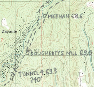
Rick Hamman, however, places Meehan slightly to the north of Doughertys, and notes a significant narrow gauge spur branching off from the mainline, which matches the suggestion in the image to the north. However, the Dougherty Mill on Hamman's map places the actual mill in the Zayante Basin, in fact located almost on top of East Zayante Road. The skid-rows shown behind the mill are what lead into Newell Creek basin, though Hamman's map does not show these leading into that valley, instead keeping the route alongside Zayante. The station, according to Hamman, was located just north of the Eccles Tunnel, branching away at Laurel Way or, possibly, Western States Drive. Cement workings in Zayante Creek in this region could possibly date to this time, though their survival over 130 years makes that seem unlikely.
Citations:
- Clark, Donald Thomas. Santa Cruz County Place Names: A Geographical Dictionary. Scotts Valley, CA: Kestrel Press, 2008.
- Hamman, Rick. California Central Coast Railways. Otter B Books, 2002.