Quantcast
Channel: Santa Cruz Trains
Viewing all 489 articles
Browse latest View live

Loma Prieta

$
0
0
A lumber company has to have some excellent connections to be able to convince a massive railroad company to build a dedicated branch line directly to its mill. Yet that is precisely what happened with the Loma Prieta Lumber Company in 1882. Granted three members of the board of directors of the new lumber company were major financiers of the Southern Pacific Railroad, but it still was an unusual feat, especially for Santa Cruz. Previously all railroads in the county had multiple patrons: this would only have one, at least initially. To do things properly, the Loma Prieta Railroad Company was founded first as an independent standard-gauged railroad, and the Southern Pacific took it over in 1887 once more direct funding was required to sustain the mill and track. The track followed Aptos Creek closely until its junction with Bridge Creek. Just south of this junction, the first major section of track terminated at the Loma Prieta Lumber Company's massive planing mill. The mill opened up for business in spring 1884.

The shingle mill at Loma Prieta, located directly behind the mill along a spur, 1888.
(Santa Cruz Museum of Art & History)
The mill was able to process 70,000 board feet of lumber per eleven-hour workday. The mill employed 150 men plus 80 contractors, decidedly the largest milling operation in the county at the time. Just above the mill, Aptos Creek was dammed to create an extremely long and meandering log pond. To the south of the mill, a quarter mile of lumber piles flanked three freight spurs. Two dedicated locomotives ferries flatcars between Molino and the mill, passing materials to another locomotive which ran between Molino and the Monte Vista mill sites further to the north.

The town of Loma Prieta with the station at right and the general store at right, c. 1890. (Santa Cruz MAH)
Loma Prieta, however, was not simply a freight stop, it was an entire town. Between the mill and Bridge Creek, and all along both banks of Aptos Creek, the village of Loma Prieta arose, catering specifically to the families of mill workers. A standard Southern Pacific depot building was erected beside the tracks, a structure that included a full-service telegraph office and passenger agency office. The community had its own hotel, general store, and business office, as well as a post office (established in 1885) and a Wells Fargo express station. By the early 1890s, over thirty homes were situated on the hillsides around Loma Prieta. The Loma Prieta School District was founded in September 1885 to cater to the children living near the camp. The railroad station was located 4 miles north of Aptos and 117 miles south of San Francisco via Pajaro Junction.

The Loma Prieta Hotel and the General Store, c. 1890. (Santa Cruz MAH)
A disastrous storm in early 1899 utterly destroyed the Monte Vista mill, forcing the Loma Prieta Lumber Company to abandon its facilities along Aptos Creek. The Loma Prieta town was abandoned and the mill dismantled. The post office closed in October 1901. In 1908, the company returned to the old mill site and constructed a new facility in the place of the old one. Three years later, the Molino Timber Company took over the mill and used it to process the timber harvested on China Ridge until 1918. In that year, the Loma Prieta Company once again took control, using the mill to process lumber harvested from high up Bridge Creek until late 1920. During all of this time, Loma Prieta was only considered a freight stop. The town had long since disappeared, taking with it the post office, general store, hotel, and many other amenities. Aptos became the new go-to town for employees needing a weekend break.

The log pond and the tracks to Monte Vista above the Loma Prieta mill (in the distance). (Santa Cruz MAH)
The site of the town of Loma Prieta today is marked with a plaque in the Forest of Nisene Marks State Park. It is north of the last parking lot along the Aptos Creek Fire Road on the east side of the creek. There is a nearby path that crosses over the creek via a bridge; this roughly marks the southern end of the lumber yard.

Citations:
  • Clark, Donald. Santa Cruz County Place Names: A Geographical Dictionary. Scotts Valley, CA: Kestrel Press, 2007.
  • Hamman, Rick. California Central Coast Railways. Santa Cruz, CA: Otter B Books, 2002.

Monte Vista

$
0
0
The Loma Prieta Lumber Company established two logging communities above its primary milling site at Loma Prieta. Both were uncreatively named the same: Monte Vista. The first Monte Vista was founded in 1883 five miles above Aptos at the end of the Loma Prieta Railroad. In the three miles that it took to get to the camp from Loma Prieta via Molino Switch, the railroad had to cross Aptos Creek five times. Two of the trestles that crossed the creek were over 200-feet long and one had a sharp bend in the middle. At Monte Vista, over 200,000 board feet of timber were cut and made into lumber at the small sawmill erected on the site. Other lumber was shipped down the grade to the larger mill to process. The first full harvest season began in 1884 and the mill at Monte Vista operated for the next five seasons as both a logging camp for the larger mill to the south and as a stand-alone milling operation.

The lumber train heading to Monte Vista, 1891.  (Santa Cruz Museum of Art & History)
Problems arose in the fall of 1886 when logging crews operating out of Monte Vista found their northward path blocked by the imposing hillsides of Aptos Creek. Despite plans to mill the miles of acreage north of the satellite mill, the company could move no further. The skid road required to reach the upper tracts of the timber field found no footing. This is why the Southern Pacific Railroad joined in and annexed the Loma Prieta Railroad, converting it into a branch line: to get to the timber further to the north. The railroad fought the so-called "Hell's Gate"—an especially narrow section of the canyon—and found a way to the land beyond. In March 1888, the route from Monte Vista to the new lumber tracts was opened, and the mill got up and relocated, taking its name with it, thereby founding Monte Vista #2.

Loma Prieta Excursion Train, c. late 1890s. (Paul Johnston Collection, MAH)
This was quite possibly the most rugged and remote sections of the Southern Pacific standard-gauged network and unfortunately few photographs of the area survive. The new camp was two miles to the north of the old one and the track hugged the west bank of the creek almost the entire stretch. The Southern Pacific Railroad included the new location in its agency books and timetables as the end of the line, placing it 120 miles south of San Francisco via Pajaro Junction. It was classified as an A-type station, which meant it had a platform and siding. A small station structure was erected there as well as numerous worker cabins and a small store for employees. Unlike Loma Prieta, this was strictly a work camp and most families lived in the larger village to the south. Monte Vista was a workers' camp, plain and simple. That being said, it was popular with tourists on weekends and, since the mill didn't run then, groups would visit the small community to enjoy the trees and dance under the stars at night. A tavern built at Monte Vista catered to both workers' and tourists' more base desires.

Only one train was assigned to work between Loma Prieta and Monte Vista, but it worked constantly each weekday, shuttling lumber and split stuff to the sidings at Molino or transferring logs to the planing mill. It was forced to backdown the canyon since there was no turntable or wye at Monte Vista, but it always ran at the head of the train to prevent runaway cars. At least two spurs branched off at Monte Vista, as well as a water tower.

Monte Vista #2 suffered terribly from a winter storm in early 1899. Hell's Gate collapsed atop the railroad right-of-way and the costs to rebuild or repair the track were deemed too much. The lumber camp was abandoned and its salvageable parts removed. Loma Prieta, in turn, was also abandoned and the company looked elsewhere for timber. The Southern Pacific Railroad pulled all the useable track between Molino and the slide, leaving the right-of-way behind to return to a state of nature. The Molino Timber Company would later come and reclaim a portion of that right-of-way to the bottom of its incline grade, but Monte Vista was gone forever. A victim of nature. Both Monte Vistas are located within the Forest of Nisene Marks State Park, at undesignated locations along Aptos Creek. The later mill site is likely no longer accessible to the public due to its remoteness.

Citations:

  • Hamman, Rick. California Central Coast Railways. Santa Cruz, CA: Otter B Books, 2002.

Claus & Farley

$
0
0
Claus Spreckels
On a lazy stretch of straight track between Rio del Mar Boulevard and Clubhouse Drive east of Aptos, the Southern Pacific Railroad set up one of its oldest sidings along the former Santa Cruz Railroad right-of-way. In later years, this would become the train stop for the Rio Del Mar community, but originally, it was put up for Claus Spreckels, the Sugar King.

Spreckels was born in Germany and immigrated to the United States in 1848. He began life as a grocery but eventually became involved in the brewing industry and, soon afterwards, sugar refining. In 1873, he began growing sugar beets in Santa Cruz County on a massive 5,380 acre property just to the east of Aptos. Five years later, he founded the Western Beet Sugar Company, headquartered in Watsonville. He was a major promoter and financier of the Santa Cruz Railroad in the early 1870s, primarily because it would link his Rio Del Mar property to the rest of the United States. However, Spreckels didn't just use his Aptos property as a farm; in 1875 he erected the Aptos Hotel on the beach near the railroad mainline. The hotel included numerous cottages and out-buildings as well as two large structures that housed a library, saloon, billiard parlor, and club-room. Numerous aquatic activities were offered, as well. A railroad siding and stop were setup on the south side of the tracks to support both Spreckel's freight needs as well as the needs of the tourists that flocked to his beach resort. However, the resort closed down in 1896 and was meticulously demolished so the wood could be used elsewhere.

The nearby railroad station was originally, if uncreatively, named "Claus". By the early 1900s, Claus was a regularly-scheduled stop on the Southern Pacific Railroad's Santa Cruz Branch line, though it is noted in agency books as being privately-owned. It was located 109.8 miles from San Francisco via Pajaro Junction and 8.5 miles from Santa Cruz. It was also 87.5 miles from San Francisco via Santa Cruz and the Mayfield Cut-Off. A 268-foot-long siding had been installed at some point prior to 1907, though when is not precisely known. Around 1907, the Claus flag-stop was renamed "Farley" in recognition of one of the largest landowners nearby: Michael Farley. Farley was an Irish immigrant who settled in Santa Cruz in around 1890. The nearby Farley Drive is also named after him. All passenger and freight trains stopped at the station, suggesting it remained a freight stop for the local farmers and ranchers even after Spreckels's died in 1908. Evidence for this continued usage is suggested by the lengthening of the siding to 567 feet—six carlengths—in 1912. Oddly, though, the stop had no facilities whatsoever, including a platform. Agency Books record it the least developed stop along the route, not even affording it a station class. In 1909, it was finally classified as type-E, which implies that it had a siding and nothing else except a sign. A platform was finally installed at the station in 1912, but it was removed in 1915, never to return.

Rio Del Mar Estates in the 1930s. (Santa Cruz Museum of Art & History)
Not long after the station was renamed, the very nature of the surrounding community changed. Most of Spreckels's land had passed to the San Christina Investment Company after his death, and that was, in turn, sold to the Aptos Beach Country Club in 1925. The organization intended to put up a resort hotel, casino, bathhouse, golf course, polo field, and small town center within the former Spreckels' family ranch. This high-class establishment had no desire to use railroad traffic and the Southern Pacific appears never to have offered it; the station was for all intent and purposes abandoned in 1921, though it remained on timetables for years afterwards. All passenger and freight service to the stop ceased. By 1926, lots in the new subdivision was named "Rio Del Mar" and began selling parcels to the wealthier public. The name means "River of the Sea" in Spanish and was a reference to Aptos Creek's outlet into Monterey Bay. Unfortunately, the stock market crash of 1929 and the resulting Great Depression ended the anticipated success of Rio Del Mar and the subdivision only slowly grew into the quiet community of today. The station, meanwhile, lingered on official timetables until the mid-1930s when the Santa Cruz Branch was reduced to its operating stops in timetables. When the siding was removed is unknown, though the tracks, now owned by Santa Cruz County, continue to pass by the site of Farley today.

Access to Rio Del Mar today is via Spreckels Drive or Rio Del Mar Boulevard off of State Route 1. Rio Del Mar State Beach is a subunit of the adjacent Seacliff State Beach. Various small businesses, restaurants, hotels, and private resorts still litter the area, intermixed with multiple waves of seaside residential settlement.

Citations:

Leonard

$
0
0
Leonard on a USGS Map, 1914.
On the barren stretch of the Santa Cruz Coast between Aptos and Watsonville, a man named Thomas W. Leonard owned a farm. The farm was nothing overly remarkable, encompassing 515 acres of the San Andreas Rancho, but it had its merits. In 1878, small deposits of gold were found near the property. This mining continued into the 1880s. The farm also happened to sit directly in the path of the Santa Cruz Railroad as its plotted its course in the early 1870s. Leonard died in 1892, but his three sons maintained the property into the 1910s.

Leonard's property was located quite close to the beach and picked up a post office in March 1883 to service the local tourist crowd. The post office closed five months later but the miniscule community became known as "Leonard's", or rather "Leonard", as a result. Since the railroad passed directly through the property, it made sense to establish a stop nearby, which was built around the same time as the post office, located 450 away. The design of the station is unknown, but it appears to have been staffed, at least seasonally. By the late 1890s, it included a 291-foot spur and a freight platform. This suggests that there was at least some local use of the station as freight. It was permanently a flag-stop, which suggests it wasn't the most popular place in town, though it also implied that passengers could use the stop to pick up trains.

The station was located 10.7 miles from Santa Cruz, 109.8 miles from San Francisco via Watsonville Junction, and 89.7 miles from San Francisco via the Mayfield Cut-Off. The stop remained in timetables until the early 1930s and stuck on agency books until World War II or later. The spur was lengthened into a 590-foot-long siding in 1912, a feature reflected on the map above. The siding was on the northeast side of the mainline track.

John Joseph Montgomery and his flying machine, 1905.
Leonard had a brief fame in 1905 when it Professor John Joseph Montgomery, a local university mathematics teacher, successfully flew the first engineless aircraft more than a year before the Wright Brothers had their flight in South Carolina. Three flights on March 16, 17, and 20th, 1905, were conducted on the property of the Leonard Family. The pilot of the flights would die the following month after a flight accident in Santa Clara. Montgomery himself died in a crash in 1911 when he hit what is today known as Montgomery Hill near Evergreen Valley College in San José. The legacy of Montgomery was quickly overwhelmed by the Wright Brothers and has yet to be adequately resurrected.

Leonard's Ranch was annexed to Seascape Beach Estates (later Seascape) in the 1969, though there remains a small agricultural parcel near the station site today. The site of the station is near the end of Summer Avenue near Seascape Park.

Citations:

  • Clark, Donald. Santa Cruz County Place Names: A Geographical Dictionary. Scotts Valley, CA: Kestrel Press, 2007.

Manresa & Robroy

$
0
0
Manresa on a 1914 United State Geological Survey map.
In 1894, the College of Santa Clara opened along a stretch of Monterey Bay coastline a Catholic retreat called Villa Manresa. The name was a reference to Manresa, Spain, where Saint Ignatius of Loyola recovered from wounds received at the Battle of Pampeluna. While recovering there, he first conceived of the ideas that formed the backbone of his Society of Jesus (the Jesuit order). For the next thirty years, Villa Manresa was an isolated location, accessible only via San Andreas Road and the Southern Pacific railroad.

The railroad, which passed directly through the property on its branch between Santa Cruz and Watsonville, first established a stop at Manresa around 1907. It was located above the beach and just south of the Manresa Beach railroad bridge. The station had no services, no station structure or platform; it only had a sign. The stop was 90.4 miles from San Francisco via the Mayfield Cut-off, 11.5 miles from Santa Cruz, and 8.6 miles to Pajaro Junction. It never had regularly-scheduled passenger service but was retained only as a flag-stop.

Manresa did, however, have a 129-foot-long spur which was installed around 1907. What it was used for the first thirteen years of its existence is unknown, but beginning in 1920 it was used by the Ferro Products Company to ship out its products. The company mined iron oxide from the sands nearby and built a refinery beside Villa Manresa. The spur beside the factory was extended to 279 feet in 1912 and was extended again to an unknown length in 1920. A platform was also installed in 1912. How long Ferro Products operated at Manresa is unknown; the company was reorganized in 1921 and may have abandoned the site soon afterwards. The last mention of the facility at Manresa is in March 1923.

The Manresa property was divided in two in 1925 and the bulk of it was sold to David W. Batchelor who turned it into his Rob Roy resort and residential subdivision. Batchelor was Scottish and wanted to name the community after the famous Highland outlaw Rob Roy; the street names also were all Scottish in nature. The 270-acre property was extensive and included a private beach, a bath house, a deer park, a dance pavilion, bridle paths, hiking trails, and seasonal cottages, in addition to permanent residential homes. The local Hill School relocated to Rob Roy in 1932, marking the community's transition from a resort into residential area. The nearby railroad stop was renamed Robroy—all one word—in 1926 to reflect the change in ownership. Passenger service to the subdivision seems to have never have taken off and it ended by the early 1930s. The station was removed from Southern Pacific Railroad agency books only in 1940.

The Rob Roy subdivision did not thrive in the Great Depression and was eventually bought out in 1935 by Edward G. Burghard who renamed the community La Selva Beach, a reference to the forests that speckle the hills above the beach. The school became the La Selva Beach School in 1936, merging into the Aptos School District in 1942, and a post office was established for the community many years later in 1952. Railroad service only existed at La Selva Beach until 1938 when passenger service along the entire branch line ceased. The tracks, however, continue to pass through the community even today, rarely used since 2011. The adjacent 21-acre beach became Manresa State Beach in 1948 and is no longer the exclusive purview of the La Selva locals. The site of the station is at the bottom of Margarita Road while the spur stretched from that point to the bottom of Playa Boulevard.

Citations:

  • Clark, Donald. Santa Cruz County Place Names: A Geographical Dictionary. Scotts Valley, CA: Kestrel Press, 2007.

Cristo

$
0
0
For most of its existence, the Manresa stop stood alone between Leonard and Ellicott. But in 1918, a firm under the leadership of Donald M. Crist and Irving Carl called the Ferro Products Company established an iron processing plant on the hills above Manresa Beach. The land they purchased had previously been owned by the College of Santa Clara, a Catholic institution that eventually became the University of Santa Clara. The beach, then known as Zils Beach after its original owner, Peter Zils, was known for its black sands, rich in magnetite which was used to make sponge iron and steel alloys. Almost immediately, the new firm was sued by a local, Henry Goetz, who complained that Crist and Carl dumped its refuse material on the surrounding countryside. The partners won the case since they owned the property. Soon afterwards, they began increasing their productivity and petitioned the Southern Pacific Railroad, whose Santa Cruz Branch passed directly in front of their facility, for a siding and stop.

The "Playland Special" near Rob Roy and Cristo, overlooking Manresa Beach, May 28, 1939. The building in the background is the Ferro Products Company refinery. Photo by Wil Whittaker. (Jim Vail Collection)
Initially, the company appears to have used the nearby Manresa station to ship out its product. But upgrades to the facility in late 1920 prompted the railroad company to dedicate a special siding just for the facility. Thus "Cristo"—named after Crist—became a stop in June, 1921, located 90.8 miles from San Francisco via the Mayfield Cut-Off and 8.4 miles from Watsonville Junction. A freight-loading platform was built for the firm on the northeast side of the tracks. The siding was small, only long enough for three cars. Passenger service via a flag-stop was maintained for local commuters, though it was not listed on the non-commuter schedules. By the mid-1930s, the stop had been removed from timetables except as a casual flag-stop, which means it was footnoted as an additional stop outside of the standard timetable. The station did not have any other facilities and appears to have mostly been a freight stop, despite the option of a passenger stop.

The Ferro Products Company became the Ferro Products Corporation in late 1921, with new corporate offices installed in San Francisco and the company passing under the management of D.C. Jackling. The president of the new company, A.J. Maclean,  took over for Don Crist, while Crist became general manager. The company became a branch of the Triumph Steel Company in early 1925. In 1932, the company shifted to creating stainless steel at a new $150,000 steel plant erected on the site of the old iron plant. Meanwhile, the Triumph Steel Company became the American Alloy and Steel Company.

The railroad siding continued in agency books as late as 1941, after which this historian's records do not extend. Problems with the facility upgrade in 1932, at the height of the Great Depression, may have ended the company's presence in Santa Cruz County as newspapers no longer record the company or Crist after October 1932. It is likely the company left Santa Cruz at around the time, abandoning the siding. In this case, the Southern Pacific simply left it in its agency books, awaiting a time when those books would be cleaned of abeyant stops.

Citations:

  • Clark, Donald. Santa Cruz County Place Names: A Geographical Dictionary. Scotts Valley, CA: Kestrel Press, 2007.

San Andreas & Ellicott

$
0
0
Ellicott on the Southern Pacific line, 1914. (USGS)
Rancho San Andrés, frequently spelled San Andreas (named after the Apostle St. Andrew), was one of the many Castro family properties in Santa Cruz County during the Mexican era of California history. The rancho sat between Manresa Beach to the northwest and Sunset Beach to the southeast. The original land grant was issued in November 1833, one of the first issued in the county, but the property had likely been called San Andrés since the 1820s. When statehood was achieved in 1850, the San Andreas Ranch became a small community along the coast, isolated from its neighbors. Around twenty different businesses were present in the area in 1875 and the settlement had its own school, established in 1861 and consolidated into the Freedom district in 1946. When the Santa Cruz Railroad passed through the area, it is likely a stop was established for the residents. By 1889, after the Southern Pacific acquisition of the line and the line's broad-gauging, a more formal "San Andreas" station was installed. The station was located 107.1 miles from San Francisco via Pajaro Junction and 13.4 miles from Santa Cruz. It had regular passenger service to the site via a flag-stop beside the track. 


A double-header cruising southeast near Ellicott, April 25, 1949. (Wilbur Whittaker Collection)
On January 1, 1892, San Andreas Station became Ellicott, a name of unknown origin. The reason for the change was because there was already a San Andreas Station in the Southern Pacific system. The name of the community changed soon afterwards. When the Mayfield Cut-Off was completed in 1909, the station became 92.5 miles from San Francisco. The stop was a full freight station with at least one siding located on the southwest side of the mainline, and a platform. The siding and any nearby spurs measured a combined 421 feet in 1909. The available siding track was lengthened to 640 feet in 1911. The next year, it was extended again to 936 feet. Ellicott and San Andreas appear to have been primarily an agricultural stop. The Southern Pacific's station in the area until it burned down in January 1906 was a large warehouse. From 1903 to 1906, it was leased to John H. Covell who stored hay in it on behalf of local farmers. The stop is little mentioned after the destruction of the warehouse and it seems to have become more of an informal freight stop thereafter. Around the start of World War II, the US National Guard unit stationed at Camp McQuaide had an access road installed to Ellicott Station from their base in Capitola. Presumably Ellicott offered the best siding access for the loading and unloading of military equipment, despite the fact that the station was many miles away from the camp. This arrangement ended in the early 1950s.

Though regularly-scheduled passenger service along the line had ended in 1938, Ellicott was still an active freight station at the time World War II started in late 1941. When it was finally abandoned as a stop is not presently known by this author, though the last mention of the station in newspapers is in 1973. The location of the stop was just north of the junction of San Andreas Road and Buena Vista Drive near Freedom.

Citations:

  • Clark, Donald. Santa Cruz County Place Names: A Geographical Dictionary. Scotts Valley, CA: Kestrel Press, 2007.

Laguna & Nuga

$
0
0
1914 USGS map showing Nuga deep in the sloughs of Watsonville.
Not far from Watsonville, mired in the sloughs that populated the western part of that city, the Santa Cruz Railroad setup a small agricultural freight stop for the Martin family named, conveniently, "Martins". The station was established on July 1, 1876, making it one of the first scheduled stops on the new railroad's line. It was located next to Watsonville Slough between the outlets of Hanson and Harkins Sloughs. It had direct access to the Watsonville Beach Road (W. Beach Street) and the Port Watsonville pier. What precisely Thomas, William, and R. Martin did on their property is not entirely clear; the area was known for its pastures and ranch land so it can be surmised that they engaged in a similar endeavor.

The stop became "Laguna" at some point in the 1890s. By this time, a 1,528-foot-long siding had been installed on the south side of the mainline track and running most of the length of the property. The station is recorded in timetables as having full passenger and freight service in the early 1900s, though the station became a flag-stop after 1909, retaining scheduled freight service. The station was located 3.7 miles north of Pajaro Junction (later Watsonville Junction) and 103.8 miles from San Francisco. After the completion of the Mayfield Cut-Off in 1909, the distance to San Francisco was reduced to only 95.6 miles. In that year, Laguna received a strange name change: the name was inverted and the first and last letters dropped, creating the station name "Nuga". It retained this name the the remainder of its existence.

Nuga had its siding extended to 2,065 feet in 1911 and 2,553 feet the next year. By 1913, it was capable of holding 39 freight cars on its track, which is not an insignificant trackage. A platform was added for the station as well in 1912, though no other services were installed at the site. Over the following twenty years, the siding shrunk down slightly to support only 33 cars and its status was demoted to that of a passing track, suggesting that by June 1941, the location no longer required regular freight service. Considering the high concentration of agricultural produce in the area, it can be supposed that Nuga was simply an agricultural freight stop, but its original status as a passenger station suggests that it may have had another function originally as well, possibly as an early jump-off point for streetcars running to Watsonville's pier and Camp Goodall at the beach, or for students of the nearby Beach School. Alternatively, one newspaper in October 1909 suggests that it was an aggregate collection site.

One interesting note about Nuga is that it was the lowest point on the entire Southern Pacific branch line, being only 8 feet above sea level. The tracks often flooded here from ocean swelling as well as the sloughs, which brought in debris from the hills. Whenever the Santa Cruz Branch sustained storm damage, Nuga was one of the places worst hit, with the tracks often flooded under feet of water.

Nuga was abandoned by the Southern Pacific Railroad in March 1957. No photographs of this station have been forthcoming. The location of the station was along the tracks at the last curve before entering the Watsonville freight yard from the north. The nearest road is W. Beach Street but the original access road to the station has since been turned into agricultural fields.

Citations:

  • Clark, Donald. Santa Cruz County Place Names: A Geographical Dictionary. Scotts Valley, CA: Kestrel Press, 2007.

Watsonville Depot

$
0
0
USGS Map of Watsonville, noting the station, from 1914.
The history of an entire city is truly beyond the scope of a single article, and this historian will not attempt it here. These articles focus first and foremost on individual railroad stops, and that is how Watsonville will be treated. Other articles will expand on the Watsonville freight yard and its importance to Santa Cruz County, especially after the turn of the century. This article, however, is about a rather important, but not spectacularly so, station near the southeastern end of the Southern Pacific Railroad's Santa Cruz Branch.

Watsonville was devised by Judge John H. Watson and D.S. Gregory on 5,496 acres of land illegally seized from Sebastian Rodriguez, owner of Rancho Bolsa del Pajaro in 1851. The rancho was a Mexican land grant awarded to the Rodriguez family and in its initial years it was called Rancho Bolsa de los Rodriguez but it was later named after the abundance of seabirds (los pajaros) that nested in the sloughs around the property. The first American settlers arrived in 1852 but it would be more than a decade before the town formally came into being. In this time, a few major road arteries were put in place, primarily Pajaro Street (soon renamed Main Street), and the Santa Cruz-San José turnpike. The Pajaro River to the southeast established the towns boundary there, while nearby sloughs kept the town relatively boxed in. Watson and Gregory did not initially name the town "Watsonville", but rather called it "Pajaro", after the river. A local sheriff deputy, H.F. Parsons, is generally considered the person who named the community after Watson, calling it in a police report "Watsonville". Watson moved to Idaho in 1865 and never returned, but the town adopted his name when it was incorporated on March 30, 1868. The town's first post office (and the second in the county) was established there in November 1853, though under what name is not certain. The first school in town opened that same year in a private house, with a permanent schoolhouse erected in 1864. A high school was later erected nearby in 1894. The town later became the City of Watsonville in 1903.

A Claus Spreckles wagon down the tracks from Watsonville Station, c. 1880s.
[Margaret Koch Collection – Santa Cruz Museum of Art & History]
Railroading and Watsonville were early companions. A year before the town was incorporated, the California Coast Railroad Company was incorporated to connect Gilroy and Watsonville together, thereby bringing Gilroy in contact with the sea, and Watsonville in contact with the Santa Clara Valley. Frederick Augustus Hihn was an investor in this early line and would continue to invest in local railroading ventures into the 1870s. He desired nothing less than to control the means of shipping out lumber from Santa Cruz County. In March 1868, the San Francisco & San José Railroad merged with the Santa Clara & Pajaro Valley Railroad (originally the California Coast Railroad), thereby forming the Southern Pacific Railroad Company. The Southern Pacific's long-term goal was to reach deep into the Central Valley and eventually to Arizona where it would connect with a transcontinental route. A few months afterwards, the Southern Pacific absorbed the Central Pacific Railroad, thereby becoming the largest railroad company on the West Coast.

Watsonville entered the game in 1870 when the California Southern Railroad Company, a subsidiary of the Southern Pacific, sought to connect Gilroy to Salinas via Watsonville on a 45-mile-long track. In the second half of 1871, the line was completed, but it did not pass through Watsonville as planned, but instead remained on the south bank of the Pajaro River, at the small community of Pajaro. While locals now had access to the railroad, they had to cross the county line to get their wares to the trains. The situation was problematic, but manageable.

A patriotic celebration at the station on July 23, 1916. [Santa Cruz MAH]
But Frederick Hihn and the residents of Santa Cruz were not happy. They demanded to have a railroad that went all the way to Santa Cruz. In 1872, the Santa Cruz & Watsonville Railroad was founded to meet this need. Initially, funding fell through and agreements with outside lines fell apart. The company was reincorporated in September 1872 as the Santa Cruz Railroad; it would be locally built and narrow-gauged, but it would bring the railroad through Watsonville to Santa Cruz. Financial panic the next year stalled progress but it began in ernest in mid-1873. Watsonville, however, who voted against the railroad and saw no need for it suddenly found itself locked out of negotiations, with grading crews wrapping the track west of the city, thereby bypassing it. In December 1874, the town sued the railroad, stating that they had reneged on terms from 1873. The proposed "Watsonville Station" was not close enough to the city to meet the terms of the agreement. The court agreed with Watsonville and the track was realigned to run closer to Watsonville.

Construction progressed rapidly from both ends. The initial construction had begun in Santa Cruz heading toward Watsonville, while bridgework on the Pajaro River bridge began as soon as the dust settled on the issue of where to align the track near Watsonville. On May 7th, 1876, the railroad line finally opened to the public, with Watsonville the first stop on the northern run to Santa Cruz. The Santa Cruz Railroad went through a turbulent five years before finally being acquired by the Southern Pacific in 1881. Soon afterwards, the tracks were completely overhauled and standard-gauged, allowing them to compete somewhat with the narrow-gauged South Pacific Coast route over the Santa Cruz Mountains.

Watsonville Station on October 6, 1946. Passenger service has ended and the station only services freight and local bus connections. Mainline service continues across the Pajaro River at Watsonville Junction. [Wilbur Whittaker Collection]
Watsonville, in this long story, remained an important lynchpin in the plan. Besides acting as the southern base of the county, the route through Watsonville to San Francisco also remained shorter until the completion of the Mayfield Cut-Off in 1909. Freight sent via this route got to San Francisco faster generally if sent from south of Santa Cruz. Watsonville was located 101.8 miles from San Francisco via Pajaro Junction, 18.4 miles from Santa Cruz, and 1.8 miles from Pajaro Junction. The station served as the western terminus of the Pajaro Valley Consolidated Railroad, a narrow-gauged route that ended outside of Salinas and operated from 1890 until 1929. The station had 20,485 feet of siding and spurs, many of which went to local businesses that maintained partnerships with the Southern Pacific Railroad and will be discussed in other articles. After 1909, the station was 97.5 miles from San Francisco via the Mayfield Cut-Off. The station provided passenger, freight, Railway Express Agency, and telegraph service, and was a major switching point for local trains running between Santa Cruz and Watsonville. It also featured access to the local streetcar line that ran down Beach Street to the Watsonville Wharf and Camp Goodall.

A Google StreetView photograph of the station today from almost exactly the same angle as the photograph above it. Little has changed, but the windows have been boarded up or sealed and the structure has been used irregularly as a local business center or commercial building. [Google StreetView]
Passenger service at Watsonville Depot ended in 1938, but freight service continued until very recently. Suntan Specials, as well as other excursion trains, ran continuously through to 1959, after which they became less common, disappearing entirely after 1965. Spurs to various local freight concerns still exist today around the site of the depot. The depot, meanwhile, has survived all this change and remains at the junction of West Beach Street and Walker Street. The remnants of a few spurs can be found in the asphalt near the station while pieces of historic siding run all the way down Walker Street on both ends, misperceived today as parking stops but once freight loading locations. Santa Cruz County now owns the right-of-way in this area and passenger service may well resume in the coming years as the Santa Cruz & Monterey Bay Railroad attempts to restart all types of service along the line, with Watsonville being one of the major planned stops.

Pajaro & Watsonville Junction

$
0
0
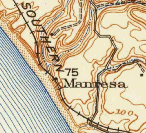
Watsonville Junction on a 1915 USGS Map.
Just beyond the southeast corner of Santa Cruz County, the small town of Pajaro sits unassuming as it has since the 1870s. This place was named after the adjacent Pajaro River, which separates Santa Cruz from Monterey County. It is a relatively short, though surprisingly wide, river named by the company of Don Gaspar de Portola on October 8, 1769, after a dead stuffed California condor that was found on its banks. Portola had in fact named the river Rio de la Señora Santa Ana, but nobody has ever really called it that. For many years, the name leant itself to the communities on both sides of the river. The northern community would eventually evolve into Watsonville, but the southern town kept its name.

In 1871, the Southern Pacific Railroad Company, through its subsidiary the California Southern Railroad, built a line between Gilroy and Salinas, passing through Pajaro on its journey. Since it stuck to the southern bank of the river, it never crossed into Santa Cruz County (except further to the north briefly), a fact that never changed. Indeed, even today the mainline of the former Southern Pacific Railroad passes through the town on its way down the Salinas Valley to San Luis Obispo and Los Angeles. For five years, from 1871 to 1876, the people of Watsonville were content with their railroad service across the river. Sure it was a slight bother to have to cross the river beside the railroad's bridge, but they got their goods to market without much fuss. It was the rest of Santa Cruz County that wanted railroad access, the people of Watsonville felt that they already had it.

Nonetheless, in 1876, a connection across the river was finally completed and Pajaro became the junction for the private Santa Cruz Railroad line and the Southern Pacific mainline. In 1881, the latter bought the former and they became a united track in 1883 when the Santa Cruz tracks were standard-gauged. In a brief few years, Pajaro had gone from a rural farming community to a major hub on a intra-California railway network.

Located 100.4 miles from San Francisco via Gilroy and San José, Pajaro Junction, as it was informally called, came to encompass the full spread of Southern Pacific services. It hosted a wye, a turntable, a massive water tower, a large roundhouse for engines and cars to park in, a freight and passenger depot, multiple platforms, tens of thousands of feet of siding and spur space, and telephone services. It was the largest railroad transfer station in Santa Cruz County area, even though it was technically outside the county. With the Pajaro Valley Consolidated Railroad sending excess freight in from Watsonville and the Monterey Branch also bringing in freight from the south, the junction became the heart of the local railroading scene. Its elevation in the late 1890s eventually caused the loss of maintenance and repair facilities at Santa Cruz because there was simply more space at Pajaro and its location just warranted its relocation. Thus by 1900, Pajaro was the railroading hub of the region. Most of the lumber traffic from Aptos traveled via Pajaro, while even loads of lime from Santa Cruz was just as likely to go via Pajaro as via the mountain section. Just to give an estimate of how much space was available there, in 1911 Pajaro had 19,375 feet of siding space. Two years later, it had 34,813 feet. Maps of Pajaro are difficult to even interpret the number of sidings, with them just merging together as a black blob. Two tracks led out from Watsonville to the north to Logan, while another pair of tracks led south to Elkhorn. Only one track crossed the Pajaro River into Santa Cruz.

Watsonville Junction, two months after the closure of the mountain section, April 28, 1940. (Wilbur C. Whittaker)
The station at Pajaro was typical Southern Pacific design, with gabled ceilings, a bay window that served as the ticket office, and interior and exterior seating. The freight depot was next door in a more simple rectangular building with a short peaked roof. Tracks wrapped around the structures from all sides, with various outbuildings nearby for railroad crews and support staff. The station was never a major passenger stop, since there were no resorts nearby and few residents living in Pajaro, but passenger trains passed through multiple times daily on their runs to Santa Cruz, Monterey, Los Angeles, and San Francisco.

In early 1913, Pajaro was renamed Watsonville Junction. The reason for this relabelling is not known, but it certainly boosted the status of Watsonville, which was right across the river. It may have been acknowledging that urban sprawl occurring on both banks of the river, though the area immediately around Watsonville Junction was still mostly outside the residential areas of Pajaro. Watsonville was 1.4 miles away, so it wasn't just a short crossing of the bridge, there was a distance there. Legally, the area immediately around the junction was renamed as well and registered as an unincorporated area of Monterey County, but it is generally considered a part of the town of Pajaro. Just prior to this renaming, the Mayfield Cut-Off opened, thereby shortening the distance between Watsonville Junction and San Francisco by 1.2 miles, albeit over the mountain section, which was more difficult to navigate for longer or heavier trains. The change in distance, though, may have slightly lessened the importance of Pajaro, however, since passenger trains that may have once routed through there could reroute through the mountains and arrive slightly more quickly to Santa Cruz (about 30 minutes, according to some account).

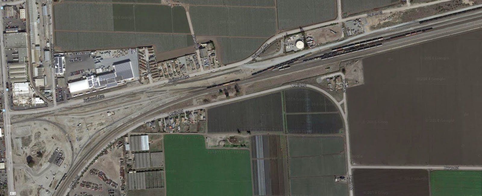
Google Maps satellite view of the freight yards at Watsonville Junction.
Unlike all the stops in Santa Cruz County, the Watsonville Junction still exists, though in a seriously reduced capacity. The end of passenger service on the Santa Cruz Branch in 1938 did not end Watsonville Junction's status as a station for trains passing between San Francisco and Los Angeles. Passenger trains still occasionally pass through the station today, though few would realize that it was ever once anything more than a freight stop. Today, five sidings, three spurs, and three track transfers, as well as the wye, remain in place, with the visible remnants of many more still imprinted behind.
All facilities, though, have been removed, including the station, the roundhouse, and the turntable. The imprint of the turntable and roundhouse can be discerned on Google Maps overhead views, a concrete platform still sits nearby. The mainline track and the Santa Cruz Branch (now owned by Santa Cruz County) still split at the site, but no local businesses require spurs nearby and the junction has today full embraced its status as just that, a meeting place between tracks. With the improvements to the Santa Cruz Branch, one hopes that connections will once more resume with the Union Pacific (successor to the Southern Pacific), but that is still probably many years away. Until then, Watsonville Junction remains a dot on a map, an otherwise forgotten relic of a time when railroads were the primary means of shipping freight and transporting people.

Santa Cruz Trains is coming to your doorstep this March!

$
0
0
February 26, 2015, Felton, CA

On this day 75 years ago, the last train ran over the Santa Cruz Mountains. Celebrate the railroad's history with Santa Cruz Trains: Railroads of the Santa Cruz Mountains, a 352-page book of articles and photographs surveying the history of the communities that interacted daily with the railroads. The period spanned by this survey includes virtually the entirety of Santa Cruz and Los Gatos history, from the 1850s to the present. Each article discusses a specific community, business, or geographic location and is supported with full citations and references, maps, historical advertisements, and over 200 photographs, many of which have never before appeared in print.

While it had originally intended to see a digital-only release for 2015, the book will now be released as a soft-bound volume, available from CreateSpace in March. An e-book edition is currently on hold, pending further development.


From the back cover:
Once there was an endless redwood wilderness, populated by only the hardiest of people. Then, the sudden blast of a steam whistle echoed across the canyons and the valleys—the iron horse had arrived in the Santa Cruz Mountains. Driven by the need to transport materials like lumber and lime to the rest of the world, the railroad brought people seeking out new ways of living, from the remote outposts along Bean and Zayante Creeks to the bustling towns of Los Gatos and Santa Cruz. Bridges and tunnels marked the landscape, and each new station, siding and spur signaled activity: businesses, settlements, and vacation spots. Summer resorts in the mountains evolved into sprawling residential communities which formed the backbone of the towns of the San Lorenzo Valley today. Much of the history of the locations along the route has since been forgotten.  
This is their story.
Derek Ryan Whaley is a local historian and recent resident of Felton, California. His research on local railroads began in 2011 after attending a seminar held at UC Santa Cruz by Brian Liddicoat. From there he started his website, www.SantaCruzTrains.com, which eventually led to the writing of this book. Derek has been involved in the Santa Cruz historical community since 2012 and is currently researching for his PhD in History at the University of Canterbury in Christchurch, New Zealand, from which he plans to graduate in 2017. His local railroad website is updated every Friday with new content relating to the local railroads and their history.

For more information, or to get in touch with the author, please email author@santacruztrains.com.

Chittenden

$
0
0
In the remote fringe of Santa Cruz County, buttressed between high mountains and closer geographically to Santa Clara County as it is to Watsonville, the small community of Chittenden sits beside Soda Lake. Of all the railroad stops in the Santa Cruz County, this is the most isolated for it is the only county stop of the Salinas Sub-Division of the Southern Pacific Railroad and it is surrounded to the north by stops within Santa Clara County and stops to the south within Monterey and San Benito Counties. It stands apart from every other railroad station.

Map of Rancho Salsipuedes, 1853. (UCSC Special Collections)
Nathaniel W. Chittenden unintentionally leant his name to the stop when he settled in what became known as Chittenden Pass around 1870. He had been until that time a lawyer from San Francisco. When he moved to Santa Cruz County, he purchased the eastern corner of Rancho Salsipuedes. The rancho had a long and disputed history, with its origins in a possible land grant to Mariano Castro in 1807, making it one of the few Spanish, rather than Mexican, land grants in the county. It was the second largest rancho in the county, as well, measuring 25,800 acres. Because of its large size and its disputed status, it was one of the first ranchos that was divided up following the American annexation of California. Its last Mexican owner was Manuel Jimeno Casarín. The soil of the rancho as a whole, but especially within the pass between the mountains, is highly fertile and the alkaline Soda Lake, the only such lake in the county, was a source for mineral collection. The road that passed through the pass became a county road in 1894 and it remains one of the primary means of passing between Santa Cruz and Santa Clara Counties even today. Chittenden died in Watsonville in 1885, after which his lands were divided between his kin. Idea H., Clara, and Talman Chittenden were some of his beneficiaries.

The Chittenden community center, showing a small general store, c. 1900. (Santa Cruz Public Libraries)
El Pajaro Springs postcard, c. 1910. (CardCow.com)
Chittenden as a settlement was never impressive—numbering fewer than 80 in 1893. The small community that lived in the gap still managed to establish a post office in April 1893 and kept it for many years. The railroad station was probably established around the same time under the name "Chittenden's", and later dropping the "s". One of the reasons why it lasted for as long as it did may have been because of the Chittenden Springs resort that was established beside a sulphur hot spring in the gap. In 1906, the Chittendens sold the spring to A.F. Martel who renamed it El Pajaro Springs, a reference to the Pajaro River that still passes through the gap. In 1918, it was sold again to the St. Francis Hospital of San Francisco and it became St. Francis Springs. The resort was near Soda Lake and the train station. That area had been popular since at least 1894 when the Watsonville Pajaronian reported a picnic at the site.

Chittendent passenger shelter and freight platform with boxcars on spur, 1908. (Santa Cruz Public Libraries)
1906 San Francisco Earthquake damage at Chittenden.
(Granite Rock Company)
The railroad stop at Chittenden was primarily for freight. Passengers could use the facility as a flag-stop, but no agency office was available there to purchase tickets. A small covered patio was provided for passenger use. Chittenden was 91.9 miles from San Francisco via the mainline track through San José, and it was 28.6 miles from Santa Cruz. It included 123 car lengths of siding and spur space, which may or may not have included a special track to Soda Lake, where a mining firm was always attending to the lake's minerals. The siding at Chittenden ran along the north side of the tracks, between where the tracks are today and State Route 129, branching off near the first major driveway over the tracks and merging just before where the highway crosses under the tracks. The spur to Soda Lake, if there was one, is still be visible today as a dirt road to the lake branching off from the highway.

Chittenden's small post office building with a man posing out front, 1900. (Santa Cruz Public Libraries)
Boxcars damaged by the 1906 San Francisco Earthquake, at Chittenden.
(Granite Rock Company)
Chittenden as a community still exists, but the presence of large nearby cities and the ease of accessing those cities has rendered the village of Chittenden non-existent. The post office was the first to close, shutting its doors on June 15, 1923. The railroad station lasted until the U.S. entry into World War II, when it closed on April 7, 1942. The stop remained on timetables, though, for another decade as a freight stop and waypoint, being removed at some point in the mid-1950s. El Pajaro Springs is surprisingly still listed on Google Maps as a site to the west of Soda Lake, but no structures appear in the area. While the area is still certainly a population center, it is classified as unincorporated Santa Cruz land and there is no real commercial district at Chittenden today.

Citations:
  • Clark, Donald. Santa Cruz County Place Names: A Geographical Dictionary. Scotts Valley, CA: Kestrel Press, 2003.

Logan

$
0
0
Logan on a 1915 USGS Survey Map.
The history of Logan is a history of the Granite Rock Company. When the Southern Pacific Railroad first set up its track between Gilroy and Pajaro in the early 1870s, it discovered a large granite outcropping on the southern bank of the Pajaro River just on the Monterey Bay side of Chittenden Pass. For the first twenty years after its discovery, local firms operated out of the quarry, hauling out their crushed granite at Logan Station, a nearby freight railroad station. In 1899, a group of local investors purchased the 27-acre quarry for $10,000 and incorporated on February 14, 1900, as the Granite Rock Company.

A freight car parked at Logan near the crushing plant.
(Granite Rock Company)
From the very beginning, the Southern Pacific and the quarry at Logan had a relationship. As construction of the Salinas Subdivision line continued into the Salinas Valley, crushed granite from Logan was used as ballast for the railroad cross-ties. Sledge hammers and ox carts were used to get the ballast down to the station for shipment. An insular mining tram system was soon developed throughout the quarry to ease the transport of rock. Beside the mainline track, a long siding was installed for use by Granite Rock. A rock crushing plant was installed beside the siding while rocks were dropped in the top. Processed granite was loaded onto waiting freight cars below.

The 1906 earthquake heavily damaged the facility, leveling the crushing plant and forcing an almost complete rebuild, but the simplicity of the operation meant it was back in operation the next year, providing granite for the rebuilding of San Francisco as well as the erection of the Santa Cruz Beach Boardwalk's Casino. Following the earthquake, quarrying moved deeper into the property and a small locomotive called the "Dinkey #1" was purchased to shuttle mine cars between the quarry and the crushing plant.
The ruined crushing plant after the San Francisco Earthquake, 1906.
(Granite Rock Company)
In the 1920s, the company helped build the adjacent Highway 129. In the 1930s, the first asphaltic concrete plant in California was erected at Logan beside the crushing plant. The quarrying operations at Logan continued to increase in the following decades. By 1970, 7,500 tons of granite rock were being shipped out per day from Logan, which were shipped on 25 100-ton hopper freight cars purchased by Granite Rock Company. Graniterock strongly believed in the value of shipping via rail, an aspect of freight transport that was losing popularity by the 1970s. In 1989, Graniterock completely remodeled its facilities at Logan, renaming the site the A.R. Wilson Quarry. The quarry still operates today off of State Route 129 northeast of Watsonville. The "Dinkey" engine was heavily restored and donated to the California State Railroad Museum.

The Logan plant is now more solidly associated with the nearby town of Aromas, where most of the quarry's staff have lived over the past 110+ years. The name "Logan" itself has largely disappeared and its origin is not known to this historian.

The Logan station point, July 31, 1949, crushing plant at right. (Wilbur C. Whittaker)
Official Railroad Information:
The crushing plant at Logan from the air, with the sidings in front, 1951.
(Granite Rock Company)
Railroad records are fairly complete regarding Logan, but unfortunately they are not complete for this historian. The earliest record possessed by this historian shows Logan on a Officers, Agencies & Stations Book entry in 1899 listed as between Chittenden's and Aromas, at mile marker 93. It had a class-A freight status, meaning it had a platform, which was located on the right (southeastern) side of the tracks. No other services were listed that year.

The Logan station point was 93.2 miles south of San Francisco via San José and the San Francisco Subdivision. It was 7.2 miles north of Watsonville Jct. (Pajaro). Logan was the northern start of a double-track that continues today to Watsonville Jct. In 1940, Logan had no recorded spur, just the double-track. It offered regularly-scheduled passenger and freight service to and from the stop, as well.

Passenger service is no longer provided at Logan and, indeed, the stop's current name on Union Pacific timetables is not known to this historian. It was still under the name "Logan" in 1987. However, the station is certainly still active. Google Maps show that the tracks beside Logan are still in use and that there are at least four sidings beside the mainline as well as at least five in-use spurs. More may be buried beneath loose gravel or are not visible on the maps.

Geo-coordinates and Access Rights:
36˚N 54' 2.857" x 121˚W 38' 2.591"

Logan is still owned and operated by the Granite Rock Company and access is by permission only.
The Logan facility in 2013, still in use though parts of it are falling into disrepair, no longer used by Graniterock.
(Wikipedia)

Citations & Credits:


Santa Cruz Trains Book Now Available!

$
0
0
History Buffs Eager for New Santa Cruz Trains Book

Link to Book: https://www.createspace.com/5330016

March 12, 2015

Santa Cruz, CA

The wait is over for Santa Cruz history fans: local historian Derek R. Whaley’s Santa Cruz Trains: Railroads of the Santa Cruz Mountains has just been published as a soft-bound book through CreateSpace. The extensive 330-page book commemorates the 75th anniversary of the last train over the Santa Cruz Mountains and spans almost the entirety of Santa Cruz and Los Gatos history, from the 1850s to the present. Each article discusses a specific community, business, or geographic location linked to the railroad and is supported with full citations and references, maps, historical advertisements, and over 200 photographs, many of which have never before appeared in print. Article topics range from the well-known stations like Boulder Creek and Big Trees to such remote places as Call of the Wild on Los Gatos Creek and the Summit Tunnel.

“This book is the result of over two years of research and the support of many local community members who have provided information and photographs related to the railroad’s presence in Santa Cruz,” says author Derek R. Whaley.

From the back cover:
Once there was an endless redwood wilderness, populated by only the hardiest of people. Then, the sudden blast of a steam whistle echoed across the canyons and the valleys—the iron horse had arrived in the Santa Cruz Mountains. Driven by the need to transport materials like lumber and lime to the rest of the world, the railroad brought people seeking out new ways of living, from the remote outposts along Bean and Zayante Creeks to the bustling towns of Los Gatos and Santa Cruz. Bridges and tunnels marked the landscape, and each new station, siding and spur signaled activity: businesses, settlements, and vacation spots. Summer resorts in the mountains evolved into sprawling residential communities which formed the backbone of the towns of the San Lorenzo Valley today. Much of the history of the locations along the route has since been forgotten.  
This is their story.

Derek Ryan Whaley is a local historian and recent resident of Felton, California. He has been involved in the Santa Cruz historical community since 2010 and is currently researching for his PhD in History at the University of Canterbury in Christchurch, New Zealand. His local railroad website www.SantaCruzTrains.com is updated weekly with new content relating to local railroad history.

Derek R. Whaley
author@santacruztrains.com

Aromas

$
0
0
USGS Map showing Aromas and Sand Cut (at left), 1914.
Near the meeting point of Santa Cruz, Santa Clara, San Benito, and Monterey Counties, the small unincorporated community of Aromas sits, literally bisected by Monterey and San Benito Counties along Carpenteria Road. The community began its life in October 1835 as the Mexican Rancho Aromitas y Agua Caliente (translated from Spanish as Little Odors & Warm Water Ranch). The name may have been a reference to the nearby Soda Lake and its sulphur spring, which later became the focus of a short-lived resort. With the American annexation of California in 1846, the rancho became Rancho Las Aromas, a name which stuck thereafter. Despite numerous reports stating that the town descended from an earlier town of Vega, Vega was, in fact, located further to the west, about midway between Aromas and Pajaro.

Rancho Aromitas y Agua Caliente. [Bancroft Library]
The community really came to life in 1871 when the Southern Pacific Railroad built its railroad through Pajaro Gap and Chittenden Pass, following the south bank of the Pajaro River. To get through to Pajaro to the west, a short tunnel was constructed just to the west of Aromas. It seems that the tunnel was either never fully completed or collapsed soon after construction, as it was noted as "Sand Cut" from as early as the 1880s. The site of the cut today is precisely that: a deep cut, overgrown with trees and shrubs on the cut's walls. To the east, meanwhile, vast reserves of aggregate material discovered during excavation of the railroad right-of-way immediately became a quarry for use by the railroad. It would be this quarry that gave new life to the Aromas community, converting it within twenty years into the town as it is known today. A post office under the name Aromas opened in 1894, and the railroad set up a stop on the fringe of the community center probably around the same time. Most of the residents of the town worked at or were related to people who worked at the Logan quarry for Granite Rock. The remainder were educators, shop keepers, and the independent farmers working the surrounding fields.

Crews loading apricot pits onto boxcars at Aromas, c 1920. [Monterey County Libraries]
The 1906 San Francisco Earthquake devastated Aromas, which sat near the fault line, and the original station structure was levelled in the temblor. Boxcars full of fruits and vegetables fell of buckled tracks. The station was quickly rebuilt according to the standard model of the time and life moved on.

The newly rebuilt Aromas Station in 1907.
[Monterey County Library, Aromas Branch]
The railroad's presence at Aromas was restricted to the north end of town, with its two-story station located on the northeast corner of Carpenteria Road at its junction with Quarry Road. A pair of tracks ran beside the station, following a double-track that linked Logan to Watsonville Junction. A much larger railroad station replaced the 1907 prefabricated structure at some point in the 1910s. It included a tall freight storage room with loading ramp and a two-story agency office with the private residence of the agent above a standard freight and passenger office. The office included telegraph services. At least one spur and one passing siding sat across from the station beside the double-tracks, with a siding running alongside the freight platform. The siding length was approximately 1,400 feet long, or the length of 35 trains cars.

Aromas Station, October 20, 1946, as photographed by Wilbur C. Whittaker.
By 1940, Aromas had already become merely a flag-stop, with no permanent agency staff on site. Indeed, only one train was scheduled to stop at the site during that year, although all of them were allowed to stop if flagged. The structure, shown above, was probably converted into a private residence by the time this photograph was taken. The spur and siding appear to have been removed no later than 1951 as neither are noted in timetables after that date. When precisely the station went out of use completely is not presently known by this historian. The town still exists with a population of roughly 2,500 residents. The town supports three schools, a library, and numerous businesses.

Official Railroad Information:
Aromas was located 90.7 miles from San Francisco via Gilroy and San José, and 25.9 miles from Santa Cruz.

Aromas Station from a different angle, October 20, 1946. [Wilbur C. Whittaker]

Geo-Coordinates & Access Rights:
36˚N 53' 31.181", 121˚W 38' 36.214"

The site of Aromas Station is publicly accessible and quite easily viewed along Highway 156, but there is absolutely nothing there to see except tracks passing over Carpenteria Road. All trace of the station structure has been erased and bulldozed over.

Citations & Credits:

  • Margaret Clovis, Images of America: Monterey County's North Coast and Coastal Valleys. Arcadia Publishing, 2006. 
  • Erwin Gustav Gudde, California Place Names: The Origin and Etymology of Current Geographical Names

Vega & Eaton

$
0
0
USGS Map from 1915 showing Vega Station and Rancho Vega.
Rancho Vega del Río del Pájaro ("Meadow along the River of the Bird") stretched from the foothills outside of the town of Pajaro and the foothills west of Aromas, with the Pajaro River to the north and more hills to the south. On April 17, 1820, Antonio María Castro was granted the rancho by the Spanish government as one of its last land grants in the area. It was confirmed in June 1833 by José Figueroa. Castro, thus, was one of the earliest settlers in the Pajaro Valley. Like many other early settlers, Castro had been a military officer who retired to the area in 1809, after which he rose in prominence in the region as a alternate elector for Alta California.

Following the American annexation of California, Juan Miguel Anzar attempted to claim the grant on behalf of his wife, María Antonia Castro, although he died before the grant was approved. His widow died in 1855 and her second husband, Frederick A. McDougal, and her four children by Anzar fought to gain the 4,310 acres, which was finally rewarded to them in January 1864.

Rancho Vega del Río del Pájaro land grant map, c. 1850. (Bancroft Library)

When the Southern Pacific Railroad passed through the Coast Range and its foothills between Gilroy and the town of Pajaro in 1871, it passed directly through the center of the Vega Ranch. McDougal and his step-children were able to negotiate as part of the right-of-way agreement a freight and passenger flag-stop on their property which was listed under the name "Vega". The area around Vega and in the hills to the southwest evolved slowly into a small settlement of mostly farmers that used the freight platform at Vega station to ship out their goods. Vega School was located to the northeast of the railroad station along the county road that later became San Juan Road (G11).

The stop was never large and the platform likely disappeared in the early 1900s. A freight spur was installed at the station at around this time measuring approximately 650 feet. Whether there was ever a physical station structure at Vega is unknown, though it seems unlikely considering the flag-stop nature of the stop. A shelter may have existed there. The name Vega stuck around into the 1940s when it suddenly and inexplicably became "Eaton", though the nature of the stop did not change. The new name may have been a reference to Orrin O. Eaton, a local landowner who held a favorable reputation in Monterey County for helping to introduce lettuce to the county in 1917. He also may have owned part of Rancho Vega in the 1950s. Eaton station remained on Southern Pacific timetables as an "Additional Stop" into the 1980s and perhaps as late as 1996, when the railroad company was merged into the Union Pacific.

Vega School, designed by William Henry Weeks.
(Monterey Free Libraries)
At the station site today, double tracks still pass in front of the station site and a small assembly area for the local farms still occupies the site of the spur and platform. Railroads no longer stop at Vega and the local community is now considered a ghost town by Monterey County. The school closed its doors in 1950, leaving the schoolhouse, designed by William Henry Weeks, abandoned.

Official Railroad Information:
Vega was registered as a industrial and passenger flag-stop and spur, 97.1 miles from San Francisco via Gilroy and San José. The station sat on the double-track between Watsonville Junction and Logan. Sometime around World War II, the station was renamed Eaton. The spur was still listed in 1951 as capable of holding 13 cars, giving it an estimated length of 650 feet. As with Vega, Eaton was not listed in timetables but rather sat as an additional stop in a separate table.

Agency books list Vega as a class-A freight stop with a platform located on the right side of the tracks, as oriented from San Francisco. No other services were listed and no depot structure was noted.

Geo-Coordinates & Access Rights:
36˚N 53' 51.506", 121˚W 41' 26.905"

Vega's station was located on the west side of San Miguel Canyon Road. The actual Vega community was slightly to the south along Vega Road in a short hilly section of land.

Citations & Credits:

Elkhorn

$
0
0
1915 USGS Map showing Elkhorn.
To most people living around the Monterey Bay, Elkhorn is a slough and nothing more. It's primary settlement is the town of Moss Landing and its power plant is its primary industry. But inland just beyond the boundaries of Elkhorn Slough National Estuarine Research Reserve, the small town of Elkhorn still survives with an estimated population of 1,500.

Elkhorn was originally named after elk that were found in the area by the early Spanish settlers. The Southern Pacific Railroad passed through the area in 1872 when it built its mainline between Gilroy and Salinas. When precisely Elkhorn was established as a stop is not known. The station catered primarily to local farms and agricultural firms, with grain being the primary crop in the area. In 1931, oil drilling also was attempted in the area, with dozens of wells being installed along the slough near Elkhorn.

Unfortunately, not much more is known at this time regarding Elkhorn's station or relationship with the railroad. The stop existed into the 1950s. Beginning in 1971, the Nature Conservancy began purchasing land around the slough for use as a nature reserve. Since then, various groups and the state and national governments have organized 1.48 square miles of land as a protected estuary managed by the California Department of Fish & Game. The Moss Landing Wildlife Area extends that protection the region around Elkhorn's station site.

Official Railroad Information:
Elkhorn was located 105.8 miles from San Francisco via Gilroy and San José and 5.4 miles from Watsonville Junction. It included a 64-car-length spur (approximately 2,560 feet long), a passing siding, and the station offered both passenger and freight services. In the late 1940s, the spur was extended to 106 car-lengths (approx. 4,204 feet).

The Elkhorn station point with farm house in the background, possibly a dairy. (Monterey Free Libraries)
The 1899 station book notes that Elkhorn had a class-D station, meaning that it was a freight stop with no platform or spur. Therefore, the spur was only added after that year. Unfortunately, further station book information on Elkhorn is not available at this time.

Elkhorn likely appeared as a stop in the 1870s and remained on timetables until the late 1950s.

Geo-Coordinates & Access Rights:
36˚ N 49' 28", 121˚W 44' 26"

The site of Elkhorn station is on the main Union Pacific branch line between Watsonville Junction and Castroville. The tracks are completely surrounded by the Elkhorn Slough National Estuarine Research Reserve and access is restricted, though probably not enforced. An unpaved road off of Elkhorn Road on the south side of Kirby Park is the only access to the station site.

Citations & Credits:

  • Help me find better sources!

Moss Landing

$
0
0
1914 USGS Map showing Moss and the PVCRR trackage.
The small town of Moss Landing located almost precisely midway between Santa Cruz and Monterey near the mouth of the Salinas River began its life as the community of "Moss". The name was not in reference to plant growth, but rather to Charles Moss, who erected a pier at the site for the purpose of whaling in 1866. Moss built the pier with the help of a Portuguese whaler, Cato Vierra. It measured 200 feet and attracted local whalers, fishermen, and salt harvesters. Moss eventually sold the pier to the Pacific Coast Steamship Company, which operated steamships off the Powder Works Wharf in Santa Cruz. The wharf was destroyed in the San Francisco Earthquake of 1906 and was never rebuilt.


The destroyed pier at Moss in 1906, from the roof of a PVCRR box car.
(Pat Hathaway Collection)
The Southern Pacific Railroad first passed Dolan Road in 1873 when it was constructing its route between Pajaro and Castroville. With no major industry at Moss Landing, which was nearly two miles away in any case, no stop was established for the village. When the Pajaro Valley Consolidated Railroad ran between Watsonville and Spreckels, however, it passed directly through the town. The combination of the pier and the railroad greatly improved the status of Moss and contributed to its rapid growth. In response to this, a post office was established in the town in 1895. The town was renamed Moss Landing in 1917 when the port became a major commercial whaling station. Financial troubles and a lack of purpose shut down the Pajaro Valley Consolidated Railroad in 1928 (the tracks were removed in 1931), leaving the town once again without railroad access. Meanwhile, the whaling business at Moss Landing had mostly declined to a point of nonprofit and by 1931 a fish cannery had been established in the town with commercial fishing taking over whaling. More canneries opened up throughout the 1930s, settling on the inlet between Elkhorn Slough and the bay. This led to the establishment of the Moss Landing Harbor District in 1943, which sought to convert the makeshift port into a more formal harbor. The harbor opened in 1947 but few commercial industries used it since the whale and fishing industries had dried up during World War II. While fishing has continued to bring in limited revenue, it never reached the level of the 1930s. The landing is now a small-craft harbor capable of supporting around 600 vessels at docks and buoys.

Broken PVCRR tracks after the 1906 earthquake. (Bancroft Library)
Things changed drastically in 1949 when Pacific Gas & Electric built the Moss Landing Power Plant at the corner of State Route 1 and Dolan Road. To support this new operation, the Southern Pacific finally turned its eye toward the coastal town, setting up a nearly two-mile-long spur to the facility around 1950. The spur broke off from the end of the long Elkhorn siding and followed Dolan Road on the north all the way into the power plant grounds. Once inside the facility, the tracks split, with the mainline branching off a siding to run beside the gas tanks and stacks. At the same point, two spurs broke off to the south, ending just short of State Route 1. Yet another spur branched off earlier and ran on the north side of the gas tanks, with a fourth spur running parallel to it. The exact purpose for these spurs is not entirely known but it can be assumed that they were used to import materials and export products from the power plant. The plant uses natural gas to generate electricity and its two tall stacks are visible from all corners of the Monterey Bay on clear days. As of 2013, the plant is capable of producing 2,560 MW of energy, though it usually runs slightly below that amount. The plant was sold to Duke Energy (DENA) in 1998 and then sold again in 2006 to LS Power Equity Partners. The next year, Dynergy wholly purchased LS Power Equity Partners.

Moss Landing spur track with the power plant at left and the switch (station point) at right, 1965. (US Geologic Survey)
Official Railroad Information:
The Pajaro Valley Consolidated Railroad stop for Moss Landing was located 9.8 miles from the company's Watsonville station (roughly 0.1 miles from its switch with the SP at Watsonville) and 17.4 miles from Spreckles. The facilities at Moss Landing included a wye, 42 car-lengths of track (roughly 1,500 feet), and two spurs catering to local freight concerns. The PVCRR allowed passenger and freight service on all of its trains at all of its stops. Moss Landing Station was abandoned in 1928 and the tracks pulled in 1931.

Moss Landing switch as of 2004. Clearly the track is not heavily used
anymore, if it is used at all. (HistoryHunters.net)
The Southern Pacific Railroad stop for Moss Landing was located 103.8 miles from San Francisco via Watsonville Junction and San José. it was also 27.4 miles from Santa Cruz. The spur supported 7 cars (roughly 3,850 feet of track) and included both passenger and freight services. By 1954, the stop had become a flag-stop, although all previous services remained available. Passenger service was finally abandoned around 1959. A passing siding was installed at the switch prior to 1963, although this likely was simply the long siding at Elkhorn, which was abandoned as a stop at the same time. The 1987 employee timetable records that the total available trackage at Moss Landing had increased to 13,340 feet of track, although this number likely now includes track which had previously been within the power plant grounds and therefore not included in total track measurements. The trackage is still intact although it does not appear to be in use by the Dynergy or the Union Pacific Railroad.

Geo-Coordinates & Access Rights:
Pajaro Valley Consolidated station: 36˚N 47' 57.551", 121˚W 47' 9.602"
Southern Pacific station: 36˚N 47' 54.211", 121˚W 45' 10.023"

The site of the Pajaro Valley Consolidated Railroad's Moss Landing Station is approximately at the site of the Moss Landing KOA Express park, at the junction of Moss Landing Road and Sandholdt Road. A spur ran beside Sandholdt to the beach while the wye made up much of the center of this jetty.

The Southern Pacific station at Moss Landing is still located just north of the intersection of Dolan Road and the Union Pacific mainline track, where an overpass runs above the tracks. There were never many services there since most activity took place within the power plant itself. Access to both the tracks and the power plant is restricted to the appropriate staff and since the track is still considered active, trespassing is not encouraged.

Citations & Credits:

  • "History", Moss Landing Harbor District.

Castroville & Del Monte Junction

$
0
0
Castroville and Del Monte Junction on a 1915 USGS map.
As with so many things located in Santa Cruz and Monterey Counties, the town of Castroville owes its origins to the Spanish and Mexican periods of California history. The town is unique, though, for having a name derived from one of the most well-known local citizens, Juan Bautista Castro, yet integrating that name into a very English suffix, "ville" (as in town or village). Thus we get Castro's Village. The land for the town was sectioned off from the much larger surrounding Rancho Bolsa Nueva y Moro Cojo (New Bag and Lame Moor), which will receive a much more thorough description in the article on Moro Cojo. Juan Bautista was the son of Simeon Castro, grandson of Joaquin Castro, one of the original Spanish colonists in the area. He founded his town in 1863 in an area more or less surrounded by marshes.

The town's lots were sold at auction to anyone who could build upon them in 1870 and the Southern Pacific Railroad passed through the settlement two years later, in 1871. At the time, this was the railroad's primary route between San Francisco and Los Angeles, though in later years it would become a part of the Salinas Sub-Division of the Coast Division. At the same time, Castro became county supervisor for the region and money began trickling in to help develop the community. By 1875, the town had 900 residents operating out of two hotels, five mercantile stores, three saloons, a flour mill, two blacksmith shops, a newspaper, two churches, and many other structures. A post office was established by 1873, bolstered by the presence of the railroad. Castro hoped to attract the Southern Pacific into turning its small station into a full-fledged freight yard, but Salinas was cheaper and the railroad set-up shop there. For a time, Castroville was just another stop on the route between Gilroy and Salinas.

Castroville developed over the next century as a mostly agricultural stop, with Chinese laborers brought in early on to help in the fields and to clear out sloughs and marshes. Claus Spreckles maintained a number of sugar beet fields in the area, and used both the Southern Pacific and Pajaro Valley Consolidated Railroad to haul his goods to Watsonville or Spreckles for processing. In 1922, Andrew Molera planted artichokes in Castroville and it has since become their primary industry, known worldwide.

Castroville Station's long freight house in 1948. The hay-day of Castroville is at an end and the station is primarily a stop
along the Monterey Branch and the mainline. (Wilbur Whittaker)
The arrangement of the original station at Castroville is not known to this historian but the freight station present in 1948 is pictured above. The freight building was a long standard Southern Pacific design with a freight loading ramp on one end and the passenger depot just across from the other end. Unfortunately, photographs of the passenger station are not presently available for viewing.

Castroville served as second function beginning in October 1874 as the northern terminus of the Salinas Valley Railroad, which ran to Monterey. This narrow-gauged private road was sold to the Southern Pacific Railroad in December 1879, who standard-gauged it within a few years and merged it completely into the parent company in March 1888.
Sometime around 1913, the popularity of the Monterey Branch, popularly known as the Del Monte Branch for the Del Monte Hotel, grew so large that the Southern Pacific renamed Castroville to "Del Monte Junction". The station reverted back to Castroville in January 1929 when most of the regular service between Castroville and Pacific Grove was replaced by bus service.

The main customer at Castroville was always the agricultural industry, and today there is still one spur to a former local industry located near Commercial Parkway. Other spurs still exist as well, with traces of even more visible on overhead satellite views of the large freight yard. While Castroville no longer has a station structure, it does still function as a holding yard for some nearby businesses, and both a siding and a spur remain operable and in use. Meanwhile, the now spiked track to the Monterey Branch, which still exists in a disconnected state, parallels parts of Del Monte Avenue on its southern end.

Official Railroad Information:
Castroville Station was 110.4 miles from San Francisco via Gilroy and San José and 10.0 miles from Watsonville Junction. It first appeared on the earliest Southern Pacific timetables of the route. By 1899 it had full telegraph and phone service, a class-A freight depot with a platform, and a 6-siding yard with a water tower. In 1940, the yard had expanded to include over a mile of siding and spur trackage. With realignment of the tracks in the late 1940s, the station shifted to 106.5 miles from San Francisco. A wye was added to the stop around 1960. Passenger service to the stop ended prior to 1974, at which time the yard had 6,300 feet of siding and spur space.

Geo-Coordinates & Access Rights:
36˚N 45' 29.18", 121˚W 44' 38.48"

Castroville Station was located at the northeast corner of Del Monte Avenue and Blackie Road along what is now Cara Mia Parkway. The structure has since been removed. The freight yard itself parallels the entirety of Del Monte Avenue, beginning just south of where State Route 156 crosses the tracks.

Citations & Credits:

  • Clovis, Margaret. Images of America: Monterey County's North Coast and Coastal Valleys. Charleston, SC: Arcadia Publishing, 2006.
  • Rice, Walter and Emiliano Excheverria. Images of Rail: Rails of California's Central Coast. Charleston, SC: Arcadia Publishing, 2008.

Gay

$
0
0
The Monterey Branch of the Southern Pacific Railroad's Coast Division had its fair share of obscure stops just as the Santa Cruz County sections had, but few are as obscure as Gay. Located only 1.1 miles south of Castroville along the branch, the station first appeared in the late 1940s and persisted for hardly a decade before quietly disappearing. It may have succeeded Nashua as a stop, which had been located about a mile to the south and disappeared in the 1940s (Nashua itself had replaced Morocojo at some point), but the distance between the two stops makes that assessment questionable. In all likelihood, Gay was an agricultural stop named after a local property owner. A long half-mile-long siding at the stop reinforces the assumption. USGS survey maps of the 1950s show such a siding on the north side of the tracks running the length between Tembladero Slough and an irrigation canal. There was never any passenger service at Gay and it seems unlikely that there was any permanent structure there except for a station sign. No evidence of a station or siding remains today and the now-abandoned tracks of the Monterey Branch peacefully pass through the fields without interruption.

Official Railroad Information:
Gay first appeared on the 1951 Southern Pacific Coast Division timetable and disappeared by 1963. It was located 111.5 miles from San Francisco via Castroville and San José. It maintained a spur and siding space for 73 cars (~3,650 feet).

Geo-Coordinates & Access Rights:
36.746511, -121.755179

The site of Gay is located along the Monterey Branch midway between Castroville Road and Nashua Road immediately prior to passing over an irrigation canal. The site today is in the middle of an agricultural field and is undoubtedly privately owned with an easement provided for the railroad tracks. Trespassing is not recommended.

Citations & Credits:
  • Southern Pacific Coast Division timetables, 1941-1963.
Viewing all 489 articles
Browse latest View live


<script src="https://jsc.adskeeper.com/r/s/rssing.com.1596347.js" async> </script>