![]() |
Locations of Lexington and Alma
(Courtesy Duncan Nanney) |
The submerged town of
Lexington began its life in 1848 before the South Pacific Coast Railroad passed through Cats Canyon and into the Los Gatos Creek basin. The town was located two miles south of Los Gatos, 56 miles south of San Francisco via Los Altos. Its neighbor to the south, Alma, was only one mile away and quickly trumped its elder neighbor by the 1873.
In 1848, Isaac Branham and Julian Jank built the first sawmill in Santa Clara County at the site, though little is known of this time. The town came soon after under the direction of Zachariah Jones under the name
Jones Mill in 1857. It was built in a grassy clearing surrounded by redwoods. Louis Hebard built the first Lexington School somewhat south of the town in 1859, though the settlement around this schoolhouse would eventually evolve into Alma.
![]() |
Lexington in the 1860s. The road is the original toll road
that eventually became Glenwood Highway. |
In 1860, the town name changed to Lexington, named after Lexington, Kentucky or Missouri (sources conflict), where John P. Hennings, owner of two sawmills in the region, was born. Initially, the town rose in prominence because of the lumbering activities. Eventually, though, it became a popular destination for tourists and commuters passing over the Santa Cruz Mountains via Glenwood Highway. The original toll house for the highway was built in Lexington in the late 1850s, but moved to Los Gatos in 1865. Eight different sawmills were built in the immediate area, and the town hosted a hotel, livery stable, blacksmith shop, church, and general store. John W. Lyndon owned the general store and later contributed his name to the railroad flag-stop that developed there. The Lexington House Hotel drew adventurous men from across the country to hunt grizzly bear and deer. By the 1870s, Lexington was surprisingly larger than Los Gatos itself.
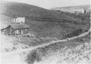
![]() |
| Lexington from an adjacent hill, looking north. Los Gatos Creek runs down the center of the photograph |
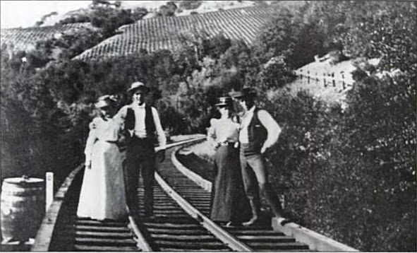
![]() |
| People on a stroll on the tracks to Alma, near Lexington. |
![]() |
| A Southern Pacific train driving by Lexington, 1909. |
But after only a short period of time, Lexington began to decline, due largely to lumbering operations being moved up Los Gatos Creek past Alma. Most of the virgin redwood forests around the area were decimated and never returned. The first sign of decay was the removal of the post office from Lexington to Alma in 1873. Five years later, South Pacific Coast Railroad basically ended Lexington's existence by bypassing the town completely, choosing Alma instead as its hub. Stagecoaches, too, began rerouting to Alma, ending all tourist and commuting traffic to the town. Los Gatos began developing as the economic hub of the area, while Alma became the tourism and logging center.
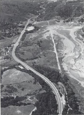
![]() |
Lexington Reservoir drained in 1991, showing the
path of the Glenwood Highway. Lexington was near
the center-right of this photograph. |
Lexington continued to exist, albeit at a reduced capacity, until the reservoir inundated the town in 1952. The town was made briefly infamous when Lloyd Majors, Joseph Jewell, and John Showers brutally murdered Archibald McIntyre in the town in 1884. But what really is surprising is that the town suddenly appeared on Southern Pacific Railroad timetables beginning in the 1910s. Under the new name
Lyndon, named after the old general store owner, the flag-stop developed from a simple platform built beside the tracks. The platform continued to be used until the line closed in 1940, though its last mention on a timetable seemed to be in 1937.
Only around 100 people lived in Lexington and Alma combined in 1952 when the dam was erected. All of them were relocated, though one protested until the end. The reservoir took on the name of the town as a constant reminder of the early settlement that once struggled in the valley. Sadly, today only rubble foundations and a single bridge built in the 1920s survive, visible when the reservoir is drained for maintenance or during droughts.
Citations:- Richard A. Beal, Highway 17: The Road to Santa Cruz (Pacific Group, 1991).
- Peggy Conaway, Images of America: Los Gatos (Arcadia Publishing, 2004).
- Mildred Brooke Hoover & Douglas E. Kyle, Historic Spots in California (Sanford UP, 2002).